Showing posts with label national trust. Show all posts

Monday, 11 November 2024

Osterley parkrun

Osterley is a district of Isleworth, a suburban town within the London Borough of Hounslow, West London. The borough has a population of 290,000 people with Isleworth being home to 25,000, while 13,000 people reside within Osterley itself. Its name is made up of the Old English words 'Eowestre' which means 'sheep barn' or 'sheep fold', and 'Leah' identifying a woodland clearing or meadow. The first mention of the area's name appears to date back to the reign of Edward I when then land was owned by John de Orsterlee. It may also have been the site of a Norman fort or watch tower which would have been used to protect the transportation of provisions between London and Windsor.


The Manor of Osterley, as it was known, passed between a number of different hands until in 1562 it came into the possession of Sir Thomas Gresham. It was Sir Thomas who enclosed 600 acres of land and, by 1577, also had the existing farmhouse replaced with a manor house. It was quite a grand place by this time and its grounds contained woodland, ponds, a number of mills and a heronry. Such was its grandeur that Queen Elizabeth was a guest on two occasions in 1578. Another significant point in the manor's history was in 1713 when it became the property of Sir Francis Child, Lord Mayor of London, politician and the founder of Child & Co, the UK's oldest bank (also the third oldest bank in the world).

It was one of Sir Francis' descendants, also called Francis Child, who inherited the estate and between 1760 and 1778 commissioned architect Robert Adam to transform it into the striking neoclassical grand mansion that still stands as the centrepiece of the estate. Such is its grandeur, it has been described as being the 'palace of palaces'. In 1804 the estate came into the possession of the 5th Earl of Jersey, who had married into the Child family, and it remained with them until the 1940's when it was gifted to the nation by the 9th Earl of Jersey. Following many years of being leased from the Ministry of Works, the National Trust took full ownership in 1991 and it remains one of their properties to this day.


Osterley Park, the grounds in which the mansion sits, is one capital's largest open spaces and one of the last complete country estates in London. It encompasses 500 acres in total, which includes a working farm. In the 1960's the M4 motorway was constructed through the estate, splitting it in two. The northern section is largely farmland while the southern side contains the 356 acres which are managed by the National Trust and are open to the public. This part contains the mansion, a Tudor stable block, formal gardens, a walled garden, garden house, new and ancient woodland, two lakes and acres of ancient parkland. The parkland itself has gone through multiple changes over the years including some time when it was a deer park.

I first visited the estate on 31 August 2013 to take part in the inaugural event of the venue's free, weekly, timed 5k event called Osterley parkrun. The event is open to all abilities including people who wish to walk the course. It is a well-established community event which offers plenty of opportunities to become involved, including as a volunteer. Upon entering the grounds from Jersey Road there is an 850-metre-long walk to the parkrun meeting point which is located right in front of the stunning red-bricked mansion. There are on-site toilets and these are located about 100 metres to the north of the mansion, adjacent to the stable block.


When I visited in 2013 I cycled to the venue and used the cycle racks next to the stable block, I can confirm that as of November 2024 the racks are still located in the same spot and can accommodate approximately 15 bicycles. However most cyclists seem to use the fence that surrounds the front lawn of the house. When I revisited in 2024 I used the car to make the journey and parked in the onsite parking facilities. The estate has two car parking areas which are both accessed via the park's main entrance on Jersey Road. The National Trust Osterley Park and House website advises that there is a fee to park onsite, however this does not apply to those taking part in the parkrun as a special arrangement is in place that exempts attendees from the charge. The general expectation is that parkrunners will vacate by 11am. Anyone wishing to stay longer may be required to pay the parking fee.

The park is easily reached via public transport. The closest station is Osterley tube station which is served by London Underground services on the Heathrow branch of the Piccadilly Line. This gives quick and easy access from both the centre of London and from Heathrow airport. The onward journey on foot to the parkrun meeting point is 1 mile (1.6km). Isleworth is the closest mainline railway station, but is further away from the park. The onward journey from here is 1.6 miles (2.4km). Isleworth station is served by South Western Railway services running between London Waterloo and Weybridge, in Surrey. There are also bus services that stop close-by, the closest being the H28. However the H91 stop is also near-by, next to Osterley tube station.


The parkrun takes place over a two-lap clockwise course around the northeast corner of the National Trust managed grounds. The course is essentially pancake flat making it a pretty fast course for anyone looking to set a good time. Underfoot, the surfaces are all hard standing featuring a mixture of tarmac and gravelly surfaces. I imagine most people would be fine in road shoes at most times of the year. In addition to that there is a very short section on grass which leads into the finish funnel at the very end. It is suitable for participants pushing buggies and for those using wheelchairs.

Dogs are welcome but please take note of the venue's Visiting Osterley Park with your dog webpage which outlines specific areas where dogs are allowed off their leads. This area is shown on the venue's official map.

The first timers' briefing and the main briefing both take place in front of the mansion. The first timers' briefing at about 8.50am and the full one once the participants are lined up at the start. The participants are then sent off for their weekly 5 kilometre jaunt around the grounds.


From the start, the course essentially heads to the north where it passes the Stables Cafe and the toilets before bearing to the left when the path splits. After a short avenue of trees the path takes on the feel of a country lane which is bordered by fairly thick bushes. This dead-straight path heads all the way to the park's boundary with the M4 motorway where there is a marshal who directs the participants to their right and onto Osterley Lane, which runs alongside the M4. This is once again a dead-straight path but slightly wider and separated from the busy motorway by a thin band of trees.

The constant hum of passing vehicles is impossible to ignore, but that aside the path is pleasant enough. I'd note the surface underfoot is a little knobbly in this section, which I'm sure buggy pushers and wheelchair users will notice a little more than those purely on foot. Up to this point the course is fairly enclosed with no views of the surrounding grounds of the estate.


Once the course reaches its northern tip Osterley Lane bears around to the right and starts to head away from the M4. At this point the view to the right begins to open up with a fantastic view across Middle Lake towards the mansion. A marshalled point further along the path marks the point where the course leaves the lane.

Now heading back towards the central part of the estate the route looks directly towards the flight path of planes on their final approach into Heathrow Airport, and considering their frequency it is almost certain that you'll see a few passing over. Overall the course features lots of long, straight paths, but this changes in the final section of the lap. Firstly the route passes through a very small patch of woodland where the path twists and meanders its way through before exiting and passing the car park areas.


Then it follows the path that curves around the northern tip of Garden Lake - if you are going for a time there is the temptation to follow the racing line next to the water's edge, which is fine but there is no barrier or grass between the path and the water, so be careful. You may also have to keep an eye out for the ducks.

Upon reaching the mansion, the lap is complete and lap two is identical to the first. At the end of lap two the course peels off to the right onto the grass where it almost immediately enters the finish funnel and finish tokens are handed out. If you happen to be further back in the field and are being lapped, it is best to keep to the left on the approach to the house at the end of the first lap to allow those finishing access to the finish. Barcode scanning takes place over at the mansion's steps and the post-event refreshment venue is the Stables Cafe which is just a few metres away. It has both indoor and outdoor seating, and serves all the usual offerings that you'd expect from a National Trust cafe.


The results were published later that day and there were 496 finishers on 9 November 2024. This was a bit higher than the average as we had visited to join in the celebrations at the parkrun's 500th event. The usual expected number of attendees tends to sit somewhere in the mid-300's. At time of writing, the all-time attendance record stands at 744 and was set on 1 January 2020 where Osterley had a 10.30am start as part of that year's New Years Day double. The rest of the top five highest attended events are made up of event 300, 2019's New Years Day event, and then two from 2024, including at fifth place, event 500!

In terms of the course, the current two lap course, which has been in operation for most of the event's life, is different to the one used when I was last here at event 1. That original course was three laps and multi terrain. I have the GPS data for both courses, so pop over to Strava to see the data from the original course or the current course. The GPS data from my 2024 visit has been converted into a short fly-by video using the Relive app, it can be viewed on YouTube.


The parkrun itself doesn't suffer from too many planned cancellations, but they can occur when another event is using the park or if a film crew is on-site (it is a popular filming location, see below). Other cancellations are mostly weather-related at short notice, and as the event is held on private property, sometimes the decision to close the grounds is made by the National Trust, leaving the parkrun's core team with no choice. As always information can be found via the event's news page, social media pages or via the official parkrun UK cancellations page.

Post-parkrun you can of course stay on-site and explore some more. If you would like full access to the gardens and the mansion you'll need to pay the entry fee. Of course National Trust members can do all of that for no extra on-the-day charge. Another fact about the house is that it has featured as a backdrop in quite a number of films and TV shows, mostly, but not exclusively, period dramas. Some notable ones are The Crown, Miss Potter, Mansfield Park, Holmes & Watson, Cranford, The Duchess, The Persuaders, Top Secret, and The Dark Knight Rises (Batman). On this occasion we wound up our visit and left the car park at about 10.30am as we had other plans elsewhere in London.


The visit to Osterley House and Park had been very pleasant and we were very well looked after by the volunteer team and other locals. A huge thank you goes to everyone involved.


Related Links:


Tuesday, 22 August 2023

Lyme Park parkrun

The Unitary Authority of Cheshire East has a population of around 400,000 people and sits within the ceremonial county of Cheshire, in the North West Region of England. Historically the area has strong links with the textile industry, with notable towns being Wilmslow, well known for cotton, and Macclesfield which was once the world's biggest producer of finished silk. The far north-east of the area is home to the village of Disley, which sits just a stone's throw away from the large, historic country estate of Lyme Park.


Lyme Park covers an area of around 1,400 acres and sits in the parish of Lyme Handley within the Peak District National Park. The majority of the grounds are made up of a vast deer park which is home to a herd of Red Deer. These are thought to be direct descendants of the original deer that were present when the park was first enclosed in the 14th century. The land was granted to Margaret Legh, daughter of Sir Thomas Danyers, by King Richard II in 1398. The estate also features 15 acres of formal gardens.

The central feature of Lyme is its glorious mansion; construction of this house began in the 16th century, and further alterations were made in the 17th and 18th centuries. It is noted to have Elizabethan, Palladian and Baroque features. The estate was home to the Legh family for almost 550 years (although an engraved stone on the house says 600 years), when in 1946 it was given to the National Trust. In 1983 it was designated Grade I Listed status. It was managed by the Stockport Corporation / Stockport Metropolitan Borough Council until the National Trust took over completely in 1994. 


We visited the estate on 19 August 2023 to take part in its free, weekly, timed 5 kilometre event called Lyme Park parkrun. The parkrun event has been in place since 22 February 2014 and is open to all abilities including those who wish to walk. We travelled by car, but as we live in Kent, we stayed overnight in a Premier Inn before making the short journey by road on the morning of the event. For the record the closest Premier Inn is Stockport South (6.5 miles), however we had chosen to stay in the Macclesfield North Premier Inn (12 miles away). There are also some independent hotels in Disley.

Arrival by vehicle is simple enough, but please note the official opening time for the car park is 8.30am, so there's no point in arriving any earlier than this. In fact arriving early can cause a blockage on the A6 just outside the main gate. There is a large on-site car park which is free-of-charge, and parkrunners also get to bypass the usual entry fee for the grounds. If travelling by public transport, Disley Station is the one to head for (approx 30 minute journey time from Manchester). Google maps reports the walk to the centre of the park as being around 2.5 miles, so make sure you leave enough time to cover the distance. For those using bus services, the 199 Skyline and the 360 both seem to stop outside the main vehicle entrance. If you travel by bicycle you can secure it at the bicycle rack in the car park.


Once on-site the toilets are noted as being open from 8.30am, so that ties in nicely with the gate opening time. They are located at the Timber Yard Cafe building, but please note that this is in the opposite direction to the parkrun meeting point, so don't arrive too late if you think you'll need to use the facilities pre-parkrun. The meeting point is on the open grass area to the south of the car park, and this is where the main briefing was held. The event also starts around this point, but the finish is in a different location.

Lyme Park parkrun uses a point-to-point route, but is probably mostly referred to as a 1 lap course. Underfoot is a mixture of surfaces, including loose stones, rocks, woodland paths, tarmac and grass. The official course page describes it as 'Breathtaking. Literally!'. The first word of the quote is a double entendre, with the main gist of this being that it is hilly. In fact, it is in the top ten of the hilliest UK parkruns. The second meaning will become apparent later on.


As for footwear, it is an off-road type of course, so in the winter trail shoes are a must. My personal preference would be to use trail shoes all year round. Buggy runners are welcome at Lyme Park parkrun, all I'd say is note the above and be prepared for a tough course with very uneven surfaces at times. If you were to look it up on the 5k app, it is noted as not being suitable for buggies.

Dogs are also welcome here, but do bear in mind that it is a deer park so it is worth checking the 'Visiting Lyme with your dog' page beforehand. I would say that this course is not suitable for wheelchair users. Please also note that there are electric fences in certain points around the course.


On the day we visited, the parkrunners and volunteers congregated at the refreshments hut in the car park. The first-timers briefing was held here before moving across to the south side of the car park. The parkrun starts at the gate and first makes its way along the Gritstone Path heading to the south. The path is part of a much longer, 56 kilometre walking route, called the Gritstone Trail, which runs from Disley to Kidsgrove. The initial stretch of the course is initially quite narrow, underfoot is very stony, and the first 500 metres are a pure relentless climb averaging between 10% and 13% incline. The first 400 metres have a lightly wooded area to the left, which many participants chose to run or walk through rather than sticking to the rocky path. To the right is open grassland with a view across Drinkwater Meadow and beyond.

Upon reaching the 400 metre point, there is a second gate and this takes the parkrunners into Knightslow Wood. At first the incline maintains the same trajectory, but it does ease off and become relatively flat for a bit, before climbing again, but at a less severe 5%. Underfoot is a forest trail path. The 800 metre point, which is also the southernmost point of the course, is the location of another gate. This point features a 90 degree left hand turn and after a little bit more gentle climbing the highest point of the course is reached. 


The woods and the park's boundary wall are on the left and on the right hand side is open land, where you may spot some cows grazing on the other side of the electric fence. This path is sometimes referred to as The Rollercoaster, as it flows up and down. One of the short downhills is particularly steep. From this section onwards I seemed to become the focus of interest for a swarm of flies and they would not leave me alone for the rest of the parkrun. I was aware that some other parkrunners were having similar struggles, but there were other people who were not affected at all.

Another left hand turn and another gate marks the point where the parkrun is closest to one of the park's interesting features, an octagonal tower called The Lantern. You can't see it from the course because it sits within Lantern Wood. There are many theories to its origin and purpose, but the most-common suggestion is that it is a folly, constructed to be viewed from the dining room in the mansion. It is Grade II Listed. The course at this point continues the downhill theme as it follows the path to the east of the main house, which despite its size, is not visible from the parkrun course. 


Leaving this area, the course again starts to climb. First on a tarmac path, but shortly after onto grass where the terrain becomes more rugged and open. In the distance is another of the park's iconic features, the large, square sandstone building called The Cage. A structure called The Cage has been in existence since around 1580, however the original building was taken down and rebuilt between 1734 and 1737. Its exact purpose is not known, but it is most likely to have been a hunting lodge. The hunters would have used the building to spot the deer, before heading out on their hunt. The ladies would remain in the building to watch the hunt from the building's elevated vantage point. Afterwards they would have dined on the first floor.

The parkrun route heads straight towards The Cage, the path climbing gently until reaching the base of the three-story building. The view from this elevated position reveals the second meaning of the course page's description, breathtaking! On a clear day you can see into Greater Manchester and also across towards Kinder Scout, in Derbyshire, which is the highest point in the Peak District. During parkrun there's not really time to take it all in, so it is worth making a note to walk back over afterwards. The course then continues straight past The Cage and starts to head down the hill.


The downhill section here is fairly steep and continues for exactly 1 kilometre all the way to the northernmost point of the course. Underfoot is mostly a rocky path which is quite treacherous. At the very end of the downhill section, at 3.7 kilometres into the event, there is a sharp left hand turn. This is the lowest point of the entire course, and you know what that means, don't you? The final 1.3 kilometres is all uphill. On paper the first part is the hardest as it registers around a 10% incline for a few hundred metres. The incline does ease off a little after that, but at this stage in the parkrun any uphill is going to feel tough.

The final stretch of path heads just to the west of The Cage and leads towards the finish line, which as noted above is in a different location to the start. Barcode scanning takes place straight after the finish funnel. From here it is a short walk back to the car park, or to the parkrun's official post-event refreshments venue, the Timber Yard Cafe. They had the usual selection of drinks and cakes, but the choices for food were quite limited - even more so when it comes to vegetarian or vegan options. However, the staff were nice enough to prepare a not-on-the-menu food item for my daughter. Other refreshments options are the hut in the car park, or there's another cafe in the mansion itself.


The parkrun results for event number 414 were published later that morning and 168 people had taken part. This figure was at the higher end of the normal attendance figure. A normal week tends to be in the 100-150 range, but this can dip under 100 when the weather conditions are not favourable. I did of course record the course with my Garmin, and the course data can be viewed on Strava. The total elevation was 127m according to my readings. That GPS data was also used to create a Relive course fly-by video which can be viewed on YouTube.

If visiting this venue, it would be wrong to leave without taking a proper look at the mansion. So after our refreshments that's what we did. As we were already in the grounds we could freely explore them without a charge; this includes the deer park and the formal gardens, but not the interior of the house itself - for that you would need to pay an additional fee. The formal gardens are very nice indeed, but there was one spot I wanted to go to, and that is on the south side of the lake. This is where the classic viewpoint of the house can be found, and it is fantastic. Fans of TV or films may recognise the house from the BBC's version of Pride and Prejudice (1995), but it was also used in The Village (2013-14 TV series) and in The Awakening (2011), and many others.


Once we had finished exploring the formal gardens, we headed back up towards The Cage. Quite unexpectedly we found that it was open to visitors between 12 and 3pm, so we also had the opportunity to go inside The Cage, but only the ground and first floors because apparently the upper floor was in bad condition and not suitable for visitors. Sadly we ran out of time and didn't get to see The Lantern. Another spot that we didn't quite manage to get to was the Bowstones, which are a bit further along the Gritstone Trail - you can apparently see into seven different counties from here.

Our extended post-parkrun walk had clocked up at a further 8 kilometres, so a 13 kilometre stint of combined running and walking was about enough for us by this point in the day. It was still only about 2.30pm, but it was now time to leave Lyme and continue our adventures elsewhere.


This event had been in my calendar for at least 18 months prior to our visit, so it was brilliant to finally have the opportunity to take part in a parkrun in this very special place. Everything had been amazing (we'd also had a little family event to celebrate, which tied in with being at Lyme on this particular date). A huge thank you goes to all of the volunteers, especially to the day's Run Director who was kind enough to make a special announcement to the crowd during the main briefing. We were made to feel very welcome and this is definitely a very memorable and special place to visit.


Related Links:

My GPS data of the course (19 August 2023)


Monday, 20 June 2022

Fountains Abbey parkrun

In the year 1132 a group of 13 monks were unsatisfied with the indulgent lifestyles lead at Benedictine house of St Mary's Abbey in York. They craved a simpler, more humble, life, and were eventually expelled following a dispute and riot. These monks were subsequently taken under the protection of the Archbishop of York who provided them with some land in a valley where they could create a monastery. Along this valley flowed the River Skell. The site contained six springs and this inspired the Monks to call the area 'Fountains'.

In 1135 Fountains Abbey joined the Cistercian order, which called for a life of self-imposed hardship, and became the second Cistercian house in northern England (the first was the nearby Rievaulx Abbey). In the very early days the abbey would have been a simple wooden building, but construction of the stone buildings began and the main section of church completed around 1160. At this time it is estimated that around 60 monks and 200 lay brothers would have resided here. The monks' main focus was reading and prayer, and the lay brothers took care of everything else with many of these being skilled craftsmen.


The monastery by this time had acquired significant areas of land, much of which was used for farming and this, of course, contributed towards the growing wealth of the monastery. It is reported that the fleeces from their sheep were exported all the way to Italy. It had also become pretty much self-sufficient. In addition to the main church were the monks' and lay brothers' living quarters, kitchens, infirmary, guest houses, tannery and a mill. A 300ft long Cellarium was constructed (possibly not all at once), this section of the building would have been called the Great Cloister. The final significant element of the church to be constructed was the 160ft tall bell tower named ' Huby's Tower' after the Abbot Marmaduke Huby, the 37th Abbot of Fountains.

The monastery was the wealthiest Cistercian monastery in England when King Henry VIII's 'The Suppression of Religious Houses Act 1539' came into law. This triggered the process known as The Dissolution of The Monasteries. The buildings and over 500 acres of land were seized by the Crown and the following year were sold and gradually stripped of valuable materials such as lead, timber and stone (a condition of sale was that the buildings must be made unfit for worship). In the early 17th century further materials were removed and used in the construction of a country house named Fountains Hall.


The estate of Fountains Hall (including the remains of the Abbey) was purchased in 1742 by William Aislabie, who owned the adjacent Studley Royal Estate and the two were merged. The Aislabie family had created a stunning Georgian water garden which is said to have been England's most important 18th century water garden. In 1966 the estate was bought by West Riding County Council and in 1983 was acquired by the National Trust, who run the site to this day. Fountains Abbey itself is maintained by English Heritage. In 1986 'Studley Royal Park including the ruins of Fountains Abbey' became a UNESCO World Heritage Site.

The modern day estate is now over 800 acres in size and can be visited all year round. Along with the abbey and the water garden, the estate is also home to the Church of St Mary and Studley Royal Deer Park which is home to 350 Fallow, Red and Sika deer. Being a National Trust property there is an entry fee of £17 for adults and £8.50 for a child (prices correct as of 2022). There are of course family tickets and various other discounts available. Naturally if you are a National Trust or English Heritage member you can enter for free. It's worth noting that the church and the deer park are outside of chargeable area so can be visited without paying the entry fee.


In March 2014 the estate became home to Fountains Abbey parkrun and after years of it being number 1 on my must-visit parkrun list, I finally made the decision to book a hotel and make it happen. With North Yorkshire being a popular tourist destination, there were many accommodation options ranging from hostels, B&Bs, hotels and even options for yurts and glamping. For those looking for something extra special, I hear that you can even stay within the grounds of Fountains Abbey and Studley Royal. We chose to stay in a Premier Inn, which worked well for us as a family. There were options in Harrogate, but we stayed at their Thirsk hotel which is just under 30 minutes drive away from Fountains. This made for a simple journey on the Saturday morning via Ripon where the route was clearly marked with the brown tourist information road signs.

Upon arrival at Fountains Abbey we parked for free in the main visitor centre car park which is just off Abbey Road (technically there are three car parks here; A, B and overflow. We parked in A). However, since we visited, the parking arrangement has been changed and all vehicles arriving for parkrun must be parked in the overflow car park. There are other car parks dotted around the estate, but access to the site for the parkrun is only possible via the visitor centre so make sure you go to this one. Travelling by vehicle is really the only way to arrive at Fountains Abbey as there are no bus services until later on in the morning. From what I can see the closest railway station seems to be in Harrogate which is about 10 miles away. If you happen to be cycling, the Way of the Roses cycle route passes the venue. Cycle racks can be found right outside the visitor centre.


The grounds officially open at 10am, however on Saturday mornings parkrunners can enter for free for the duration of the parkrun event. It is very important that if attending the parkrun you have parked and got yourself through the gates and down to the meeting area well in advance of 9am as the staff close and lock the gate to prepare for the day's paying visitors. The walk from the entrance drops you down into the Skell Valley to the parkrun meeting point. It can take around 10 minutes to walk down. However, if you have kids with you they'll probably be distracted by the brilliant playground so it's worth planning extra time for that.

The main toilet facilities are located in the visitor centre at the main entrance, however if you make it all the way one down to the meeting point before feeling the call of nature, there is a second toilet block just next to the Grade I Listed Fountains Hall, which is just to the west of the ruins of the abbey (follow the path to the right as you descend) - don't forget to check out Fountains Hall if you visit these toilets. Anyway, it will be very obvious where the parkrun meeting point is from here as you'll see the usual parkrun paraphernalia and hi-vis vests of the day's volunteers dotted around on and beside the west lawn.


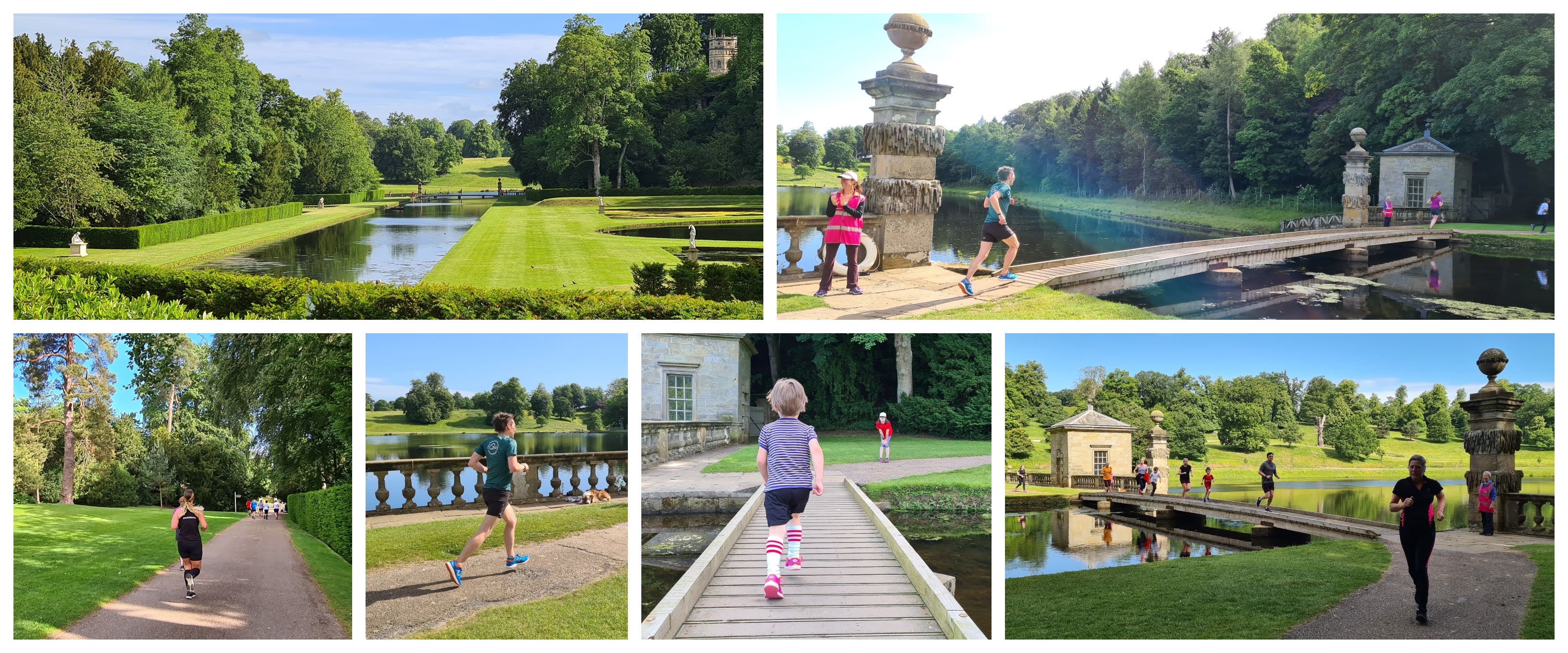
The main thing you'll do at this point is gaze upon the remarkable ruins of Fountains Abbey. From this viewpoint you'll be able to see the western end of the Nave and the remains of the Great Cloister (which contains the Cellarium) stretching out alongside it. It's worth popping inside as you'll see the incredible vaulted ceiling and rows of gothic pillars. Just to the right you'll see the remains of what was the Hospitium - a lodging house for guests. The abbey and extended buildings are home to eight species of bat. As it nears 9am you'll have to divert your attention away from the abbey to listen to the briefings.

The parkrun takes place on hard paths with absolutely no grass or mud sections to negotiate, so road shoes should be sufficient all year round. The course is run in a clockwise direction and is made up of a short lap followed by a longer one which is actually not quite a full lap (you can see what I mean by checking my GPS data or Relive Fly-by video). This course configuration has been especially designed to try to ensure that no participants are lapped - my wife went around with our 4 year old in 55 minutes and was only lapped by the first few very speedy finishers. The profile is largely flat, but contains a few ups and downs at various points. Buggy runners are of course welcome here and all the usual considerations apply.


From the start the participants head in an easterly direction towards the abbey and along its northern side, passing directly in front of Huby's Tower on the way. The path is only regular width so you may find a bit of congestion at this stage of the event. Once past the church the East Lawn comes into view. It had been known for many years that this area had been used as a cemetery for the Monks and lay brothers, however the true scale of it was not known until the area was surveyed with radar technology. The results showed that there are 500 graves present under the lawn using a bunk bed system of burial. Each of the graves could contain four bodies meaning there could be up to 2,000 buried here.

Continuing along the path which follows the inner curve of the valley, it's not long before the course makes its first crossing of the River Skell. From here the course heads around the outer curve of Half Moon Reservoir to start heading back westwards. Here you get to take in one of the classic views of Fountains Abbey - The gently meandering river and the lawn in the foreground, flanked by trees on either side and the striking eastern face of the abbey in the distance. If the conditions are right, the reflection of the abbey will be seen in the reservoir. This end of the church contained the Chapel of 9 Altars.


A loop of the abbey follows, which includes a second crossing of the river, this time via Mill Bridge, which as you may expect is located near the mill. The mill is the oldest building on the estate and continued to be used to grind grain right through until 1927. There is also a bell on the side of the building which visitors are free to ring, should they wish. You can't see the mill from the parkrun course, but it's easy to take a peak before leaving.

Once over the bridge the course passes the original meeting point and start area where the second, longer, lap starts by following the same path eastwards past the abbey. Once around the inner curve for a second time, the course continues onwards and into the main section of Studley Royal Water Gardens. In this area you will notice that the River Skell has been painstakingly engineered into a perfectly straight ornamental feature where it has been given the name of 'Upper Canal'. A bit further along it features a perfect 45 degree angle turn (I checked by using a protractor against the online map). You may need to pop your head through the gaps in the hedges to get a proper look at the water.


On this side of the river you may spot the Banqueting House which is the first of the many follies within the water gardens. The water remains out of view at this stage of the event as the paths pass through a slightly wooded section before entering back into an area of beautifully manicured grass, shrubs and trees. There is even a solitary white bench. Next up comes the final crossing of the river and is achieved via a pretty special feature. It's a narrow, wooden bridge with no sides which must be negotiated in single file. The river flows underneath and then heads down a small water cascade into the ornamental Studley Lake which has a decorative stone balustrade along the edge. It is marshalled by two volunteers who have a lifebouy to hand just in case somebody takes an unintended dip into the Skell.

Upon reaching the opposite bank the surface underfoot changes from smoother tarmac into a stony path for a short stretch. This leads through another shadier section where just out of sight through the overhanging trees is another folly, this one is called the Octagon Tower. As things open up the Moon Ponds come into view. This part of the garden has a Roman theme and sitting perfectly placed opposite the circular pond is the Temple of Piety, yet another of Studley's follies. If you look closely you may see three statues. These are the Roman gods Neptune and Bacchus, and Galen (renowned physician and philosopher). A fourth statue, The Wrestler (copy of a famous Roman statue) can be seen on the opposite bank in front of the half-moon pond. These may look like stone, but they are in fact made from lead and painted to mimic a marble finish - this was common during the 18th century.


The course continues to meander along the perfectly formed path until it re-joins the section that was covered earlier as it makes its way back around the outer curve of Half Moon Reservoir. This time around the finish line is not far away. The finish line itself stretches across the entire path, so once you've crossed you can't really go back (say, to take photos or something) without potentially causing issues with the finish line team. You may spot what is known as Robin Hood's Well right next to the finish - the small stone construction is thought to have been made in the 1800's from stone reclaimed from the abbey. But where did its name come from? Well, it is said that Friar Tuck, one of Robin Hood's merry men was once a monk at Fountains Abbey.

Once in possession of a finishing token, the participant's need to continue along the footpath for another 300 metres or so where a line of smiling volunteers will be on the grass waiting to take care of scanning. Before reaching them there is a very special viewpoint overlooking the abbey so it's worth taking some photos before moving on. With that done, depending on the time, you'll need to generally start to make your way back towards the visitor centre where you can have some refreshments if you wish. Of course if you feel as if you need more time to explore the grounds, you can of course re-enter the estate via the general admission system.


I had spent the event running with Nicola Forwood, one of the presenters of the With Me Now podcast (and before that, The parkrun Show), so that was an unexpected, but very nice way to spend the 33-and-a-bit minutes it took to get around. It definitely made the event extra memorable. The results were processed and published a short while after and 326 people took part in event number 348. At time of writing (June 2022), this is slightly higher than the official average, but comfortably within the expected number which tends to be in the 300-400 range.

During my post-parkrun exploring (to take extra photos) I bumped into one of the marshals who told me that the original proposal for the parkrun route was for it to be located within the deer park, meaning the abbey and the water gardens would not have been seen during the event. Thankfully a member of staff at the abbey suggested an alternative route and the rest is history. Fountains Abbey parkrun also has its own 'portmanteau word' so it is usual to find Fountains Abbey described as Fabbey or Fabbey parkrun, in fact the parkrun event's Twitter handle is @fabbeyparkrun. It's also worth noting that the mobile phone signal is almost non-existent, especially down in the valley itself.


The abbey has been used as a backdrop in films and TV shows. The most notable for me was The Witcher, season 2 episode 3 where Yennifer saves Cahir, which I had watched just a few weeks before visiting (watch this and this). It was also the filming location for the Orchestral Manoeuvres in the Dark - Maid of Orleans music video. Other films include The Omen 3, where the final scenes take place here, and also The Secret Garden (possibly scenes inside Fountains Hall) and a few others. There have been multiple historic TV documentaries filmed here, plus The Antiques Roadshow of which the full 44 minutes episode is also on YouTube.

And with that our morning at Fountains Abbey drew to a close. It certainly lived up to expectations of being one of the finest parkruns out there. It got me thinking that if this parkrun featured just the abbey or just the water gardens, it would still be a stunning venue, but to have both elements in a single event really makes this one of parkrun's truly iconic venues. If you have even the slightest hint of an opportunity to visit, it is definitely worth doing so.

Many thanks to all of the volunteers that put the event on and made us feel so welcome during our visit.

Related links:

Fountains Abbey parkrun (my GPS data from 18 June 2022)


My pre parkrun exploring GPS data (starts from the car park and finishes at the start)
My post-parkrun exploring GPS data (starts from the finish line and finishes back at the car park)


Wednesday, 27 January 2016

National Trust parkrun venues

The National Trust are great supporters of parkrun and kindly allow many of their venues to be used for parkruns. They are generally off-road courses and beautiful places to run. If you were making a 'must-do' list, then these venues would be a good place to start. The National Trust have their own webpage showing which venues are home to parkruns, you can find it here - National Trust parkrun Venues (page no longer seems to exist)

For the list below I have ordered the venues by name of the parkrun rather than name of NT venue, which may differ slightly.

As the venues are widely spread across the country, I haven't visited many of them. I'll try to tick off the odd venue every now and then, but almost all of them require a long drive and probably an overnight stay. It will be extremely slow progress.

Map: The green pins show the venues I have officially visited while the red pins are venues that I still need to visit.


Bath Skyline parkrun - Bath Skyline, Bath, Somerset
Course: A small loop followed by a big loop
Underfoot: Gravel, stone, grass
Profile:
Notes: Steps on course - not suitable for buggies
Further Reading: NOT YET VISITED


Belton House parkrun - Belton House, Grantham, Lincolnshire
Course: Two anti-clockwise laps
Underfoot:
Profile:
Notes:
Further Reading: NOT YET VISITED


Blickling parkrun - Blickling Estate, Aylsham, Norfolk
Course: Almost two laps
Underfoot:
Profile:
Notes:
Further Reading: NOT YET VISITED


Bolberry Down parkrun - Malborough, nr Salcombe, Devon
Course: Three laps
Underfoot: Grass, gravel, tarmac
Profile: Flat
Notes:
Further reading: not visited


Clumber Park parkrun - Clumber Park, Worksop, Nottinghamshire
Course: Two laps
Underfoot:
Profile:
Notes:
Further Reading: NOT YET VISITED


Colby parkrun - Colby Woodland Garden, Ambroth, Pembrokeshire
Course: Three laps
Underfoot: Trail paths / grass
Profile: Undulating
Notes: Set in a tranquil secret valley
Further Reading: NOT YET VISITED


Cotsford Fields parkrun - Cotsford Fields, Cotsford Lane, Horden, County Durham
Course: Two laps
Underfoot: Multi terrain
Profile:
Notes:
Further reading: not visited


Dunstable Downs parkrun - Dunstable Downs, Whipsnade, Dunstable, Bedfordshire
Course: One lap
Underfoot: Grass and trails
Profile: Undulating
Notes: No dogs permitted / May be difficult for buggy runners (check with team before visiting)
Further reading: My Dunstable Downs parkrun write-up from 2022


Erdigg parkrun - Erdigg Hall, Wrexham, Clwyd
Course: A single loop
Underfoot: Trail and gravel paths
Profile:
Notes:
Further reading: Not visited


Fell Foot parkrun - Fell Foot, Cumbria
Course: Figure of eight with top loop run twice
Underfoot:
Profile:
Notes: It's run next to lake Windermere. Need I say more?
Further Reading: NOT YET VISITED


Fountains Abbey parkrun - Fountains Abbey, nr. Ripon, North Yorkshire
Course: A short lap followed by a longer lap
Underfoot: Firm footpaths
Profile: Gently undulating (but mostly flat with some inclines)
Notes: The ruins of the abbey plus the immaculate Studley Royal Water Gardens
Further Reading: My Fountains Abbey blog post


Hatfield Forest parkrun - This venue is no longer active (since 23 September 2017)
Course: One lap (technically point-to-point)
Underfoot: Tarmac, grass, mud, puddles
Profile: Almost completely flat
Notes: Set in a stunning medieval forest
Further Reading: My Hatfield Forest parkrun blog post


Killerton parkrun - Killerton, Devon
Course: One lap
Underfoot: Trails / grass
Profile:
Notes: Scenic
Further Reading: NOT YET VISITED


Lanhydrock parkrun - Lanhydrock, Devon
Course: One lap
Underfoot:
Profile: Undulating / hilly?
Notes:
Further Reading: NOT YET VISITED


Lyme Park parkrun - Lyme Park, Disley, Cheshire
Course: One lap (point-to-point)
Underfoot: Stones, woodland path, grass, tarmac
Profile: Hilly
Notes: The stony surface underfoot can be quite challenging / lovely views
Further Reading: My Lyme Park parkrun write-up (2023)


Newport parkrun - Tredegar House, South Wales
Course: Two laps
Underfoot: Gravel / bark / compact earth / grass
Profile: Flat
Notes:
Further Reading: NOT YET VISITED


Nostell parkrun - Nostell Priory, Yorkshire
Course: Two laps
Underfoot: Tarmac, bark, trail, grass
Profile:
Notes: Barcode in window for free parking
Further Reading: NOT YET VISITED


Osterley - Osterley Park, Isleworth, West London.
Course: Two laps
Underfoot: Tarmac, gravel and a tiny bit of grass at the end
Profile: Flat
Notes: National Trust managed house and grounds
Further reading: My 2024 Osterley parkrun write-up. Also my original 2013 Osterley parkrun blog post


Parke parkrun - Parke, Bovey Tracey, Devon
Course: One lap (?)
Underfoot:
Profile: Hilly / Undulating
Notes:
Further Reading: NOT YET VISITED


Penrhyn parkrun - Penrhyn Castle, Gwynedd
Course: Two big loops and two small loops
Underfoot: Tarmac and gravelly paths
Profile: Undulating
Notes: Beautiful and picturesque
Further Reading: My Penrhyn parkrun blog post


Penrose parkrun - Penrose, Helston, Cornwall
Course: One lap (point-to-point)
Underfoot: Woodland and coastal paths
Profile:
Notes:
Further Reading: NOT YET VISITED


Plym Valley parkrun - Plymbridge Woods, Devon
Course: One lap
Underfoot: Grass / tarmac / woods
Profile: Undulating / hilly
Notes:
Further Reading: NOT YET VISITED


Sheringham parkrun - Sheringham Oark, Norfolk
Course: One lap
Underfoot: Woodland paths (firm but can be muddy)
Profile: Undulating
Notes:
Further Reading: NOT YET VISITED


South Shields parkrun - The Leas, Tyne and Wear
Course: One lap (point-to-point)
Underfoot:
Profile:
Notes: Follows part of the route of the great north run
Further Reading: NOT YET VISITED


Trelissick parkrun - Truro, Cornwall
Course: Lollipop
Underfoot: Off road - woodland paths
Profile:
Notes:
Further reading: Not visited


Wakehurst - Wakehurst, Ardingly, Haywards Heath, West Sussex
Course: Two clockwise laps
Underfoot: Resin and tarmac paths
Profile: Some steepish climbs (tbc)
Notes: No dogs allowed. Owned by NT, but the grounds are managed by Kew Gardens.
Further reading: My Wakehurst parkrun write-up from May 2024


Wimpole Estate parkrun - Wimpole Hall, Cambridgeshire
Course: Out-and-back
Underfoot: tarmac / grass
Profile: Undulating
Notes: Has cows and sheep on the course.
Further Reading: My Wimpole Estate parkrun blog post (old course) (re-write required)


Woolacombe Dunes parkrun - Woolacombe, North Devon
Course: 1 lap
Underfoot: Stone, sand dunes and beach
Profile:
Notes:
Further reading: not visited


Please note: Information contained within the blog posts, such as the course configuration, parking arrangements, availability of toilets etc, may change. Please always check with the relevant events' web page and social media channels for the latest and most accurate information.


If you find the write-ups useful and wish to support the blog, please consider doing so via the button below. Thank you.


Saturday, 31 August 2013

Osterley parkrun

Please note: This is an old post and some details have changed including the course. I revisited in November 2024 so please refer to that post for a more up-to-date write-up:


- - -

Upon arrival at the grounds of Osterley Park and House you know you have just entered somewhere special. This is one of the last surviving country estates in London and is managed by the National Trust. The centre-piece of the estate is the Georgian House and is surrounded by gardens, park and farmland.


On 31 August 2013, the estate became home to Osterley parkrun and I was there for the inaugural running of the event. I travelled by bicycle and used one of the bespoke National Trust bicycle racks to secure my bike. If this happened to be full, there is a fence right the way along the path around the finish area that you could use as an alternative.


For those who prefer to drive, there is a car park. The arrangement is that if you show your parkrun barcode to the car park attendant you will be allowed to park free of charge for the duration of the event - if you don't have it you'll have to cough up £3.50 to cover the car parking fee.


Public transport links are good - Osterley tube station is less than a mile away so it doesn't take long to walk or jog to the venue. Isleworth train station is a little further away at 1.5 miles but should still be a viable option for most.


You'll be pleased to hear that there are toilets and they are located right next to the finishing line - on the day I went to the venue they were opened at about 8.20am, that should be early enough for even the keenest parkrunner.


The course is flat, is run over three-and-a-bit laps and starts right next to 'Garden Lake', which is adjacent to the house. The first 150 metres covers the 'and-a-bit' section. You are then required to run three clockwise laps of the course.


The first part of the lap is on a loose gravel surface and continues for about 500 metres before you turn right at the far end of the park and run about 300 metres along a compacted dirt path - this path is definitely not even and contains many large holes which were still full of water even though the last rainfall was almost a week earlier. In the wetter months this is going to be quite a difficult section to run as runners may not be able to judge how deep each hole is.


At the end of this path there is a hard right turn through a narrow gate - this point of the course had a marshal and hopefully always will because it is so easy to run straight past it - I did just that during my recce lap and bumped into a fisherman and a few dog walkers before realising my error.


The next section is a forest trail which takes you along the edge of 'Middle Lake' where you must be extremely careful of the protruding tree roots - I heard of a number of runners tripping as they ran through this section. The first lap is where risk of tripping is at its highest as this is when runners are bunched up and not so able to see the ground clearly.


As you emerge from the foresty bit, the terrain changes to grass for about 600 metres or so (watch out for the odd pot-hole). On the last part of the grass you run directly towards the house, which really is quite stunning. At the end of the lap you turn right back onto to gravel path to start the next lap.


At the end of the third lap you will stay on the grass and follow the cones into the finish funnel.

On the National Trust webpage it says that dogs must be kept on a lead, so I was hopeful that this would be a good course for those nervous around dogs. However the grass section of the run goes straight through the area that has been set aside as an off-lead dog area. Not a major point and I didn't have any issues but still worth noting.


Buggy runners will get around easily in the dry and will have a slightly tougher time in the wet but in my opinion will still be fine. An off-road-style running buggy would be my preference.


This is a really nice course to run and, providing you stay upright, certainly has pb potential during dry conditions where standard road shoes are fine, but I suspect that in the wetter months trail shoes might come in handy.

Put it on your to-do list!
Related Posts Plugin for WordPress, Blogger...