Saturday, 25 February 2023

Stockley Country parkrun

Just to the north of Heathrow airport is the suburban village of Yiewsley, which has a population of around 13,000 people. It technically sits within the suburban town of West Drayton, and within the London Borough of Hillingdon. The discovery of stone tools has led archaeologists to believe the area was occupied during the Neanderthal period, 70,000 years ago. There have also been discoveries of tools dating from Lower Palaeolithic (Old Stone Age), which covers the period from 3 million years ago through until 300,000 years ago.

In 1794 the Grand Junction Canal (later renamed the Grand Union Canal) was opened and this passed through the area. This was to prove very important for the future of the local area, which until this point had been rural with no significant industries. The earth in this area of London is particularly well suited to brick making, I understand this is due to deposits in the soil made from when the River Thames flowed here many thousands of years ago. The brick making industry produced the Cowley Stock brick and this gathered pace in the very early parts of the 19th Century as London was rapidly expanding.

Estimates on the exact number of bricks produced locally vary, but at its peak it would have been somewhere between 20-100 million bricks per year. Adjacent to the canal was the hamlet of Starveall, and one of the large brick making operations, Starveall Brickfields, was based here. As the hamlet expanded and became more well known, concern was raised around its name, which was effectively a poke at the poor soil quality in relation to crop growing (Starve All). The owners of Starveall Brickfields didn't like the association, so in 1911, the name was changed. The new name was formed by combining Cowley and Stock, the result was Stockley.


The brickworks, the local farm, the school, football club, the dock and more, which all previously used Starveall in their names were all changed to Stockley. The brickfields were now named Stockley Works. At the time, the only trace left of Starveall was in the name of the Grand Union Canal bridge 195 - it is still there and still has the same name (it may also be known as Old Stockley Road Bridge). The newly named Stockley didn't fare too well either, as eventually the raw materials for making the bricks became depleted and the brickworks closed down in 1935. The hamlet of Stockley was eventually absorbed into the expanding town of West Drayton.

The canal cuts through what used to be the Dawley Estate, which is said to have had a grand house and beautiful gardens - all sadly demolished in 1776 to make way for the canal and brickfields. In the summer of 1986 the Stockley name was revived when a business park, called Stockley Park, was opened by the Prince of Wales on part of the former estate to the north of the canal. This was quite a notable development as it was the first purpose built business park in the UK, it also involved the relocation of tonnes of rubbish that had been deposited in the earth once brick making and gravel extraction had ceased. The developers also introduced 1.6 million earthworms to the site.


Along with the office space, the development also includes an 18 hole public golf course and a country park called Stockley Country Park. The whole development straddles the borders of West Drayton, Hayes and Yiewsley. Many well-known companies have offices in the business park including Canon, Sharp, Marks and Spencer, and Hasbro. It is also the home of the VAR hub which is where all Premier League football matches Video Assistant Referees monitor the matches live. Apple also had an office here, but I believe they have now relocated to a new premises in Battersea Power Station. The site is split in two by Stockley Road dual carriageway, and they are linked via a suspension bridge which I understand is known as the 'A Bridge'. The entire development has been given Grade II listed status on the Register of Historic Parks and Gardens in England. The main focus of the rest of the write-up is on the western half which contains the lion's share of the country park.

The country park covers 274 acres of the development and features over 140,000 trees and shrubs as well as 11 lakes. It is home to an abundance of wildlife including hedgehogs, bats, many species of birds and fish. It also has a small playground. In January 2023 the country park became home to its very own free, weekly, timed, 5km event on Saturday mornings, called Stockley Country parkrun. parkruns are inclusive events and despite the word 'run' appearing in the name, there is no obligation to do so, walking is a perfectly acceptable way to participate.


We visited on 25 February 2023 and took part in event 7 (my 200th different parkrun venue). Travel options are relatively good as the park is fairly close to West Drayton Station. This is served by Great Western Trains and also by the Elizabeth Line. The walk from the station is just over a mile and is along the residential streets of Yiewsley. For anyone preferring or needing an overnight stay, there is a Travelodge located within the Stockley Park business park area, so this is very convenient - it's on the eastern side of the 'A Bridge', so would be a nice pleasant walk to the start.

For those arriving by vehicle, firstly if you are following road signs or entering details into a SatNav or Google maps, make sure the route is taking you to the car park at the southern end of Chestnut Avenue. I had avoided entering Stockley Park as that is the business park, so I entered Stockley Country Park instead. However, although it took me to the country park, it wasn't the correct car park (this one was tiny and would hold no more than about 10 cars). So if using Google maps as navigation, I found that the option called 'Stockley Park car parking' was the one that went to the correct place. You could also use the postcode UB7 8BU.


There is a modest-sized free car park. It has 76 regular spaces, plus 5 disabled and 5 for Brown Badge holders (the brown badge scheme is for local residents over the age of 65), and is located just off the residential streets (these appear to be free of parking restrictions). Incidentally, one of these residential streets, Whitethorn Avenue, is where Rolling Stones guitarist Ronnie Wood lived as a child. The car park has a two metre height restriction. Please also note that the car park is opened and locked by the parkrun team, so it is not a suitable parking location if you wish to remain parked for longer than the parkrun itself. Should you arrive by bicycle, there didn't appear to be any cycle racks at the park's car park, or within the park. The playground fence seemed to be the only real option. 

An important point to note is that there are no toilets in the country park. The closest publicly accessible toilets would be in either a supermarket or somewhere similar. The closest McDonalds appears to be on Station Road in nearby Hayes and should be open from 6am, The closest large supermarket seems to be the Tesco in Yiewsley which opens at 7am (this seemed to be the most popular option). The Shell petrol station on High Road, Yiewsley is listed as having toilets on their website. The National Rail website says there are toilets at West Drayton Station, but I'm assuming they are behind the barriers, so probably only useful if you travel by train. There are undoubtedly other nearby options, but I'll also mention Heston Services on the M4 which is also not too far away.


Once in the country park, the parkrun meeting point can be found on the south side of the football field (please note, the meeting point is not on the open grass field adjacent to the car park). If walking from the car park, just join the path that runs past the playground and follow it into the trees and across the small bridge. The meeting point, briefings, and the finish are all located here. The official course page mentions the path parallel to the 'prominent tree' as the location of the start, however on the day we visited the start was in a different location.

The bulk of the course is made up of two full clockwise laps of the country park, but that doesn't quite get the course to 5k, so there is a bit of ground to be made up before the two laps start. This is noted on the course page as being one-and-a-half laps of the football field, but on the day we visited this beginning section had been altered, with the start point being at the north-west corner of the park (incidentally quite near the very small country park car park noted above). The start was within an avenue of trees but I would note that the path here is narrow. The surface underfoot is a mixture of a stony / compressed gravel path and compact earth, with a bit of grass at the very end.


The course is fine for buggy runners, and although I don't usually like to speculate on the suitability for wheelchair users, it doesn't appear to be the ideal type of course. However, I did spot that there was a wheelchair user taking part the week before we visited, so it proves that it is possible. There's not a huge amount to see around the course, as it uses the paths which are contained within woodland. The things to look out for are the golf course of which (I think) 4 of the holes are located on this half of the development, you may also spot one of the small lakes, and my favourite feature, which is the 'A Bridge'.

During the full lap there are some ups and downs - the inclines are found at the beginning of each lap with the downhill bits occurring as the course heads east towards the A Bridge and then southwards along the eastern border. There are also sections where the path is quite narrow so participants need to keep an eye out for each other when lapping or being lapped. We were right near the back, so were lapped by a large percentage of the overall field. It was a little tricky at times but we managed to make it work. Also keep an eye out for golf buggies around the entrance to the golf course area.


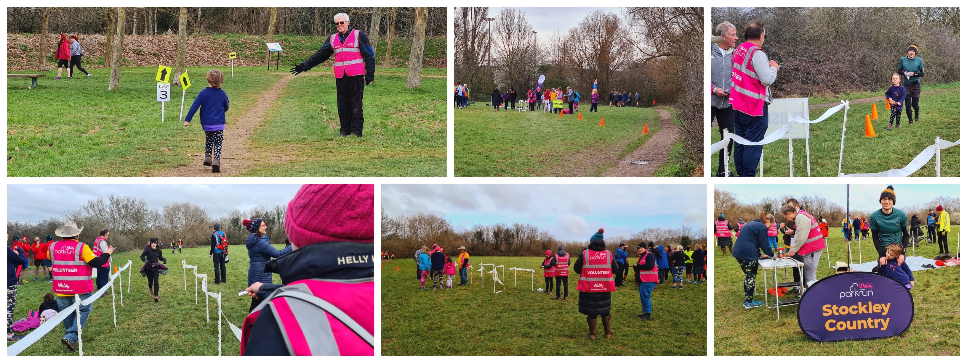
During our visit, there were plenty of arrows marking the course and the marshals were positioned in all the right places - they were extremely friendly and offered lots of encouragement. With the two laps complete, the finish is found on the grass next to the football pitch back at the original meeting point. Barcode scanning takes place immediately after and once the tail walker comes through the finish line everything is packed away and the event is over. There is no cafe within the country park, so no obvious place to congregate post-event. The information on the official page suggests there may be a post-parkrun social gathering but no venue is listed. So after a quick play in the small playground, we hit the road back home.

I recorded the course with my Garmin, so you can see the route that was used for event number 7 on my Strava account. Whether this is the final version or whether there is still some tinkering of the start loop to come remains to be seen. That GPS data was used to create a course fly-by video using the Relive app, and that can be viewed on YouTube. The results were published a short while later and 206 people had completed the course. Finally a massive thanks goes to all the volunteers that put the event on.


Related Links:

My GPS data of the course (Event 7 / 25 Feb 2023)
The Relive video of the course (Event 7 / 25 Feb 2023)


With Me Now Podcast (Containing the profile of the event / 8 March 2023)


Sunday, 12 February 2023

Shorne Woods parkrun

Roughly halfway between Gravesend and Rochester, in Kent, is the parish of Shorne, which is home to around 2,500 people. The name comes from the Old English word 'Scoren' which effectively means 'a steep place', and in early records the village had been recorded as Scorene.


The land is largely rural, consisting of Shorne Marshes (a Site of Special Scientific Interest) at the northern end, where the parish meets the bank of the River Thames. Agricultural fields account for most of the central area. The parish extends as far south as the famous Roman road, Watling Street (now the A2). The southern end of the parish contains the village of Shorne and some areas of woodland, which includes Shorne Wood, Brewers Wood, Brummelhill Wood and Randall Wood. This southern part of the parish is the focus of this write-up.

The first small manor in the area (c.1108), possibly called Rundale, was in the name of Smalesman de Schornes. The area had become home to the de Cobham family by 1202 and they resided in Randall Manor which stood in what is now Randall Wood, just to the south of Shorne village. The de Cobham family, and in later years, other tenants, resided in the house until around the mid-1500's. The house is thought to have been dismantled in the 1580's in order to provide building materials for the nearby Cobham Hall, which was being rebuilt by the Baron Cobham.


Cobham Hall later passed into the hands of the Bligh family who later became the Earls of Darnley. The hall had (and still has) it's own landscaped grounds and deer park. The woodland containing the ruins of Randall Manor was also part of the estate. During the second world war parts of the woodland became home to an Army camp. A RAF camp was established at Laughing Water at the far south-west corner of Shorne Wood for groundcrew working at the nearby RAF Gravesend. From the 1920s until the 1970s part of the woodland called Furzy Leas Wood was used for the extraction of clay to supply the local cement industry.

In 1982 Kent County Council bought Shorne Wood and opened it as a Shorne Wood Country Park. The council subsequently bought Randall Wood and Brewers Wood and these three combined woods now form Shorne Woods Country Park. The present-day country park covers an area of 292 acres and features woodlands, wetlands and meadows. The main central hub, containing the visitor centre / cafe, playground, toilets and car park is located in the largely flat area which would have been the clay pit - it is now known as Furzy Leas Meadows. Had the clay extraction not taken place, this area would still be a hill (Clay Hill) with the ground level being around 15-20 metres higher than it is today.


On 30 March 2013, the country park became home to Shorne Woods parkrun. This is a free, weekly, timed, 5km event put on by volunteers and all abilities are welcomed. I had taken part in this parkrun a few times since its inception (2014 and 2015), but returned in 2023 to try out the latest version of the course and to produce this updated write-up. For most people, travelling to this venue is going to mean arriving in a vehicle, as the public transport links are not great.

The car park can hold somewhere in the region of 250 vehicles and has a 2 metre height restriction. There is a charge to use the car park, which on Saturdays is £3.30 for the whole day - there is no further charge to access to country park. Payment can be made by machine using cash or card, or by using the paybyphone app, but please note phone signal and data connection can be intermittent in the park (however, you can pay right up until midnight). I had read loads of poor reviews about the app, so I played safe and paid with my debit card at the machine. There is also a car park season ticket (£57 for 12 months at time of writing) which covers all of Kent's country parks. From a parkrun point-of-view, this would also cover car parking at Lullingstone parkrun and Pegwell Bay parkrun.


If attempting to reach the venue by public transport, the closest train stations are Sole Street (to the south) or Higham (to the north east). They are both three miles away from the country park and the direct walking routes both feature significant stretches of country lane with no pavements, so they are not ideal. From what I can see, the bus services which stop outside the country park are the 416 and 417 Redroute Buses, but the services seem quite sporadic, so you'd need to do a bit of research to see if that option would work. Finally, cycling is a genuinely decent option if you can make it work. Alongside the A2 is a shared-use foot/cycle path which links into Dartford to the west (taking in the Cyclopark parkrun course on the way) and to Rochester to the east. There are cycle racks in the car park.

The main visitor centre and cafe building is quite interesting. It was designed to be eco-friendly. The Sweet Chestnut wood used for the main structure was sourced locally and the building itself is powered by a wind turbine, has a biomass boiler and rainwater recycling facilities. It is here that you will find the first toilet option. The meeting point for the parkrun is adjacent to the car park, next to a separate toilet block, and to be fair this is probably to most convenient of the two. The briefings take place here before everyone heads down the steps and over to the start line.


As you may remember from the earlier points in this write-up, the original meaning of Shorne is 'a steep place', the clay extraction was done on a hill, plus there's also an area of the woods called Caradiac Hill (seriously, there is). With all that in mind, it would come as no surprise if I was to talk about how hilly the course is... But it's not hilly at all. The team here have taken the sensible approach and kept the entire course relatively flat. This is brilliant for keeping the event inclusive to all abilities. 

The course uses the well established paths that make up the more central areas of the country park, so underfoot is mostly hard surface. Even so, in the winter things can still get a bit splashy and there can be some mud. Road shoes would quite likely do the trick, but the more cautious participant may prefer to use trail shoes. The course is totally fine for buggy running. On previous visits, I noticed this had been quite a popular venue for canicross runners, but this time around I didn't see any. I suspect parkrun's policy change on waist harnesses has been responsible for their absence.


Over the years, Shorne Woods parkrun's course has been tweaked a few times. There was a time when there was a two-and-a-half lap summer course and a three lap winter course. The latest configuration is an anti-clockwise three lap course and this is planned to remain the same throughout the whole year. Just note that the first lap is ever-so-slightly different to laps two and three. The start is contained within the regular-width tree-lined country park path, just behind the cafe. So it can be a little tight to begin with, but the field soon spreads out.

The course is extremely well marked out, with arrows, cones and marshals at all the important points and junctions. The route is almost always within the woods apart from a short section next to the playground which is within an area of open grass. The slight difference on lap 1 is a new out-and-back section which heads 150 metres off into the woods off the main loop. This helps make up the bit of extra distance that was lost from previous versions of the course when the playground was redesigned, resulting in the loss of a bit of previously-used footpath.


It's a really enjoyable course to navigate. There are only a few sections of straight path, and the rest features many different styles of meandering paths, with both shallow and tight turns. My favourite of which is the tight combination of alternating left and right turns towards the end of each lap. There are a few very gentle undulations around the course. I'd say it's just about the right amount to keep things interesting without being too troublesome to your finish time. Once the three laps are complete, the course continues back into the open grass area where the finish funnel is just on the path to the right-hand-side (in the summer it may be on the grass).

Unusually, barcode scanning does not take place right at the finish line. The barcode scanning volunteers are located just up the path outside the car park. The post-parkrun social and refreshments take place in the park's cafe where they serve all the usual drinks and snacks. They even have a pizza oven and I understand pizzas are available from midday. The results for event 441 were posted online a short while later and 182 people had taken part, very close to the official average which, at the time of writing, stands at 187.6. My GPS data of the course and the Relive course fly-by video are both online to view if you would like to see more detail.


After the parkrun we spent some time at the playground before heading off on a walk to explore the woods. We found the site of Randall Manor, followed the sculpture trail, headed to the top of Cardiac Hill, found many of the ancient trees and a Faerie Ring, wandered around the sensory garden and explored the small Arboretum.

It was a lovely day out and we are baffled as to why we'd left it so long since our last visit. Somehow I've only ever been to this parkrun in the winter, so the next time I visit, I'll make sure it is summer. I'd really like to see the place when the trees are in full leaf.


Finally, I'd like to add a huge thanks to all of the volunteers who made us feel so welcome.


Related Links:


Sunday, 5 February 2023

Bushy parkrun

Bushy Park, in West London, covers an area of 1,100 acres which makes it the second largest of London's eight Royal Parks. It sits wholly within the London Borough of Richmond-Upon-Thames and is nestled in-between the localities of Teddington, Hampton, Hampton Hill, Hampton Wick and Molesey. The vast size of the park means that each of the five localities' boundaries all cover sections of the park. It is, as you'd expect, steeped in history.

The land is known to have had settlements as far back as 4,000 years ago, and a bronze age barrow and burial mound was found and excavated in 1854. The most significant of the finds seems to have been a bronze dagger which is now apparently kept in the British Museum. Over the years, the land was used largely for farming, with a small section of land enclosed around 1491. In 1514 construction of Hampton Court Palace began just to the south. The owner of Hampton Court at the time, Cardinal Thomas Wolsey, began enclosing (some say it was appropriated) further parcels land that now make up the park.

bushy park / hampton court


In 1529, Hampton Court Palace came into the possession of King Henry VIII. He established the area as a deer-hunting park. Initially it consisted of three separate areas, known as Hare Warren, Middle Park and Bushy Park. Henry had plans to create an extensive navy, so had thousands of acorns planted in order to provide the timber for the ships. The name Bushy (or Bushie) is said to come from the thorny bushes that were placed around them to protect them from the deer.

King Charles I created an artificial water channel called Longford River during 1638/9 - its purpose was to capture and transport water from the River Colne to Hampton Court to supply its water features, it is 19km long and it flows through the park where it also feeds Bushy Park's ponds and the formal water garden. Within the water garden is the Grade II Listed Brew House; beer was produced here for the residents of one of the park's grand houses, Upper Lodge, at a time when beer was safer to drink than water. In 1702, King William III died from pneumonia after sustaining an injury when he fell from his horse after it had stumbled on a mole's burrow in the park.

water gardens / bushy house / upper lodge / shaef plaques


In the early 18th century, the park gained its most well-known formal feature with the addition of the picturesque, mile-long Chestnut Avenue (originally called Great Avenue). It was designed by Sir Christopher Wren (designer of 54 London churches including St. Paul's Cathedral), and served as a grand approach to Hampton Court Palace. Towards its southern end is the Diana Fountain, which features a polished bronze statue of a goddess surrounded by four boys, four water nymphs and four shells. Opinions vary over who the statue actually honours, it is sometimes linked to the Roman Goddess Diana, while other sources say that it honours the nymph Arethusa. For the record, it definitely has nothing to do with Princess Diana. The fountain had previously been installed at Somerset House by Charles I for his wife Henrietta Maria, before being relocated to Hampton Court Gardens by Oliver Cromwell. It has been in its current location since 1713.

It was around this time that the three separate park areas are thought to have started to be known collectively as Bushy Park. The end of the 18th Century marked the point where the park first became open to the public. This was on the orders of King William IV.

diana fountain


A couple of large houses sit in the northern part of the grounds, these were originally called Upper Lodge and Lower Lodge. Upper Lodge retains its name and is next to the park's formal water gardens, as mentioned above. Lower Lodge was originally built in 1685, but later redesigned and renamed Bushy House. This was home to several notable people including Prime Minister Lord North and King George IV, who is said to have been in residence at the time he became King. In later years the exiled Prince Louis of France took up residence here. It finally ended up as the National Physical Laboratory whose work includes the first working atomic clock as well as pioneering work in the world of computing including one of the world's first working computers (designed by Alan Turing) and the development of packet switching. The NPL also maintains the UK's primary standards of measurement and was involvement in the development of the infamous 'bouncing bomb'. 

Within the grounds of Bushy House is an apple tree which was grown from a section of Sir Isaac Newton's original apple tree (the one that helped him with his work on gravity). Sadly this area is not generally open to the public, but the NPL sometimes have open days where you may be able to see it. Continuing on this theme, a batch of seeds from one of the original tree's apples went to space with British astronaut Tim Peake. In 2020, Bushy Park was chosen as one of the sites where one of the space saplings would be planted. As of January 2023, it still hasn't been transferred here. However it is planned to be protected by a dome and will be located within the Woodlands Garden.

bushy parkrun


Over the years the park had gone from being common land to being totally enclosed, and with the addition of the brick wall, public access was now impossible. A famous story is that of Timothy Bennett, a local shoemaker, who successfully fought for the restoration of a public right-of-way through the park. This path still exists and is named Cobbler's Walk in his honour. It runs east-west connecting Hampton Hill to Hampton Wick. There is a memorial to him next to the Hampton Wick gate. It was during Queen Victoria's reign that the park was fully opened to the public.

During World War I Canadian troops were based in the park and the King's Canadian Hospital was established in Upper Lodge. During World War II, Bushy Park became home to the Supreme Headquarters Allied Expeditionary Force (SHEAF) whose commander was General Dwight D. Eisenhower. 8,000 American troops were located in the north-east corner of the park in the USAAF base called Camp Griffiss, which was named after Lieutenant Colonel Townsend Griffiss; the first American airman to die in Europe after the US entered the war. The top secret plans for Operation Overlord (Battle of Normandy) were made here which of course involved the D-Day landings. After the war some of the buildings were used as temporary accommodation for local residents and as Bushy Park High School before being demolished in the early 1960's.

the start


Bushy Park also has a long history with sports, most notably rugby, cricket and hockey. It is currently home to Teddington Rugby Club and four Cricket clubs. It was one of these clubs, Teddington Cricket Club, whose members were looking for a winter activity, so in 1871 devised the rules for a game called hockey. These are the rules that form modern-day hockey. On the western edge of the park is Hampton Pool, this is a heated, outdoor pool which is famously open 365 days-per-year. In 2012 Chestnut Avenue formed part of the Olympic Games Cycling Road Race route. The local area is also a very popular place for elite long-distance runners to live and train, I understand this is linked to St Mary's University which is well-known for producing world class athletes.

The modern day Bushy Park is still a deer park, providing home to around 320 red and fallow deer. The park now has a children's playground, a cafe called The Pheasantry and lots of wonderful areas to explore. A few areas have undergone refurbishment in recent years including the Diana Fountain and The Water Gardens. The majority of the park's terrain is made of open areas of natural grassland, bracken and trees. The park lost around 1,300 trees during the Great Storm of 1987, but there are of course many that survived that night. Around 200 of the remaining trees are classed as veteran (the highest number in any of London's parks), with 94 of these designated as ancient. In 2015 the park was designated as a Site of Special Scientific Interest. The Longford River still flows through the park and it feeds the ponds and the formal water garden. The park also contains Europe's longest avenue of Lime trees, which, I hear, was created in 1622.

first section of the course


On 2 October 2004, the park became home to a small weekly event called Bushy Park Time Trial. In October 2008 the name changed to Bushy parkrun. This park is of course the home of parkrun, and the story of how it began is very well known throughout the parkrun world, so I won't go over it again here. The event takes place over a 5 kilometre course on the eastern side of the park, and is open to all abilities including walkers. In fact these days, walking is very much encouraged and actively supported with the addition of the parkwalker volunteer role. You'll be very welcome no matter how you decide to participate.

This was my second visit to Bushy parkrun, the first having been almost ten years earlier. On that occasion, I cycled from Central London and secured my bike to the bicycle rack at the main car park. For the 2023 visit (my daughter's 100th 5k parkrun), we went as a family so we used the car. The main car park (free of charge), just next to the Diana Fountain is the obvious place to park, but you do need to arrive nice and early to secure a space here - access to this car park requires entry via the Hampton Court Gate at the southern end of Chesnut Drive. For most of the year, the vehicle gates open at 6.30am, but during the deer culls, which take place intermittently from September through to December, the vehicle gates open at 8am. Further details can be found on the Royal Parks website.

around the course - cobblers walk


An alternative car park exists within the park and this can be found near the Pheasantry Cafe. It is also free of charge. Access to this car park is via the Teddington Gate vehicle entrance which is at the northern end of Chestnut Drive. This is a good option if you are planning to go to the cafe afterwards. Another option is The Hampton Court Green car park, which is outside of the park, plus there is some limited on-street parking on Hampton Court Road. These both require a fee to be payed. For other free parking options, you may be able to find some on-street parking to the north of the park, in Teddington. To the south, there may be some restriction-free roads on the other side of the river. The Hampton Wick area, to the east of the park, looks to largely be residential parking at all times, so avoid that. Finally to the west of the park, in Hampton, there seem to be some options.

Using public transport is an advisable way to travel to this venue. It'll remove the stress of finding a parking space. Hampton Court, Teddington, and Hampton Wick Train Stations are all nearby. If travelling from Central London, the trains that run from Waterloo to Teddington and Hampton Wick seem to be the more frequent option. There are different routes in use from Waterloo, so some reach Teddington first, then Hampton Wick while others reach them the other way around. Another option should you wish to avoid on-the-day travel is to stay overnight nearby. I hear the Teddington Travelodge is a popular option (The Travelodge website quotes £5 for 24 hours of car parking in their car park).

around the course


The meeting point for the parkrun is just to the east of the Diana Fountain, not far from the main car park. The toilets are located nearby, and can easily be found next to the playground. There are also toilets located at the Pheasantry Cafe. Bushy parkrun is the original and largest parkrun in the UK. It regularly has over 1,000 participants (mostly in the range of 1,200 - 1,800), so when you arrive it'll be pretty obvious that you're in the right place. The main briefing takes place at the start line, and as you can imagine it is quite a sight. In order for all participants to hear, the briefing is done via a PA system.

Please bear in mind that the deer that reside in park are wild animals and need to be treated with caution and respect. There are some general deer safety guidelines plus some extra rules for dog owners on the Royal Parks website.

The parkrun takes place over a single anti-clockwise lap, although technically it's a point-to-point course as the start and finish do not actually join to create a full lap. It is contained wholly within the section of the park that falls within Hampton Wick. The terrain underfoot is a mix of fine gravelly path (this surface is known as hoggin), but there are also sections of tarmac and grass. Road shoes are fine in dry conditions, but my personal preference would move towards trail shoes during the particularly wet times of the year.

around the course - chestnut avenue / cobblers walk


I understand this course is the third different permanent route to be used at Bushy parkrun (but I hear there may have been other variations). The first was used from 2004 until 2006, and the second version from 2006 until changing to the current course in 2015. The park is perfectly flat, with not even a hint of any hills. Buggy running is totally fine here, just watch out during the first kilometre as it'll be very congested.

The opening stretch is on grass, at the eastern end of Lime Avenue (right next to the playground). It's super wide which allows for the high number of participants to line up and get off to a good flowing start. After a few hundred metres the course joins the hoggin path which runs alongside The Royal Paddocks, I understand this area is used by the Sovereign for stabling and grazing. The route then passes the Hampton Wick Royal Cricket Club at the south-east corner of the course. It then heads north past the Hampton Wick Gate and the Timothy Bennet Memorial, before turning and heading towards the centre of the eastern-half of the park, using Cobbler's Walk, where the course passes Leg of Mutton Pond.

around the course - the last kilometre (or so)


When reaching the central point, the course heads back out towards the perimeter path where it passes the Shaef Gate and the USAAF memorial. This area is also where the bronze-age burial mound was discovered. I understand the course passes over it. The next section heads south along Chestnut Avenue before turning to head back towards the centre of the course along Cobbler's Walk, but from the opposite direction. When the central point is reached, the course turns again passing Leg of Mutton Pond and then along the bankside path along the edge of Heron Pond. You may notice the course is shaped like an hourglass, but I've also read it described as a butterfly. The finish is found on the grass just after the pond.

The post-finish set-up at Bushy parkrun deserves its own mention. Owing to the very high attendances, Bushy parkrun uses a triple funnel where once crossing the line participants are queued in groups while waiting to be issued with a finish token. The marshals have this down to a tee, so don't be worried about the process - just pay attention and go where you are told to go and everything will work out just fine. When the numbers get very large they can switch a triple funnel system. It is all very impressive.

Barcode scanning takes place afterwards, and as you may expect, during the busy finish periods queues do form. To give you an idea how busy the finish funnel gets, during the busiest periods there are over 100 people crossing the line every single minute. That generally occurs in the 20-30 minute finishing time window, before starting to ease off after the 30 minute mark. Once all the participants and tail walkers have crossed the finish line, the team move onto the post-parkrun social/refreshments over at The Pheasantry.

post-parkrun queue / scanning


The results for event number 916 were posted online later that morning and 1277 people took part. Plus a staggering 69 people volunteered. I recorded the course using my Garmin and the GPS data can be viewed on Strava. I also used the Relive app to create a course fly-by video, so feel free to look at those if you would like further visual information on the route. I did notice that there is a note on the official course page which suggests the previous course may sometimes be called back into action. There are links at the bottom of this page which show the GPS and fly-by of that one.

With all the excitement of visiting Bushy parkrun over, we decided to explore the rest of the park, which as I mentioned above, is huge. The resulting walk covered a further 10.69 kilometres where we saw most of the historic features and areas mentioned at the beginning of this write-up. Until this point I'd only ever been in the parts used for the parkrun and junior parkrun (we were regular volunteers there for a bit, many years ago). It really is a lovely place to spend a full day, so if visiting, don't rush off home straight after the parkrun. A final mention should go to the team of volunteers who not only put on the event for their local community, but also welcome hundreds of Bushy first-timers every week, making their pilgrimage to the home of parkrun. Thank you.


Related links:


Wednesday, 1 February 2023

Hackney Marshes parkrun

Hackney Marshes covers 336 acres of low lying open land located within the Lower Lea Valley in the London Borough of Hackney. As the name suggests, it is historically an area of marsh land, and it formed due to the periodic flooding of the River Lea. Its human history goes back at least to 2,000 years. In Roman times a stone causeway ran across the area, and evidence of a Roman burial ground has also been discovered (possibly just to the west of the marshes). The area has a long tradition of being common land and was largely used for grazing.

The natural course of the River Lea flows along the eastern edge of the marsh and this once marked the border between Middlesex and Essex. There have, over the years, been a few buildings within the marshes, one of these was the White House Inn which was supposedly a place frequented by butcher-turned-highwayman Dick Turpin. It eventually developed a bad reputation (as if hosting highwaymen wasn't bad enough), being the source of late night anti-social behaviour. Finally its licence renewal was refused and it was demolished in 1913.

hackney marshes


The Knights Templar once owned the marshes and during this time watermills, for the grinding of grain, were constructed alongside the river. These mills were later used in the production of lead and, for a time, a newer watermill was used for boring gun barrels. The adjacent River Lea has long been navigable from Hertford all the way through to the River Thames, and improvements made in the late 1760's, where a new channel was created which is known as the Hackney Cut. This now forms the western border of the marshes.

In 1890 the marshes were purchased by the London County Council in order to protect the land from future development, and in 1893/4 Hackney Marshes officially opened to the public as a place of recreation. At around the same time, a flood relief sewer was constructed under the marshes, which lowered the risk of flooding. The adjacent areas had become more appealing for housing and for industry, and both were in high demand as London expanded. Despite the protection granted by the council, small parcels of land were subsequently used for development of housing such as the Kingsmead Estate and for the coal-fired Hackney Power Station (now demolished). 

hackney marshes parkrun


During the First World War the National Projectile Factory was based here, and then during the Second World War, the marshes were used as an Anti-Aircraft Battery location. The devastating effects of the Second World War on East London are well known. Once the war had finished, Hackney Marshes was used a location for the disposal of rubble from destroyed buildings. This rubble was spread across the area which was then covered with soil and grass. It is reported that this raised the level of the marshes by around 2 metres.

During the 1940's the Lesney die cast model factory was built in-between the Hackney Cut and Kingsmead Estate, next to Marshgate Bridge on Homerton Road. This is where the Matchbox toy vehicles were made between 1953 and 1982 (if you use street view on Google maps, you can view the 2008 capture and see the building). The Matchbox name has continued but under various owners, currently Mattel. The building itself stood until around 2009 when it was demolished to make way for a new residential development.

the start


The use of the marshes post-war became centred around a very specific sport; football. In fact, Hackney Marshes is known internationally as the spiritual home of grass-roots and Sunday League football. At one point in time it is said to have had around 120 marked football pitches, however due to further land being lost to developments, that number now stands at around 80 football pitches, mostly full-size, but there are smaller pitches for youth teams and for other variations like five-a-side. Plus there are a small number of other pitches set aside for rugby and cricket.

On 29 May 2010, the marshes became home to a free, weekly, timed, 5 kilometre event called Hackney Marshes parkrun. I originally visited this parkrun venue in December 2012 and took part on a very cold, frosty morning. That original blog wasn't very detailed, and the course has changed since, so in January 2023, I revisited along with the rest of the family to sample the new course and create a more in-depth write-up.

east marsh with the view across to the olympic park / marshal dog


If travelling to the venue on public transport, there may be a bit of walking involved. If using trains, the most pleasant option would be to alight at Stratford Station which is served by mainline, tube, overground and DLR trains. The journey can then be completed on-foot by walking through the Queen Elizabeth Olympic Park, which is linked to Hackney Marshes by a traffic-free path and footbridges. Other nearby stations are Hackney Wick, and Homerton (Overground), Leyton (Underground), and Lea Bridge (Mainline). The number 308 and W15 buses both stop on Homerton Road, just outside the car park area.

If arriving in a vehicle, there is a car park just off Homerton Road at the southern end of the marshes. It is free-of-charge and can hold somewhere in the region of 150 cars. Adjacent to the car park, outside the Hackney Marshes Centre, are a large number of bicycle racks - this is where I stored my bike when I visited in 2012. However most cycling parkrunners didn't seem to use these and had chosen to use an unofficial location nearer to the parkrun meeting point. There are toilets located at the Hackney Marshes Centre. This is the building that looks like a large rusty box. They were open before 8.30am.

the tarmac section


From the car park it is about a 200 metre walk to get to the start line. You just leave the car park and follow the riverside path, then turn right and cross the bridge. The meeting point, bag drop, start and finish are all located in this area which is called East Marsh. I recorded the route from the car park with my Garmin - The GPS data is on Strava.

The 5k takes place over an out-and-back style course, which could probably be more accurately described as a lollipop (although it doesn't actually look like one). As you may have gathered, the area is completely flat so this is a decent place to go for a good time. Underfoot is a mixture of 3 kilometres of grass and 2 kilometres of tarmac. Buggy runners would be fine on this course. When it comes to choosing footwear, there's a good chance that road shoes would be fine most of the time, but I went for my trail shoes as a precaution.

the football pitches / the view


There's a first-timers briefing, followed by the main briefing which takes place at the start line. The course starts on grass with a full lap of East Marsh where the participants circumnavigate the 11 full-size football pitches which occupy this section of the marshes, in a clockwise direction. You'll get a great view of the Olympic Velodrome and you can also see the 114.5 metre tall ArcelorMittal Orbit sculpture/viewing tower in the distance. The route then joins the path which goes over the River Lea via the bridge (this is where most of the cyclists had secured their bikes). Turning right, the course simply follows the tarmac path alongside the river. It meanders gently as it follows the thin strip of woodland that now separates the football pitches from the river.

For those at the very front or back, try to keep to the right-hand-side of the path when approaching fellow parkrunners. We were at the back and ended up on the left, so found ourselves in a position where we had to stop because there was a constant stream of parkrunners crossing our path. Also worth noting, the path is quite a popular route for cyclists so remember to keep an eye and ear out for approaching bikes. There was also a maintenance vehicle moving around, but the driver was very patient and respectful of all the pedestrians. I also thought that it was worth mentioning that, with Hackney Marshes being largely for sport, the area does lend itself to dog walking, so there were a relatively low number of dog walkers.

more football pitches / the last section of tarmac


At the half-way point, the route leaves the tarmac path and joins the North Marsh grass area (home to 49 football pitches) to begin the return journey. The course simply follows the natural route back adjacent to the football pitches. To assist with directions, there were some yellow flags to guide the way. This was particularly useful for us as we had lost visual contact with those in front of us. This grass section lasts almost exactly 1 kilometre before returning to the tarmac. I was expecting the grass to be muddier than it was, maybe it was just the day we visited, or maybe the drainage is just really good, but the only real mud was the very short sections when entering and leaving the grass.

In total I spotted four human marshals (plus a marshal dog) out on the course, all placed at the junctions where the course changes direction and they did a fine job of keeping everyone on the right course. The last section is just a retracing of the opening 1.5km but in the opposite direction. It starts with a final 500 metres on tarmac which finishes with a return crossing of the bridge. That leaves the one final kilometre where the course again circumnavigates the 11 football pitches, only now in an anti-clockwise direction. The finish is found in almost exactly the same spot as the start. As you'd expect, barcode scanning takes place on the grass straight after the finish.

the finish / barcode scanning


The event usually attracts around 300 participants every week, but we happened to visit on a particularly busy day. The results for event 585 were published later that morning and we had been part of a bumper crowd of 367 finishers. I'd like to make a special mention to the fact the course was very well marked and marshalled. On my travels I have noticed that established events can sometimes become complacent when it comes to these details. However, that certainly was not the case here. As always I had recorded the course with my Garmin and made a Relive fly-by video. The official post-event refreshments are noted to be had at the Hackney Marshes Centre. They have a fairly basic drink and food menu, and quite limited seating.

There are a couple of features of the marshes that I haven't mentioned that may be worth exploring post-parkrun. Firstly one of the southern areas that was previously football fields has been give over to nature and is called Wick Woodland. At the northern end are the former Middlesex Filter Beds which were used to filter water for drinking before modern-day solutions were developed. They are now a nature reserve. Also in the same area is an art installation called Nature's Throne. It is sometimes referred to as London's Stonehenge or Hackney Henge ('ackney 'enge). It consists of a number of large granite blocks arranged in a circular pattern - the blocks were originally the foundations of a Victorian Engine House. The central block is in the shape of a throne.

queen elizabeth olympic park


Sadly we didn't head north, as we had already decided to have a walk around the Queen Elizabeth Olympic Park so we headed off to the south instead. The Olympic Park was partially developed on land previously part of Hackney Marshes, and the last time we were there was in 2012 for the Paralympics. During our walk we went inside the velodrome, had some refreshments, saw the Olympic Rings and the ArcelorMittal Orbit, explored the riverside path and stopped at a couple of playgrounds on our way to the park's centre piece which is of course the stadium (officially now called London Stadium and home to West Ham United Football Club).

We returned to the car a few hours later after a brilliant morning out in East London. Finally, a huge thank you to everyone that helped to put on Hackney parkrun event 585.


Related Links:


My GPS data of the old course  (2012) (no longer in use)


Related Posts Plugin for WordPress, Blogger...