Sunday, 28 May 2023

Church Mead parkrun

Amersham is a town which sits within the Chiltern Hills, in Buckinghamshire with a population of around 15,000 people. The earliest records of a settlement here go back to at least Anglo-Saxon times when it would have been known as Agmodesham. Other versions of the town's name have been Elmodesham, Agmondysham, Amytysham and Hagmondesham. The name is said to derive from the Old English term meaning Ealhmunds Village. The early settlement was located within the valley of the River Misbourne and this is the part of the town which is now referred to as being Old Amersham or Amersham Old Town. The modern expansion is based around the railway line which arrived at the end of the 19th century and is known as Amersham-on-the-Hill.

amersham old town

The newer part of town has grown steadily since the turn of the 20th century thanks to its direct rail link into London which has made this a popular commuter town. As the name suggests, this part of town is up on the hill, and most of the buildings date from the 1920's onwards. Some of the houses were created as part of the Metro-Land project which saw surplus land owned by the Metropolitan Railway used for house buildings projects. A few notable buildings are the High & Over House, which is a grade II Listed building which was complete in the 1920's. There was also once an Art Deco theatre/cinema called The Regent, but sadly this was closed in 1962 and demolished to make way for a supermarket soon after.

Old Amersham is centred around its historic High Street, and this part of town contains over 150 Listed Buildings from various periods from pre-Tudor times onwards. It is said that the high street looks very similar to how it would have during the 1700's. The town was once owned by relatives of Sir Francis Drake, and the family still have links to the town. St. Mary's Church, which is the town's oldest building, was founded in 1140AD. The current building was built in the 13th century and it was further enlarged during the 14th and 15th centuries. The church occupies the site of an earlier Norman building of which a few sections still remain. The north side of the church contains the Drake family chapel and their family tomb is located in a vault directly below.

st mary's church / cemetery / church mead

The churchyard is home to some extremely rare tombstones called 'body stones' which have an unusual shape to them. Apparently the only other tombstones of this design can be found in Westerham, Kent. Next to the churchyard is a beautiful remembrance garden containing a war memorial and St Mary's Cemetery is located just beyond this. A notable burial in the cemetery is that of Ruth Ellis. She was convicted of murder and in 1955 became the last woman to be hanged in the United Kingdom. Additionally Church Mead (meadow) is a small, grassy area adjacent to the church and this lends its name to the town's free, weekly, timed 5km event called Church Mead parkrun.

The parkrun has been a feature of the town since 9 April 2022 when the inaugural event was held. I visited the town on 27 May 2023 and took part in event number 59. As I have alluded to above, the town has a train station and this is simply called Amersham Station. It is located within the Amersham-on-the-Hill part of town and is served by national rail trains running on the Chiltern Railways between London's Marylebone Station and Aylesbury, and also by the London Underground's Metropolitan Line. The station actually falls within the London Underground's zone 9, so it is possible to travel using an Oyster card despite being outside London. Once arriving at Amersham the last leg of the journey involves heading down either Station Road towards the Old Town (just over 1 kilometre).

start

There are also buses that pass through the old town, with the closest bus stops being on the main road near the large Tesco. Driving to the town is of course possible, and the closest car parking option is Amersham Old Town car park which is right next to Church Mead. The car park requires a fee to be paid and this can be done via the payment machine or by using the RingGo app. As an alternative, the High Street to the west of Old Amersham Market Hall is completely free of restrictions, so you can park for free for as long as you like only a few hundred metres away. For cyclists, I don't remember seeing any bicycle racks anywhere in Old Amersham, so it may be a case of looking around for a suitable place to park up. Finally there are public toilet facilities available within Amersham Old Town car park.

The meeting point for the parkrun is on Church Mead, just in front of the cemetery and adjacent to the river. The official course page advises parkrunners not to enter Church Mead via the Memorial Gardens, but instead enter from the car park, but access is also possible via the church yard. Both the first-timers and the main briefings take place here, but a special mention should go to the creative and theatrical presentation of the first-timers briefing on the day I visited. I hear this is a regular feature and it was certainly an interesting way to present it.

barley fields

The main bulk of the course is nestled into a large triangular patch of land which sits in-between the old and new sections of the town, and consists of two mostly-off-road, anti-clockwise laps. I understand it can get pretty muddy at times, so it is predominantly a trail shoe course. It is also hilly and has quite narrow paths. With all that in mind, it's not the most buggy running friendly course, so there is a note for buggy runners to contact the team for advice before visiting. Once the briefings are done, the parkrunners move onto the grassy area on the very edge of the car park to form the start line.

The opening section of the parkrun is likely to be quite congested so it is wise to self-seed appropriately. After weaving along the narrow path through Church Mead, the course crosses the river via the small stone bridge and then follows the cemetery's boundary wall around until reaching the wide open barley fields behind. This point marks the start of the lap. The route continues to follow the boundary of the cemetery, the elevation rising and falling gently until the end of the wall where the path continues alongside the River Misbourne for a short stretch. At the south-eastern tip of the course there's a left-hand turn and the route begins its long journey uphill.

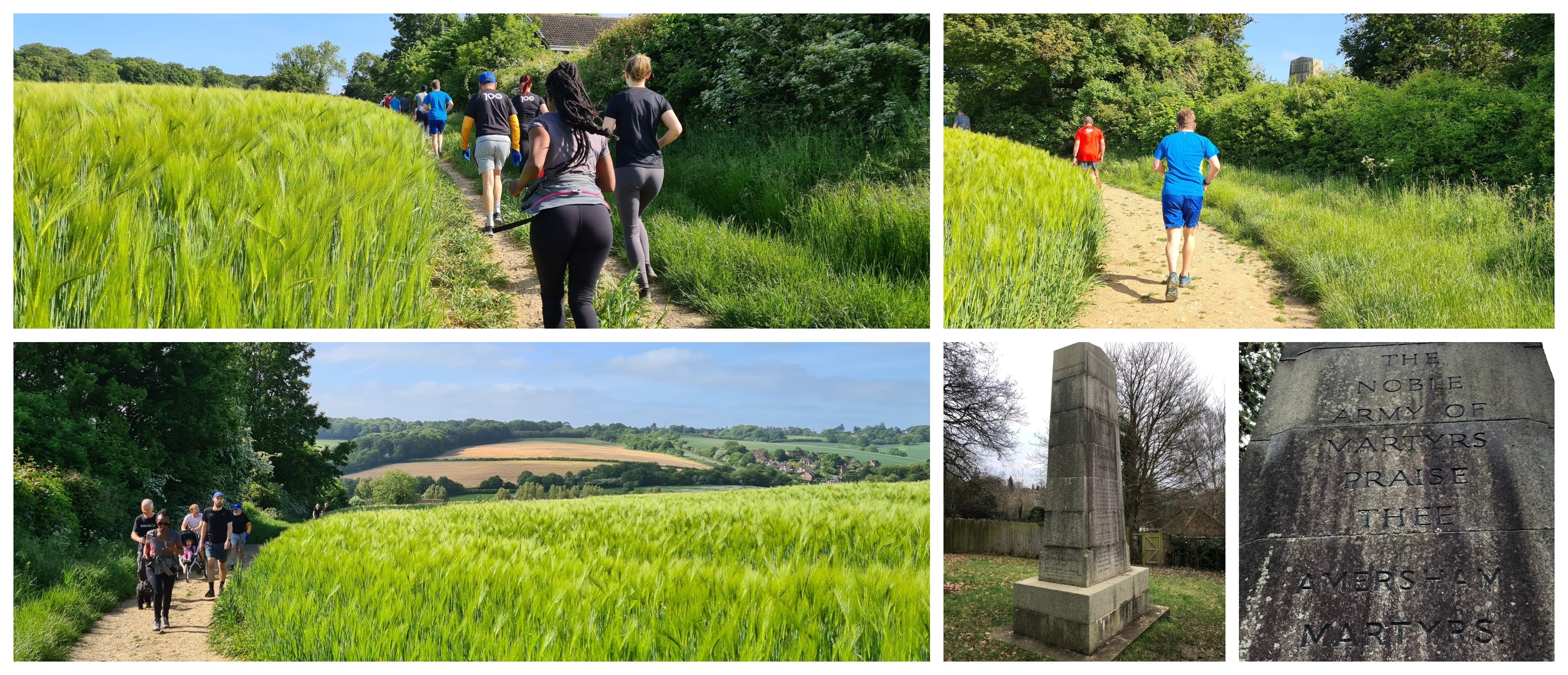
photos of the the amersham martyrs memorial courtesy of richard gower

The off-road path underfoot is embedded with chunks of flint, so care is required at all times. As the path works its way up the hill, there's a moment where the top section of a memorial stone can be seen behind the bushes. The stone is the Amersham Martyrs Memorial and it commemorates the seven residents of Amersham that were burned at the stake in the 1500's. They were Lollards who wanted to reform the Catholic Church, their main demand was to be able to read the bible and worship in English. The uphill slog continues up along this side of the fields until reaching a marshal at the entrance to a wooded area called Parsonage Wood.

The section in the woods begins with a slight dip in elevation, but the uphill theme is resumed shortly after. The surface underfoot continues to be precarious, as along with chunks of flint, there are also tree roots (and over the winter months a fair amount of mud) to deal with. On the day I visited I found that the lighting in the woods made it quite difficult to identify any potential trip hazards up ahead. In fact there was a lady who tripped and fell. The woods are quite beautiful and clearly very old. The highest point of the course is reached at the northern end of the course where it meets the adjacent road, Rectory Hill. After about 200 metres of some flat terrain, the course begins its descent.

parsonage wood

As the course descends there is a gully which runs along the path, which could also be a trip hazard, so watch out for that. The downhill section is shorter than the uphill, which of course means it is steeper. As the course exits the woods, parkrunners are treated to a fantastic view across the valley and onwards towards the hills and fields beyond. The path downhill is part tarmac so it is a sensible idea to stick to the smoother surface and avoid any potential trip hazards. At the bottom of the hill the course reaches the corner with the cemetery and a second, identical, lap begins.

At the end of the second lap, the course follows the cemetery boundary back around towards Church Mead where the finish is found in-between the cemetery and the river. After the finish line there is a small wooden bridge which can be used to cross back onto the main Church Mead grassy area where the barcode scanning takes place. Once all the parkrunners have completed the course and all the signage and marshals have returned, the team heads over to Seasons Cafe for the post-parkrun refreshments and social. They have a wonderful selection of breakfasts, cakes, pastries and drinks.

the view

I recorded the course using my Garmin and the course data can be viewed on Strava. The data was used to create a course fly-by video using the Relive app, and that can be viewed on YouTube.

The results for event 59 were published later that morning and 117 people took part. That is a little higher than the average, which is currently 100.5, but it's also not unusual for the turn out to be in double figures. It's a really nice, scenic, challenging course. I'd like to extend my thanks to all of the volunteers involved in putting the event on and making my visit a very enjoyable one.

finish / church mead


I continued the rest of my morning by exploring the Old Town. St Mary's Church, Old Amersham Market Hall, and The Kings Arms pub are notable buildings which I made sure to see. The Crown Hotel was used as a filming location for a scene in the 1994 film Four Weddings and a Funeral. While on the subject of filming, the town was also used in Midsomer Murders, Sky TV's Midwich Cuckoos, the 1973 Metro-Land documentary and the 1997 Metroland film. Then there was this from Taskmaster which was filmed on Church Mead. Lastly the BBC sitcom Cuckoo has many scenes filmed in town, and there's even a choreographed umbrella dance scene in the Memorial Garden. 

While wandering around I couldn't believe how many locals stopped to talk to me. I think this may be the friendliest town I have ever visited!


Related Links:


Sunday, 21 May 2023

Thames Path parkrun, Woolwich

Woolwich [Wuul-ij] is a district in the Royal Borough of Greenwich, London. The area's name is thought to indicate that the settlement was orignally a trading place for wool. The Anglo-Saxons called it 'Uuluuich', and they first settled here on the south bank of the River Thames in what is now known as Old Woolwich or Woolwich Central Riverside. The land within the ancient parish of Woolwich extended across the Thames where you will still find a small area called North Woolwich (now part of Newham). The two halves of the ancient parish have been connected by a ferry service since at least 1308 and of course this connection is maintained in the form of the modern-day Woolwich Ferry which came into operation in 1889 and has always been free-of-charge. There is also a foot tunnel which opened in 1912.


The area remained a fairly small settlement in Kent, with likely industries thought to be small-scale shipbuilding and repair, pottery and milling. This all changed when King Henry VIII established a dockyard here called  'Woolwich Dockyard' or 'The King's Yard' in order to begin work on the King's naval fleet. His flagship 'Henry Grace a Dieu' or 'Great Harry', at the time the largest and most powerful warship in the world, was built here along with many other warships. In fact, Great Harry also finished its service at Woolwich in 1553 when it was accidentally destroyed by fire. HMS Beagle which carried Charles Darwin around the world was also built here. The industrial presence was subsequently expanded with the addition of a gun yard and a rope yard.

Gun proving took place locally in an area called The Warren, and this developed into military research, armament and storage establishments. In 1805 these were brought together by King George III and named the Royal Arsenal. The arsenal produced all kinds of weapons and military equipment from small guns, bullets, bombs, through to field guns, mortars, tanks and torpedoes. Gunpowder would have been delivered via barge from the Royal Gunpowder Mills in Waltham Abbey (now home to Gunpowder parkrun). In later years it was even involved in the development of the UK's first nuclear weapon. There were 147 miles of railway tracks laid within the 1,285 acres of grounds which helped move the materials between workshops.


In 1886 munitions workers who worked in the Royal Arsenal formed a football team called Dial Square (named after one of the workshops), but changed their name to Royal Arsenal the following year. In 1891 they became known as Woolwich Arsenal and were the first London football club to turn professional. They moved to north London in 1913 where they are now known simply as Arsenal. The club retains a link to the Royal Arsenal through their crest which still features a cannon. The Royal Arsenal's peak came during the first world war when around 80,000 people were employed on the site which covered 1,285 acres. The history here is so vast that I cannot cover it all here, but if you are interested there is a brilliant website called Royal Arsenal History

The military link with Woolwich has been strong for hundreds of years and in the 18th century large barracks were constructed and these eventually became known as Woolwich Garrison. The dockyard eventually closed down as it was unable to compete with other dockyards which were building the newer ironclad warships. By Victoria times part of the riverside area known as Old Woolwich had become a slum and the worst part of this slum was named the dusthole. It was given that name due to the dust from the coal wharves which had been established. The riverside area also became home to a gas company and a power station. The first and second world wars saw a huge uplift in the production of ordnance, but in times of peace the factories switched production to train carriages and other items like knitting frames. The industrial nature of Old Woolwich continued until the late 20th century when the power station and other industries gradually closed down.


Woolwich has sadly been in the news as a result of terrorism on more than one occasion. Firstly, in 1974, the Provisional IRA detonated a bomb in a local pub, killing two people. Secondly, a soldier, Lee Rigby, based at the Royal Artillery Barracks was murdered by Islamic terrorists in 2013 on his way home to the barracks. Woolwich also has quite an interesting claim to fame, as it became home to the UK's first-ever McDonalds in 1974. While on the subject of retail establishments, I worked in the Woolwich branch of Iceland Frozen Foods during 1999 and 2000. Since the mid-2000s the Old Woolwich area has been undergoing a huge redevelopment project, which really gathered pace when it was announced that Woolwich would be gaining a new train station as part of the Crossrail project (Elizabeth Line).

The redeveloped area contains a mixture of both new and repurposed buildings - many of the new apartment blocks have been named after ships built at the dockyard. There is a very strong sense of its history and as you walk around there are field guns, cannons, historic buildings, steam hammer bases, cannon balls and a statue of The First Duke of Wellington who was Master General of the Ordnance 1818-1827.


It is largely residential but also contains shops, bars, restaurants, gyms and everything else this newly established community could need including a twice-per-month farmers market. There is also the Woolwich Works Creative District which is a cultural hub with spaces for performances, galleries and studios. As of 6 May 2023 it also has its very own free, weekly, timed, 5km event called Thames Path parkrun, Woolwich. The main meeting point for the event is at James Clavell Square (named after the screenwriter, director and World War II veteran and prisoner of war) where there is a bag drop area and the first-timers briefing is held. Fittingly, at the meeting point is a sculpture called 'Assembly' which is intended to represent a group of people coming together.

The meeting point is conveniently located just a stone's throw away from the new Elizabeth Line station, which is simply called Woolwich. However it is not the only station. Just across the road near the main shopping area, you will find Woolwich Arsenal Station and this is served by Southeastern trains that run between central London and Dartford/Gravesend, and also by the Docklands Light Railway (DLR)(only two stops from the London City Airport). The platform of the DLR station was used in fifth Bourne film where it was transformed into Athens metro station. There is a third station called Woolwich Dockyard, this is also served by Southeastern trains but is further away. Woolwich is also served by an abundance of buses, and it also has Woolwich (Royal Arsenal) Pier which is served by the Uber Boat service. Sadly, from what I can see the earliest Saturday boat service doesn't run in time to make it viable for travel to parkrun. However it could provide an interesting post-parkrun journey into central London.


This is one of those venues where public transport is the best way to arrive, but if you do happen to use a vehicle, the car parking options are really well covered on the event's official course page. In summary, there is no on-street visitor parking within the new developments. The remaining options are the New Warren Lane car park, Cannon Square car park or one of the other town centre car parks, and these would all incur a charge. For some free parking the Woolwich branch of Tesco apparently allows up to three hours free-of-charge (accessible from Woolwich New Road). If you look carefully you may even find some restriction-free on-street parking further along the riverside to the east. Should cycling be of interest, this venue has great links via the Thames Path, which is a designated cycle route, going both East and West, plus the Woolwich foot tunnel (open 24 hours, but bikes must be pushed through) makes it really easy to access from the other side of the river. There are bicycle racks right next to the pier. For anyone travelling from further afield who may require an overnight stay, there is a Premier Inn within the new development and a Travelodge across the road within the main shopping street.

The main public toilet facilities used to be across the main road on Beresford Square, which has been home to Woolwich's main market since the 1600s. These toilets have now been demolished (Nov/Dec 2023). You would have passed them on the way to the meeting point if you arrive on the DLR or Mainline Rail. The current arrangment is that Woolwich Works (next to meeting area) open their toilets from 8.30am for parkrunners. Alternatively there's always the UK's first branch of McDonalds on Powis Street or the large Tesco on Woolwich New Road. As the name of this event suggests, this parkrun takes place on the Thames Path. The majority of the Thames Path is part of the Thames Path National Trail, which runs from Trewsbury Mead in the Cotswolds all the way to the Woolwich Ferry. The section which the parkrun uses is an extension, which, in total, runs all the way through to Crayford so is not part of the National Trail. An interesting fact is that it forms part of the brand new King Charles III England Coast Path - South East.


The parkrun itself starts about 400 metres to the east of the meeting point, just next to the remains of a historical landmark called T-Jetty and just on the other side of what I believe may be part of the entrance to one of the old dry docks. The main briefing takes place here. The course is a single out-and-back but with a nice surprise at the far end, but we'll come to that later. Underfoot is mostly tarmac, but there are also sections where the path changes to a rougher, looser gravelly surface. However this is definitely a course for road shoes at all times of year. There's a special note regarding buggy running, and that is that while regular single width buggies are fine, double-width buggies are not suitable for this course.

The usage of the River Thames has historically been quite different depending on the location. The further west you travel, the more genteel it becomes. This part of the river is on the eastern side of London, so it would have been, and still is, more of a working river. To that effect, the pathways and surroundings are harsher, than you will find, say, on the Thames Path at Richmond or Oxford. You certainly won't spot anybody punting on the river in Woolwich! The parkrun starts next to the T-Jetty and very soon after passes the J-Jetty; both remnants of the area's previous life as the Royal Arsenal. The parkrunners keep to the left at all times, there are also points where the path is divided into lower and upper sections. On the way out the course sticks to the lower path which is the one closest to the riverside.


The opening section is a fixed width which has a safety railing on the left and some small bushes and the retaining wall for the upper path on the right, so there could be some congestion to start with, especially on a busy day. After a short stretch the safety railing ends and is replaced by a brutalist concrete riverside wall on both sides of the path. You can't see it from the parkrun course on the way out, but a water channel runs under the footpath. This was the entry point for the canal system (built 1812-14) that was used to deliver supplies to the Royal Arsenal. The Grade II Listed Broadwater Lock and Swing Bridge are located in this area. The swing bridge was installed in 1876 to allow the site's railway line to cross the canal. The Lock and Bridge have recently been renovated, but there is a risk that housing developments could see the remaining section of the historic canal filled in.

Continuing on the outward-bound stretch the brutalist riverside wall concrete ends and is replaced by some trees and bushes. At the same time there is a gate to pass through and the surface underfoot changes to the gravelly surface. It's not exactly like what you'll encounter at the other end of the Thames, but the path meanders along nicely through the tree cover. If you keep your eyes peeled you may be able to spot an old wooden slipway, again this was once part of the Royal Arsenal. By this point the route has taken the parkrunners into West Thamesmead where the course now leaves the Thames Path and at 1.3 kilometres turns right into Gallions Reach Park via a gate which has a width restriction. Incidentally at this point, the course is directly in line with the end of the London City Airport runway, which is just across the river. Every now and then you may hear and see a place taking off.


Gallions Reach Park is a relatively new addition to the local area, but the land was also part of the Royal Arsenal and there are still remnants of its past hidden deep within the bushes. The extended area contains a range of wildlife habitats including scrub, wildflowers, grassland, and woodland. My preconceptions about Thamesmead led me to assume that the park would be a little rough around the edges, but what I found was the complete opposite. The gloriously sunny morning probably helped, but this park was beautifully manicured with lush green grass and neatly spaced trees lining the path. Such a lovely spot to parkrun through.

The name comes from the Galyons family who owned large amounts of property on both sides of the river during the 14th century. This whole section of river 'Gallions Reach' is named after them. You'll also find many references to the name across in East London. The parkrun course only passes through a very small section of this area, but it is beautifully landscaped and covers 40% of the total percentage of the 5 kilometre course.


The path meanders around to this venue's pièce de résistance, called Gallions Reach Hill, but I understand the local West Thamesmead residents call it Teletubby Hill. It is one of six artificial mounds present within the park, which were created from left-over building materials when the local housing was constructed, then landscaped into these quirky features. So, in case you were not already aware, the course goes up to the summit of the largest mound where the parkrunners loop around a marshal and then head back down.

The path winds its way around the hill creating a spiral shape to this part of the course. From the base to the top is around 500 metres, so in total you spend a full kilometre on the hill. The top features a 360 degree view where can see the Barking Creek Flood Barrier to the north. To the east, the Crossness Sewage Treatment Works, and also the tower blocks overlooking Southmere Lake, constructed in the 1960s and was used as a filming location for the TV series Misfits and also for the film A Clockwork Orange. HMP Belmarsh is to the south with Shooters Hill in the far distance. Finally, you can see Canary Wharf by looking to the west.


With the hill out of the way, the course heads back towards the riverside and then onwards towards Woolwich. The return journey takes place on the upper section of the Thames Path which is a hard surface, and mostly paved, underfoot. It is split into a people-path and a cycle-path, so take care not to wander into the bike lane. It continues all the way back past the lock (where this time the swing bridge is visible), the jetties, the start area, and then the circular shaped building with a turquoise roof - I understand this is a ventilation shaft for the DLR which runs under the river into east London. The course then continues back to the original meeting point at James Clavell Square where the finish can be found. The barcode scanning takes place here and the official post-event refreshments can be had right next to the finish line in the cafe within Woolwich Works. If you don't fancy that, there are other cafes dotted around the immediate area. You could also pop over to the main Woolwich central shopping area where there is a Wetherspoons pub called The Great Harry or a wide selection of almost all the familiar high street coffee shops and fast food outlets.

I did of course record the parkrun course with my Garmin so you can check the course out in detail by viewing the data on my Strava account or you can watch the Relive course fly-by video which is on YouTube. The results were processed and published online a short while after. At time of writing the amount of participants is being heavily skewed by the high number of curious locals and parkrun tourists, so the average is higher than it will eventually be. Saying that, the section of the course that goes up the mound has very quickly become one of those quirky details that people just love, so I suspect that it will permanently continue to draw people to this event for many years.


After the parkrun we explored the area and found so many details and references to the area's past. There were a lot more original buildings than I was expecting and we also found more old cannons including some from Germany, France and Egypt (made in 1530) dotted all around. We also went back to see the swing bridge and lock in more detail, before finally heading back over to Gallions Reach Park where we went back up to the top of the mound to fully take in the view. Despite living only 15 minutes down the road, we had never considered spending time in Woolwich, but having the parkrun here has really opened my eyes to what an amazing history this place has. You can also walk along the Thames Path past the Woolwich Ferry and if you carry on walking you can see the Thames Barrier up close. Finally, I'd like to extend a massive thank you to all of the volunteers.


Related Links:


Sunday, 14 May 2023

Old Deer Park parkrun

Old Deer Park is an area of green space beside the River Thames in Richmond, in the London Borough of Richmond Upon Thames. It forms part of a chain of separate green spaces which include the Royal Botanic Gardens in Kew, and the grounds of Syon House which sits on the opposite bank of the river. The total area of Old Deer Park covers 360 acres of which 220 acres are leased for private sports use and the remaining 140 acres are open to the public.


The area that is now Richmond was previously called Shene and this came from the Royal Manor of Shene, which itself used to be part of the Royal Manor of Kingston. There has been a manor at Shene since about 1125. Please note that the Shene mentioned here is not the same as the modern day district of Sheen which is just to the east. Various royals lived in the manor house throughout the years, and in around 1360 the manor house was improved by Edward III and became Shene Palace. The English poet and author, Geoffrey Chaucer served in the palace as a yeoman at this time.

1383 saw Richard II became the first monarch to make the palace his main residence. However his wife, Anne of Bohemia died from plague at the palace a few years later. It seems that the distraught King then abandoned the palace where it was defaced and became a ruin or was demolished (information varies). Henry V was the next monarch to become involved in the palace. He had it rebuilt in 1414. In the same year Henry V also founded a Carthusian Monastery, called Shene Priory, and this stood within what is now one of the private sports areas of Old Deer Park.


The next big change came in 1497 when Shene Palace was destroyed by fire. The palace was occupied by a large number of the royal family at the time and most, including the 6-year-old future King Henry VIII, only just made it out alive. This led to Henry VII building a brand new palace, and the king decided to name it after his former title, Earl of Richmond, whose seat was Richmond Castle in Yorkshire. This of course meant that the area became the Royal Manor of Richmond. The palace would eventually be given to Anne of Cleves as part of her marriage annulment settlement with Henry VIII. In 1539 the Dissolution of the Monasteries Act meant that Shene Priory was closed down.

To the north of the palace, Old Deer Park was originally known as Newe Parke of Shene and during the 16th century was a favoured deer hunting spot for Queen Elizabeth I. Incidentally, Elizabeth I's godson, John Harington, invented the flushing lavatory, and the palace was one of the first buildings to have one installed. Elizabeth I died at Richmond Palace in 1603 and the parkland was formally made a Royal hunting ground by her succesor James I. King Charles I, who also enjoyed hunting deer, created a larger hunting ground, called King's New Park, in 1637 and this led to the original Newe Parke being renamed as the Old Deer Park. The King's New Park is now called Richmond Park, the largest of London's royal parks. After Charles I was executed, Richmond Palace was slowly demolished with the stones being used as building materials elsewhere. It was never rebuilt.


The royal connection with the land remained strong and a house within the boundaries of Old Deer Park called Richmond Lodge became the summer countryside residence of King George II. It then passed to King George III who had an interest in astronomy. He had an observatory (The King's Observatory) built in the park and this building went on to become a centre where scientific instruments, watches, barometers, thermometers etc, were tested for accuracy. This function passed to National Physical Laboratory (in Bushy Park) in 1910. It was also used to set Standard London Time before the responsibility passed over the Greenwich. The building is now Grade I Listed and is currently a private residence.

The parkland is still owned by the Crown and has been split-up into areas with different uses. Since 1892 the largest portion has been occupied by Royal Mid-Surrey Golf Club, which has two 18-hole golf courses. The foundations of Shene Priory are apparently located under the fairway of the 14th hole of the outer golf course. The rest of the park consists of various sports clubs (rugby, cricket, tennis, archery) which are based within another private area. The far southern area contains the 140 acres that are open to the public. This space is quite open and is used for sports and other community related activities. It is bordered by the Thames, the golf club, and the busy Twickenham Road. It is also the home to a Grade II Listed swimming pool, originally known as Richmond Baths but now called Pools on the Park.


In August 2010 the parkland became home to Old Deer Park parkrun, which is a free, weekly, timed, 5km event open to all abilities. I first visited Old Deer Park in January 2013 to take part in the event, and it turned out to be a very cold and wintery experience with the course covered in snow. I did however receive the warmest welcome I could hope for and I was even being cheered on by name throughout the event despite it being my first visit. Fast-forward to May 2023 and I finally returned to see what the park looked like without its winter coat on.

Travel options to reach the venue are pretty good. In 2013 I took the main nation rail train from Waterloo to Richmond Station, this station is also served by the London Overground and the London Underground. The onward walk is only around 500 metres. There are also a number of buses that serve the area. Cyclists can secure their bikes to the cycle racks in the park near the playground or at the swimming pool, or just use the wooden fence near the meeting point.


Please note that drivers are asked to not use the swimming pool car park, but to instead use the park's official parking area just on the other side of Twickenham Road. It is connected to the park by a footbridge and holds 285 cars. Parking fees are on the high side (Richmond Council's information page), but won't break the bank unless you're staying for an extended period. Payment can be made at the machine, by phone or via the RingGo app. An option for some free parking that has been brought to my attention is to park on the opposite side of the the River Thames (Ranelagh Drive) and use the pedestrian crossing over Richmond Lock and Weir to reach the park, which can be accessed from the Thames Path. Toilet facilities are available to parkrunners inside the swimming pool building (just tell the staff at the counter that you are taking part in the parkrun and they'll let you through).

The parkrun meeting point can be found just behind the swimming pool on the grass at the eastern side of Old Deer Park. The briefings take place in this area and everybody then walks across to the start area which is next to the tennis courts. The course is almost completely flat and takes place over a clockwise three-and-a-bit lap course which almost exclusively features grass underfoot. There is just one short section on a tarmac path each lap. It is worth bearing in mind that the park is used as a flood plain due to it being low lying and adjacent to the river, so its not uncommon for it to hold onto some water. Shoe choice will come down to personal preference, but I would go for trails in the winter or after wet weather. Buggy running is fine here, but please note that dogs are not permitted at this event.


The parkrun starts at 9am and the route is very simple to follow, as signage is present all around the course. The signage is made up of arrows at some points and elsewhere you will find permanent, wooden course marker posts. It is broadly speaking rectangular in shape with each lap being almost exactly one mile in length. The only real features to look out for around the course are the three obelisks that stand on the western side of the park. These were put in place as meridian markers to assist with King George III's observation of the 1769 transit of Venus from The King's Observatory. There is apparently an intentional gap in the trees, which has been created to maintain the observatory's historic sight lines. I tried to spot the observatory, but I just couldn't see it.

At the end of the three laps, there is of course a finish funnel to enter and this is located back at the original meeting/briefing point. Barcode scanning takes place at the end of the funnel. The post-event refreshments are held in the swimming pool cafe.


After the parkrun and a visit to the playground, we went off to explore the centre of Richmond. The famous and iconic Richmond Green and the adjoining quaint streets are only a stone's throw away. This spot is a must-visit location for fans of the TV show Ted Lasso, as many of its scenes are filmed around the green. Richmond Green has also been used in The Sandman Netflix series. Richmond itself has also been a filming location for National Treasure: Book of Secrets, Finding Neverland, A Fish Called Wanda, The Young Victoria, Bedazzled, and many other films.


There are also some sections of the Richmond Palace complex which have survived, so that's also another place we visited. The foundations of the palace are buried under the garden of Trumpeter's House and there was an episode of Time Team (series 5, episode 1) in which these were investigated. Richmond has a museum in the Old Town Hall (free entry) which contains a model of Henry VII's rebuilt palace, however on the day we visited the museum was closed as the staff were manning a stall at an event. so I sadly didn't get to see it. The Thames Path also provided us with a beautiful location for a walk along the river.


While we were exploring, our parkrun results had been processed and published online. There had been 158 participants at event number 580. The current average number for this event is around 140 or so during the good weather, but it can drop down to under a hundred during the winter. It's also worth noting that there is an alternative course (3 laps) which is sometimes used. My understanding is that the main reason for switching is usually when a circus or fairground is in town. When the alternative course is being used, the meeting point and finish shift over to the start area. The GPS data and Relive course fly-by videos of both courses can be viewed via the links below.

The volunteers and other regulars had made us feel so welcome, so a very big thank you goes out to everyone involved with the event for that.


Related Links:

My GPS data (May 2023)


The London parkruns (blog7t page)


Related Posts Plugin for WordPress, Blogger...