Monday, 29 August 2022

Wollaton Hall parkrun

Nottingham is a unitary authority that sits within the ceremonial county of Nottinghamshire, it was granted city status in 1897 as part of Queen Victoria's Diamond Jubilee celebrations. The early settlement was recorded in the Domesday book as Snotengaham. It had also been recorded with slight variations such as Snottengaham and Snodengaham, but around the city you'll hear and see references to 'Snotta Inga Ham'. The settlement was home to an Anglo-Saxon tribe and the name essentially means the village belonging to Snotta, with 'Snotta' being the chieftain.

nottingham


The area was once known as Tigguo Cobauc which translates into 'place of caves' or 'place of cavy dwellings'. This relates to the vast number of man-made caves dug into the sandstone on which Nottingham sits. The earliest were thought to have been dug in the seventh century but new additions continued to be added for another 1,000 years. Over 850 caves have been recorded and they would have provided homes and workplaces for many people when they were active. The subterranean world contained beer/wine cellars, malt kilns, dungeons, a skittles/bowling alley, and Britain's only-known underground tannery. They were later used as air raid shelters during the Second World War.

In 1068 Nottingham Castle was founded on the orders of William the Conqueror. It was built on a promontory known as castle rock. The first iteration of it was a wooden structure but this was upgraded to stone about a hundred years later. It served as a royal residence for many years, and was the place where, in 1642, King Charles I raised his standard and declared war on Parliament thereby starting the English Civil War. The castle was destroyed after the Civil War to prevent it from falling back into the hands of the royalists. The site eventually became home to a ducal mansion which was also destroyed, but it has since been rebuilt and is now the Nottingham Castle Museum.

wollaton hall and deer park


Nottingham is of course heavily linked to the legend of Robin Hood, and you'll find links to him all across the town and in the nearby Sherwood Forest (I'll save the detailed writing about Robin Hood for when I visit the forest). Over the years Nottingham's main industries have been wool, brewing, glass making, and arrow making. In later years Nottingham became known for its world famous lace industry, John & Player tobacco and cigarettes, and for being the birthplace of the Raleigh bicycle company which took its name from the street on which the company was founded.

We visited Nottingham on the last weekend in August 2022 and spent some time exploring the city. We visited the City of Caves where we found out all about their history including stories about Gong Farmers, and Ned Ludd ('Luddites'). We found the Old Market Square which is one of the largest paved public squares in the UK, the square is overlooked by the stunning Nottingham Council House which has a clock and the UK's 6th heaviest bell (Little John) within its dome. Guarding the building are two art-deco lions called Agamemnon and Menelaus. Local people are known to use the phrase 'meet you by the lions' and this usually refers to the left lion (Agamemnon). We also visited a few old churches and saw the former lace market buildings.

wollaton hall


One of Nottingham's suburbs is Wollaton and this is where we spent the whole Saturday. Wollaton is a historic village to the west of the city centre. Although Nottingham itself does not have any strong links to the Romans, some remains of Roman crematoria and kilns, as well as Roman coins, have been found in Wollaton. It became incorporated into the city of Nottingham in 1933 but still retains its historic character. It is said to be one of Nottingham's most-popular places to live. The suburb also contains Wollaton Hall and Wollaton Park.

Wollaton Hall is a Grade I listed Elizabethan country house which sits atop the highest point of the 500 acre Wollaton Park. It was built between 1580 and 1588 for English industrialist and owner of coal mines, Sir Francis Willoughby. It is said that he specifically wanted to impress Queen Elizabeth in the hope that she would want to visit and stay as his guest (I don't think she did). The house was passed down through the generations of the Willoughby family. Ultimately the noise and pollution from the industrial Nottingham meant the appeal of living at Wollaton diminished and the house was let to tenants towards the end of the 19th century. In 1925 the hall was sold to Nottingham Council and opened as Nottingham's Natural History Museum the following year.

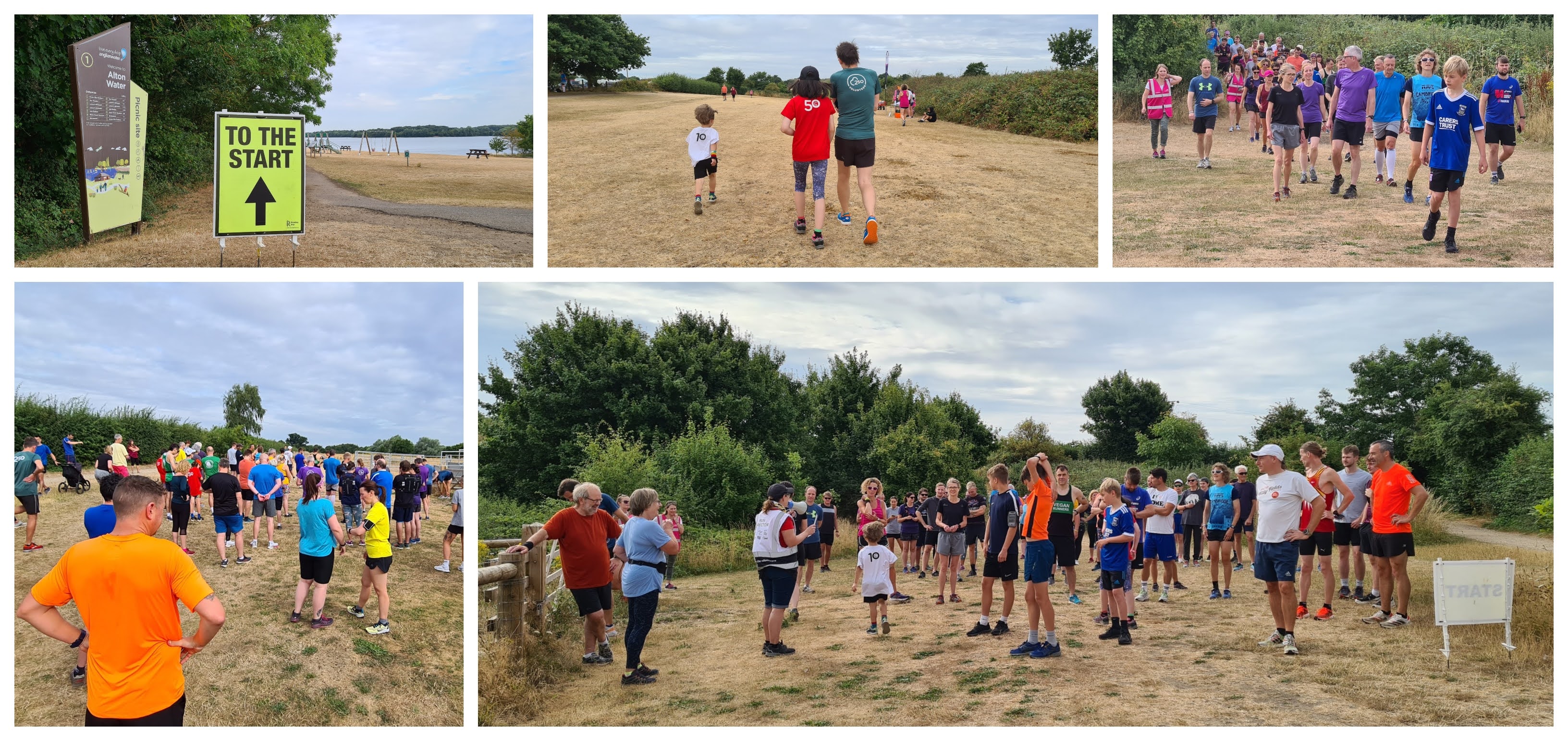
parkrun briefings and start


Wollaton Park has for the last 700 years been home to Red Deer and Fallow Deer. The estate was enclosed at the beginning of the 19th century with a red brick perimeter wall which runs for 7 miles. The grounds have been used for many purposes over the years including music concerts and festivals, and the 1985 and 1989 World Rally Championships were held here. The park and hall have also been used as a filming location on multiple occasions, however the most famous of these was when the hall became Wayne Manor in the 2012 film Batman: The Dark Knight Rises. (check out this video to see all the scenes featuring the mansion). On the subject of Batman, just to the south of Nottingham is a village called Gotham.

We visited Wollaton Hall and Deer Park on Saturday 27 August 2022 to visit the National History Museum for a special exhibition (more about that later) and, as we happened to be there, took part in Wollaton Hall parkrun which has been an active event since February 2020. We had spent two nights staying in the Nottingham Marina Premier Inn and checked-out of the hotel that morning before driving over to the park. The parkrun meeting point and car parking facilities are at the northern end of the park and can be accessed from Wollaton Road. There is a fee of £3 for up to two hours or £5 for the whole day. The preferred payment method is by using the RingGo app, but you can also pay by phone 'or in shops or cafes'. Please note: The car park does not have a traditional payment machine and the earliest you can pay via the app is 8am which is the official opening time.

around the course (first kilometre or so)


If travelling by bicycle, Nottingham seemed to have quite a decent segregated bicycle network and I can report that there were some bicycle racks outside the children's playground, which is next to the car park. I saw an additional set of racks next to another car park which is close to the mansion. If using public transport I gather the two closest train stations are Beeston and the main Nottingham station - both over 3 miles away. There are apparently a couple of bus services that run from the centre of Nottingham to Wollaton Park. Once in the park the toilets can be found next to the playground on the side of the Wollaton 508 Cafe building - this is the official venue for the post-parkrun refreshments and natter. There also appeared to be additional toilets in another building adjacent to the car park.

The parkrun itself takes place over a one lap, gently undulating, lollipop style course but with a zig-zag-style stick. The surface underfoot is mostly tarmac, but also features sections on grass, gravel and trail. I was unsure which shoes to go for and opted for my trail shoes to be on the safe side. I was happy with this decision but I have quite a low threshold for moving to the trail option, so I'm sure many people would be happy in road shoes, especially when the conditions have been dry. There are also a few protruding tree roots to look out for. In the winter I would imagine a larger proportion of people would move to trail shoes. The course seemed perfectly fine for buggy runners.

around the course (second kilometre or so)


The start of the 5km walking/running event is adjacent to the car park and features a long straight opening stretch through an avenue of trees. This slowly climbs where it turns and joins Lime Tree Avenue which curves around past the front of the stunning Elizabethan mansion. The course then passes the adjacent 17th century stables block which is now home to the Nottingham Industrial Museum. The route heads gently downhill into the southern half of the park. Wollaton Park Lake acts as the lollipop of the course. It was created in around 1700 as a feature of the park and was designed to 'capture the atmosphere of the English countryside'.

Once the loop is complete, the rest of the course is just a matter of following the original paths all the way back to the beginning. The main focal point during the event is of course Wollaton Hall and during the event you'll get to see it from multiple viewpoints, all of which are fantastic in their own special way. The park itself is wonderfully scenic and well worth exploring. There is also a golf course nestled into the grounds.

around the course (the lake / halfway / heading back)


I mentioned the deer earlier on in the post, and it's very important to watch out for them and not approach them as they can be unpredictable. Key times of the year to be extra careful are the calving season (June and July) and then rutting season (September and October). Later after the parkrun I saw one of the rangers telling off some members of the public who were approaching the deer (trying to take photos), so just keep your distance. A nice feature of the course is that the final kilometre is 'mostly' downhill. 

With the 5km finished, the barcode scanners are found, as expected, on the grass adjacent to the finish and the post-event refreshment venue is the aforementioned Wollaton 508 Cafe. The cafe building is an old Second World War hut and the name is a reference to the 508th Parachute Infantry Regiment who camped in the park in 1944. During the Second World War the northern part of the park had a large number of these huts installed and they housed German prisoners of war. The cafe had a nice selection of cakes and drinks on offer, and the food options consisted of hot sausage rolls (meat and vegan) as well as pre-made sandwiches and rolls (meat, vegetarian and vegan options were available).

around the course / finish / cafe


The results for event number 60 were processed in the cafe and uploaded shortly after. 283 people had participated and this was slightly higher than the overall average which stands at 254.2 at time of writing. As always I had recorded the course data using my Garmin and you can view it on Strava if you would like to see the course in further detail. The GPS data was also used to create a fly-by video using the very handy Relive app on my phone.

All the locals and volunteers had been really friendly and welcoming to us, so that really made our morning very special. Special thanks to all the volunteers especially the run director who we had been chatting to throughout the morning and managed to get some great pictures of us in what has become one of parkrun's iconic photo spots!

titus: t-rex is king


The parkrun had finished, the results processed, the playground played in, the breakfast eaten, and it was now time for the main reason we were in Nottingham - The 'Titus: T-Rex is King' exhibition which was taking place in Nottingham's National History Museum (in Wollaton Hall itself). The main exhibit was the skeleton of Titus, a T-Rex discovered in Montana's Hell Creek Formation in 2014. It was excavated in 2018 and the exhibition ran from July 2021 until the end of August 2022 (we visited on its final weekend on display).

It was said to be the only T-Rex currently on display in the whole of Europe and also the first time a genuine T-Rex skeleton had been displayed in the UK for over a century. The skeleton was much larger than I had imagined (the photos don't do its size and overall presence justice) and I'm so glad we visited. It was incredible!


Related Links:


Monday, 15 August 2022

Dunstable Downs parkrun

The market town of Dunstable is in Bedfordshire and sits at the western end of the Luton/Dunstable urban area, which also includes the town of Houghton Regis. There are thought to have been settlements around this area as far back as the Bronze Age and was on the route of the Icknield Way, one of the oldest roads in Great Britain (possibly the oldest). In Roman times the area was on the route of Watling Street and a settlement formed here which they called Durocobrivis. It's not quite known where the modern-day name came from, but there are of course a few theories that exist.

To the south of the town lies the chalk escarpment called Dunstable Downs which is at the northern end of The Chiltern Hills. In 1965 The Chilterns were recognised as an Area of Outstanding Natural Beauty. A section of Dunstable Downs has been assigned as a Site of Special Scientific Interest. The downs are home to many types of wildlife including some rare butterflies. The highest point of the downs is 243m and this means it claims the crown of the highest point in Bedfordshire


From a historical point of view, the northern-most section of the Downs is home to Medieval Rabbit Warrens and the Five Knolls Barrow Cemetery which, since 1950, has officially been a Scheduled monument and this status protects it from any unauthorised change.

This area features seven burial mounds which date back around 4,000 years. Late neolithic and Bronze Age burials were the earliest finds, but there were subsequent burials from the Roman era. During the 5th or 6th centuries gallows were erected here and the bodies of around 100 executees, some with their hands still tied behind their backs, were found buried in shallow graves on top of the prehistoric remains.


The area is managed by The National Trust under the full name of Dunstable Downs and Whipsnade Estate. We visited on 13 August 2022 to take part in Dunstable Downs parkrun which has been active since February 2019. The event usually attracts just under a hundred participants each week.

There is a modern visitor building and cafe located at the highest point of the downs and this is adjacent to the car park which has a flat fee of £3.50 and that covers for the entire day. The machines only accept cash and are coin-only, but you can also pay using the 'paybyphone' app. If you need to pay with a banknote or by card, a note on the machine said this is possible by paying at the visitor centre instead. If you are a National Trust member you can park for free (I understand you have to scan the QR code on your National Trust membership card at the machine).


The closest train stations seem to be down in the main Luton/Dunstable urban area and the nearest is over 5 miles away. You may be able to alight at Luton and use a combination of buses to get closer to Dunstable Downs, but from my limited research you may still have over a mile uphill to walk when you alight the second bus.

A train-bicycle combo may work fairly well and upon arrival there are some bicycle racks just outside the visitor centre building. There are toilets on-site and although they have an official opening time of 10am, they should be open before parkrun starts on a Saturday (on the day we visited they were certainly open before 8.30am).


The main parkrun meeting point is on the grass outside the visitor centre, but before worrying about that you will probably want to take in the stunning view to the west where you can see into the neighbouring county of Buckinghamshire. Once the view has been thoroughly absorbed attention can return to the parkrun.

The course here is off-road and the event takes place over what is essentially a single lap course. Underfoot you will find mostly grass, but also some sections of dirt track. We visited during the very dry summer so the ground was firm - even though I could have gotten away with road shoes, I wore my trail shoes and was happy with that choice. In the winter the course will be a different beast and I'd say trail shoes are essential. The briefings, start and finish are all in the same spot outside the visitor centre.


The route initially heads in a northerly direction past the beacon which I understand was lit for the Queen's jubilee celebrations in 2012 and again in 2022. It then loops around the main open grass area outside the cafe and it's not long before you realise that this is not a totally flat course.

This opening loop features a lovely slight downhill, but as we all know, 'what goes down, must come up' and that first incline kicks in at around 400 metres into the course. There is of course that stunning view to take the mind off of such inclines, you may even spot some gliders from the London Gliding Club lined up in one of the fields below. If you are luckier you may spot one or two in the air.


The course now heads south and passes along the edges of fields, through countless gates and even joins the Icknield Way Trail for a couple of short stretches. I remember spotting one section with some heavily protruding tree routes but apart from that the surface underfoot was bumpy but not particularly hazardous. 

As I've mentioned the terrain it might be a good time to cover to deal regarding buggy running - the official advice is to contact the team in advance of visiting if you intend to use a buggy. My thoughts are that it's not really too bad if conditions are good and you are comfortable with undulating off-road buggy running. It may be a different story in the winter, so stick to the advice and contact the team in advance. Also another important point is that dogs are not permitted to take part at this venue.


The course generally rises and falls as the 5k progresses and these undulations are largely on the gentle side. There are plenty of marshals posted at all the important points around the course which is also extremely well marked with signage. In fact the signage and marshals were so good that you'd have to put an extra special effort in to get lost.  The far end of the course features a full loop of a field and at this point the course is only a stone's throw away from the famous Whipsnade Zoo, which at 600 acres is one of the largest in the UK. The zoo opened in 1931 and at the same time work began on a 147-metre-long chalk hill figure of a lion known as the 'Whipsnade White Lion'. It was finished in 1933.

The return journey consists of further grass paths leading around fields until eventually rejoining the Icknield Way Trail path where the outgoing route is retraced back towards the cafe. Up until now I haven't mentioned the rusty brown coloured item sitting on the downs. It looks like a sculpture, but it is in fact a wind catcher which is part of the ventilation system for the visitor centre - an underground pipe takes the fresh air into the building. Talking about wind, I imagine it can get pretty blowy up here at times.


The last 500 metres of the course is generally uphill - it's fairly gentle for most of it, but more noticeable at the very end. With the 5k completed, the barcode scanners can be found just after the finish line and of course the cafe with plenty of indoor and outdoor seating is immediately on-hand for some refreshments (although bear in mind that it doesn't officially open until 10am). The results were online a short while later.

I recorded the course with my Garmin and the GPS data can be found on Strava. I also created an accompanying Relive course fly-by video that can be viewed on YouTube. My lingering thoughts on the course are that it is very peaceful and scenic, but when you add the view into the equation this elevates it to a really special place. As parkrunners we should think ourselves incredibly lucky to be able to indulge our passion in such beautiful surroundings. It was actually a very special day as this was Dunstable Downs parkrun's 100th event which tied in nicely to our visit as my wife also celebrated her 100th run. So afterwards we got to enjoy some of the cakes that had been brought to help with their celebrations.


Once all the cake had been eaten we headed off to take a closer look at the burial mounds and continued to enjoy the stunning view. The freshly harvested hay fields below the downs were looking especially stunning. It also happened to be the hottest parkrunday this year, so we got ourselves back to the cafe for some extra fluids before heading over to Ivinghoe Beacon where there is a view back across to Dunstable Downs and the Whipsnade White Lion can clearly be seen on the hillside. Our final action was to have some refreshing lollies while enjoying the final viewpoint of the day. We'd had a fantastic morning out and would like to extend a heartfelt thanks to all the volunteers that put the event on.

Related links:


Monday, 1 August 2022

Alton Water parkrun

In the county of Suffolk, just to the south of Ipswich is the Shotley Peninsula. It sits between the River Orwell and the River Stour and has a population of around 11,000 people. The peninsula is largely rural and is made up mostly of villages and ancient farmlands. The main crops grown here are wheat, barley, sugar beet and potatoes. The peninsula sits within the Suffolk Coast and Heaths Area of Outstanding Natural Beauty which stretches along almost the entire Suffolk coastline and even into the neighbouring county of Essex.


In the late 1960's it was decided that the nearby town of Ipswich and surrounding areas, including the seaside town of Felixstowe, needed to expand their available supply of water to meet the growing demands of their residents and industries. A feasibility study took place and it was decided that the River Gipping would be able to provide the water and that a reservoir would be required to store it. The Tattingstone Valley within the Shotley Peninsula was chosen as the most suitable location. A dam was constructed between 1974 and 1978, and a 4 mile-long pipeline was used to transfer the water from river to reservoir.

The land now contained within the reservoir was part of the Alton Hall estate and had mostly been used for farming. The centre of the estate, Alton Hall, was unfortunately placed and became lost to the new development. It was a 17th century building which, depending on what you read, was either demolished before the land was flooded or submerged. Another building, Alton Mill, was dismantled and reassembled at the Museum of East Anglian Life, in Stowmarket. It is still standing and can be visited, but the attraction is now called the Food Museum. The Alton Hall name survived when the new reservoir was given the name Alton Water.


The village of Tattingstone was cut in half by the reservoir and the remaining sections are now linked by the 1970's-built concrete Lemons Hill Bridge. Tattingstone also contains a peculiar building known as Tattingstone Wonder. It initially looks like a church, but is in fact a short row of cottages with a flint facade and an imitation church tower added. The story is that the local squire did not like the view from his residence, Tattingstone Place, and had it constructed to improve his view. If you look at the building from the rear you can clearly see that the tower is a folly. In total the flooding of the valley resulted in the village losing around 20 homes.

Alton Water was officially opened on 10 July 1987 by HRH The Princess Royal. Covering 400 acres it is the largest reservoir in Suffolk, the pumping and treatment elements can process up to 10 million gallons of water per day. The southern end of the reservoir contains the main visitor hub and also home to Alton Watersports Centre which offers all sorts of water-based activities. There is also a mini-golf course, a playground, cafe, toilets and cycle hire. On 6 November 2021 the area also became home to its very own free, weekly, timed 5k event called Alton Water parkrun.


We visited on 30 July 2022 and parked in the main visitor car park just next to the village of Stutton. The car park operates on a barrier system which also has ANPR readers to record the number plate. A ticket is collected at the barrier upon entry and payment is made just before exiting. For non-parkrunning visitors this is via the machine next to the toilets, but there is a special arrangement in place for parkrunners where you simply take the ticket into the cafe and let them know that you were here for parkrun. There will be a flat £1 charge and a replacement exit ticket will be given. This one is used to open the barrier upon exit. If arriving by bicycle there is, what I believe to be a cycle rack, outside the cafe.

Travel by other means seems tricky. The closest train stations are Manningtree which is around 5 miles away or Ipswich which is over 7 miles. The onward travel from these places would involve the number 92 bus which runs between both stations, passing Alton Water on the way. Alighting at Manningtree would mean getting the 7.34am bus from the station. Miss it and you've blown it. If alighting at Ipswich, again the number 92 bus is the route that goes past Alton Water, but I don't think it runs early enough to complete the onward journey in time. Obviously, do your own research on this if considering travelling this way just in case I've found incorrect information or if it changes.


Once onsite, the toilets can be found just next to the cafe adjacent to the main car park. They were already open when we arrived at 8.15am. The main meeting point for the parkrun can be found just across the road next to the lake - just follow the 'To The Start' sign. As an added option for arrival at this event, the Alton Water Campsite is right next to the parkrun meeting area so if you have the appropriate camping equipment you could sleep just metres away from the event HQ. The meeting point is actually at the finish line and the start is just a bit further onwards and around a corner.

The course you'll find here is of the off-road variety with underfoot surfaces being a mix of a gravelly path, sometimes with larger loose stones, a little bit of tarmac and the rest on dirt paths and grass. For shoe choice, I decided to go with my regular road shoes, but even though it was bone dry I think trail shoes would have been the better option. Not so much for grip, but I ended up with so much debris inside them that I almost had to stop mid-event to clear them out. Trail shoes seem to do a much better job at keeping this kind of issue at bay. If visiting in the winter or when it's wet, trail shoes would definitely be the way to go. It is two laps and the course profile can be best described as very gently undulating.


The start is a bit further on around a corner and this is where the briefing is held, followed by a quick count down and everyone heads off for a lovely run or walk around this very peaceful area of countryside. The first half of each lap is slightly inland where there are adjacent fields behind a high hedge, this would be fine on a normal day, but we had picked the exact day the farmer had decided to use the combine harvester to harvest some crops. This lead to quite a lot of dust and other debris being blown around in the air. I covered my mouth and nose with my v250 shirt to try to reduce the amount I would breath in, but I moved past it pretty quickly.

The course was very well marked out and the marshals were positioned in all the right places. In fact there is quite a complex network of paths here so good signage is essential, and I'm pleased to say that the team had this element covered down to the finest detail.


About halfway through the lap, the course starts to head back using paths that run, more or less, alongside the reservoir. This gives the second half of the course a slightly different feel and it's worth keeping an eye out for the view across the water where in the distance you can see the clock tower of the Royal Hospital School in nearby Holbrook.

For me the most exciting feature on the course are the Highland Cows which were brought in to help manage the grassland in a sustainable way. There was an information board onsite where I learned that the Highland Cow is one of the oldest registered cattle breeds in the world. They originated in Scotland in about the 6th century and their coats were mostly black rather than the red/ginger they are famous for. The story is that Queen Victoria commented that she preferred the red haired cattle and in an effort to please the Queen, they were then selectively bred this way. On the subject of wildlife, the area is home to some reptiles including the common lizard and grass snake.


There are plenty of uneven surfaces during the lap so it's worth keeping that in mind. It may offer a little more of a challenge for buggy runners, but most would have no trouble getting around. After following the lap around a second time, the finish section breaks off of the loop and the 5k finishes on the open grass area next to the camping ground.

Barcodes and finish tokens are of course scanned right next to the finish line. Once finished I made a special effort to go back onto the course to spend some extra time admiring the Highland Cows, and once that was done, headed over to the cafe where we had some light breakfast. We followed this up with some time in the playground and some ice cream before heading off home at about half-twelve.


I recorded the course using my Garmin and the GPS data can be found on Strava. The data was also used to create a Relive course fly-by video that can be viewed on YouTube.

The results were published very soon after the tail walker had crossed the line and 71 people had taken part in event number 38. This was very close to the official average, so if you visit you can expect an intimate experience with plenty of friendly locals in attendance and volunteering. We were made to feel very welcome, so a huge thanks to all of the volunteers and other locals that spent some time chatting to us.

Related links:


Related Posts Plugin for WordPress, Blogger...