

In the late 1960's it was decided that the nearby town of Ipswich and surrounding areas, including the seaside town of Felixstowe, needed to expand their available supply of water to meet the growing demands of their residents and industries. A feasibility study took place and it was decided that the River Gipping would be able to provide the water and that a reservoir would be required to store it. The Tattingstone Valley within the Shotley Peninsula was chosen as the most suitable location. A dam was constructed between 1974 and 1978, and a 4 mile-long pipeline was used to transfer the water from river to reservoir.
The land now contained within the reservoir was part of the Alton Hall estate and had mostly been used for farming. The centre of the estate, Alton Hall, was unfortunately placed and became lost to the new development. It was a 17th century building which, depending on what you read, was either demolished before the land was flooded or submerged. Another building, Alton Mill, was dismantled and reassembled at the Museum of East Anglian Life, in Stowmarket. It is still standing and can be visited, but the attraction is now called the Food Museum. The Alton Hall name survived when the new reservoir was given the name Alton Water.
The village of Tattingstone was cut in half by the reservoir and the remaining sections are now linked by the 1970's-built concrete Lemons Hill Bridge. Tattingstone also contains a peculiar building known as Tattingstone Wonder. It initially looks like a church, but is in fact a short row of cottages with a flint facade and an imitation church tower added. The story is that the local squire did not like the view from his residence, Tattingstone Place, and had it constructed to improve his view. If you look at the building from the rear you can clearly see that the tower is a folly. In total the flooding of the valley resulted in the village losing around 20 homes.
Alton Water was officially opened on 10 July 1987 by HRH The Princess Royal. Covering 400 acres it is the largest reservoir in Suffolk, the pumping and treatment elements can process up to 10 million gallons of water per day. The southern end of the reservoir contains the main visitor hub and also home to Alton Watersports Centre which offers all sorts of water-based activities. There is also a mini-golf course, a playground, cafe, toilets and cycle hire. On 6 November 2021 the area also became home to its very own free, weekly, timed 5k event called Alton Water parkrun.

We visited on 30 July 2022 and parked in the main visitor car park just next to the village of Stutton. The car park operates on a barrier system which also has ANPR readers to record the number plate. A ticket is collected at the barrier upon entry and payment is made just before exiting. For non-parkrunning visitors this is via the machine next to the toilets, but there is a special arrangement in place for parkrunners where you simply take the ticket into the cafe and let them know that you were here for parkrun. There will be a flat £1 charge and a replacement exit ticket will be given. This one is used to open the barrier upon exit. If arriving by bicycle there is, what I believe to be a cycle rack, outside the cafe.
Travel by other means seems tricky. The closest train stations are Manningtree which is around 5 miles away or Ipswich which is over 7 miles. The onward travel from these places would involve the number 92 bus which runs between both stations, passing Alton Water on the way. Alighting at Manningtree would mean getting the 7.34am bus from the station. Miss it and you've blown it. If alighting at Ipswich, again the number 92 bus is the route that goes past Alton Water, but I don't think it runs early enough to complete the onward journey in time. Obviously, do your own research on this if considering travelling this way just in case I've found incorrect information or if it changes.

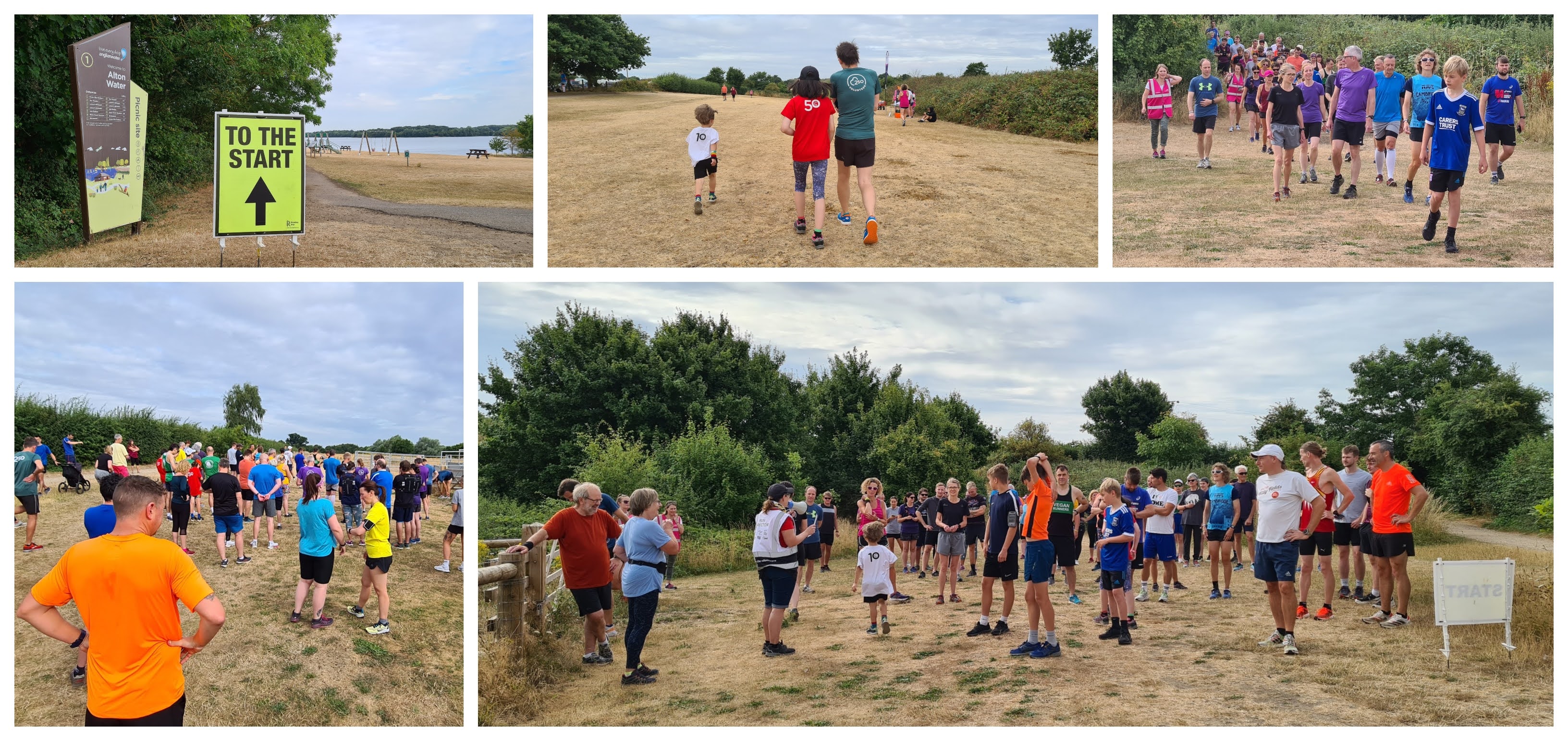
Once onsite, the toilets can be found just next to the cafe adjacent to the main car park. They were already open when we arrived at 8.15am. The main meeting point for the parkrun can be found just across the road next to the lake - just follow the 'To The Start' sign. As an added option for arrival at this event, the Alton Water Campsite is right next to the parkrun meeting area so if you have the appropriate camping equipment you could sleep just metres away from the event HQ. The meeting point is actually at the finish line and the start is just a bit further onwards and around a corner.
The course you'll find here is of the off-road variety with underfoot surfaces being a mix of a gravelly path, sometimes with larger loose stones, a little bit of tarmac and the rest on dirt paths and grass. For shoe choice, I decided to go with my regular road shoes, but even though it was bone dry I think trail shoes would have been the better option. Not so much for grip, but I ended up with so much debris inside them that I almost had to stop mid-event to clear them out. Trail shoes seem to do a much better job at keeping this kind of issue at bay. If visiting in the winter or when it's wet, trail shoes would definitely be the way to go. It is two laps and the course profile can be best described as very gently undulating.

The start is a bit further on around a corner and this is where the briefing is held, followed by a quick count down and everyone heads off for a lovely run or walk around this very peaceful area of countryside. The first half of each lap is slightly inland where there are adjacent fields behind a high hedge, this would be fine on a normal day, but we had picked the exact day the farmer had decided to use the combine harvester to harvest some crops. This lead to quite a lot of dust and other debris being blown around in the air. I covered my mouth and nose with my v250 shirt to try to reduce the amount I would breath in, but I moved past it pretty quickly.
The course was very well marked out and the marshals were positioned in all the right places. In fact there is quite a complex network of paths here so good signage is essential, and I'm pleased to say that the team had this element covered down to the finest detail.

About halfway through the lap, the course starts to head back using paths that run, more or less, alongside the reservoir. This gives the second half of the course a slightly different feel and it's worth keeping an eye out for the view across the water where in the distance you can see the clock tower of the Royal Hospital School in nearby Holbrook.
For me the most exciting feature on the course are the Highland Cows which were brought in to help manage the grassland in a sustainable way. There was an information board onsite where I learned that the Highland Cow is one of the oldest registered cattle breeds in the world. They originated in Scotland in about the 6th century and their coats were mostly black rather than the red/ginger they are famous for. The story is that Queen Victoria commented that she preferred the red haired cattle and in an effort to please the Queen, they were then selectively bred this way. On the subject of wildlife, the area is home to some reptiles including the common lizard and grass snake.

There are plenty of uneven surfaces during the lap so it's worth keeping that in mind. It may offer a little more of a challenge for buggy runners, but most would have no trouble getting around. After following the lap around a second time, the finish section breaks off of the loop and the 5k finishes on the open grass area next to the camping ground.
Barcodes and finish tokens are of course scanned right next to the finish line. Once finished I made a special effort to go back onto the course to spend some extra time admiring the Highland Cows, and once that was done, headed over to the cafe where we had some light breakfast. We followed this up with some time in the playground and some ice cream before heading off home at about half-twelve.

I recorded the course using my Garmin and the GPS data can be found on Strava. The data was also used to create a Relive course fly-by video that can be viewed on YouTube.
The results were published very soon after the tail walker had crossed the line and 71 people had taken part in event number 38. This was very close to the official average, so if you visit you can expect an intimate experience with plenty of friendly locals in attendance and volunteering. We were made to feel very welcome, so a huge thanks to all of the volunteers and other locals that spent some time chatting to us.
Related links:
My GPS data from event 38 (30 July 2022)