Sunday, 20 November 2022

Lordship Recreation Ground parkrun

The area of Tottenham in north London has been occupied by humans for over a thousand years. It is said to be named after a farmer called Tota and was recorded in the Domesday Book as Toteham. Historically, a third of the land in Tottenham was owned by the Bruce family of Scotland. The area remained a rural settlement on the outskirts of London until the arrival of the railway in the late 19th century. This triggered a period of rapid expansion where many homes aimed at the working-class were constructed. Amongst all of this development, a notable area of land remained rural. This was Broadwater Farm, and it remained a working farm until its closure in 1916.

The main reason it had not been developed earlier was that the area was typically waterlogged or flooded due to the land being low-lying and the presence of the River Moselle. In 1932 the land was purchased by the local council where the eastern half was initially used for allotments. The western half was drained and repurposed as a public park called Lordship Recreation Ground. The section of the river that flowed through the former farmland was culverted to reduce the possibility of flooding. The eastern section was marked for future residential development.

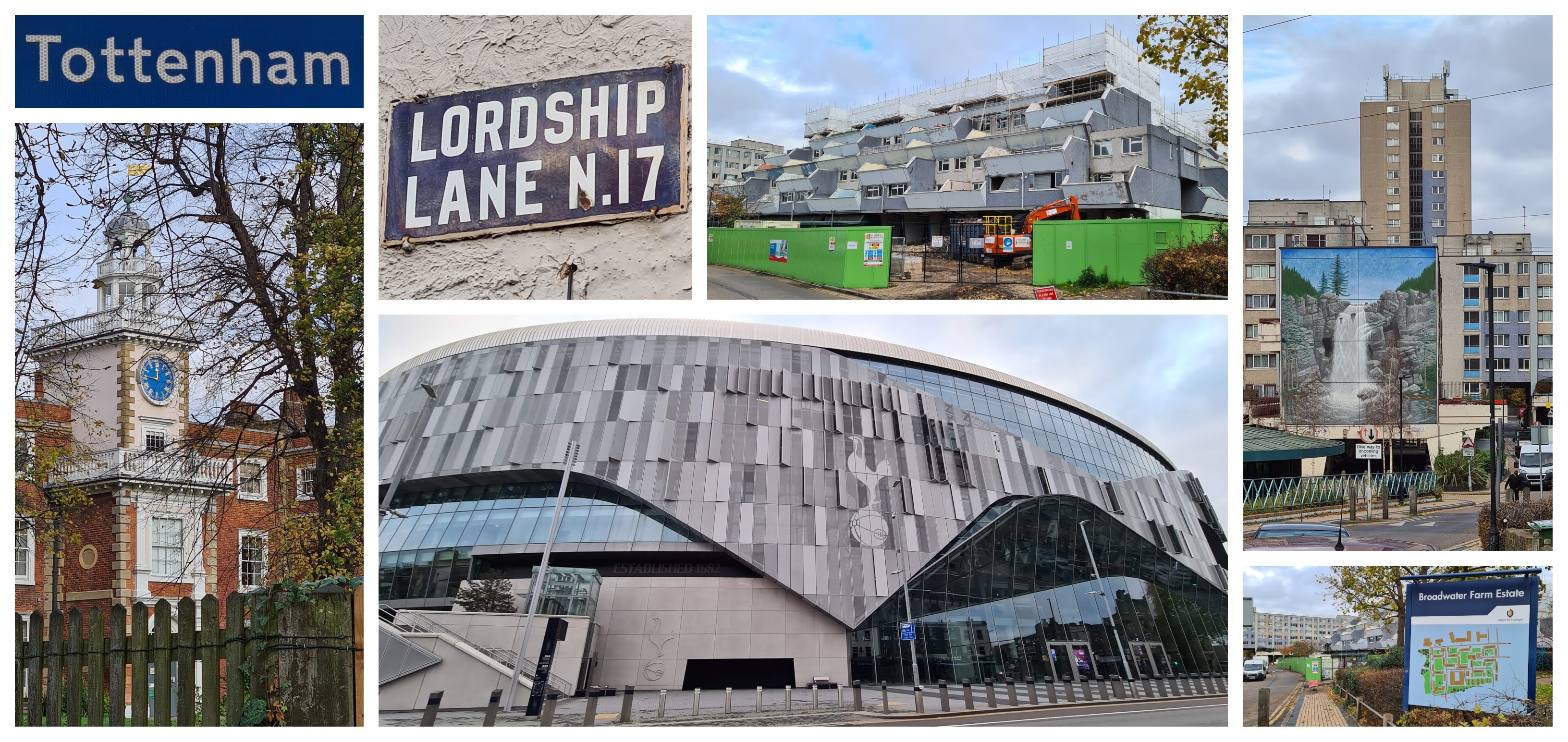
tottenham / bruce castle / broadwater farm estate


Eventually, in 1967, the construction of housing commenced on the eastern half of the former farmland. This was a typical 1960's concrete, dense housing solution. Twelve residential buildings were built and together they formed the Broadwater Farm Estate. To protect homes from the risk of flooding, the ground floor was designated as space for car parking while the residential and retail units started from the first floor. The buildings were interconnected via walkways at first floor level. However not long after its completion, problems began to materialise. The design incorporated many isolated areas and crime grew out of control. I've read that during 1985, the estate recorded 875 burglaries or attempted burglaries, 50 robberies and 50 assaults.

Infamously, also in 1985, the estate was at the centre of the Broadwater Farm Riot which was the culmination of years of racial tension between the largely Afro-Caribbean community and the largely white police force. The tensions finally boiled over when a local Tottenham resident, Cynthia Jarrett, died following a police search of her home. During the riot a police officer, Keith Blakelock was killed. They both have memorial plaques locally, Cynthia Jarrett's is outside Tottenham Town Hall, while Keith Blakelock's is in Muswell Hill. In the following years, a £33 million regeneration scheme was launched, and widespread improvements were made across the estate.

The Lordship Recreation Ground, which sits in the shadow of the estate, continued throughout this time to provide a green space for local residents. However, like many public parks it suffered from years of neglect, but I'm pleased to say that this is no longer the case, and this is largely thanks to the Friends of Lordship Rec. The group have been meeting monthly ever since 2001 and have been instrumental in campaigning for regeneration works to improve the park.

lordship recreation ground


It is around 49 acres in size and opened in 1934. The modern-day park features a children's playground, a paddling pool, football pitches, BMX track, basketball court, an orchard, picnic area, outdoor gym, cafe and toilets. One of its most interesting and longest standing features is the Model Traffic Area, opened in 1938 and is a scaled-down version of a regular road system. It came from a time when the ownership of motor vehicles was still a relatively new concept. It was designed to be a safe environment for children to learn about road traffic and the rules of the road. It was the first of its kind in the UK and maybe even the first in the world. There is some video footage on YouTube from the opening ceremony in 1938.

The park's name comes from Tottenham's Manor House, which is now called Bruce Castle. However, I understand it was originally called Lordship House, and this is also reflected in the name of the road which runs along the park's northern border, Lordship Lane. Bruce Castle is said to be one of England's oldest surviving brick houses and is now a museum. It can be found just to the northeast of Lordship Recreation Ground. Since 1892, the grounds of Bruce Castle have been a public park, which makes it the oldest park in Tottenham.

Heaading back over to Lordship Recreation Ground, which is the largest park in Tottenham. In 2012, the River Moselle (also known as Moselle Brook) was restored to once again flow above ground through the centre of the park via a newly created meandering channel. Three scenic wooden bridges were also installed at this time. There is also a small lake. It is believed the lake is on the same site as an earlier Anglo-Saxon moat. It was once used for boating but has now been given over to wildlife where it provides home to birds, insects and amphibians.

briefings / start


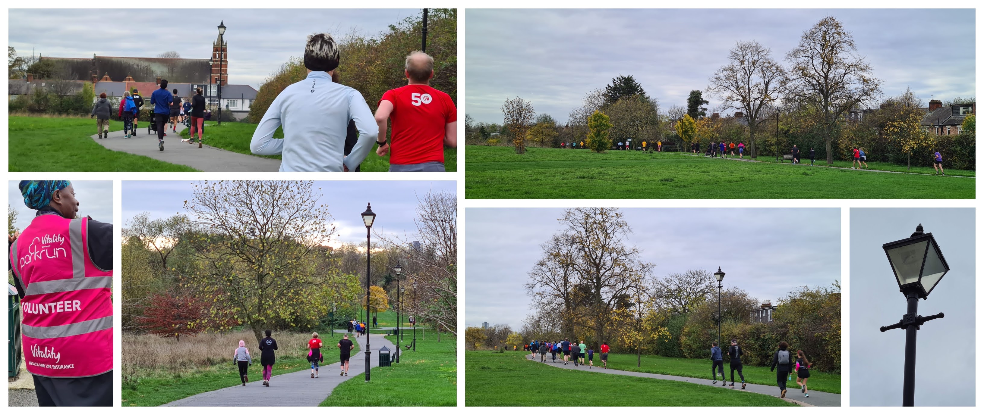
In October 2022 the park became home to Lordship Recreation Ground parkrun, a free, weekly, timed, 5 kilometre event. Despite having the word 'run' in the name, the event is open to everyone and there is actually no need to run it at all. Walking is a perfectly acceptable way to participate. For those that are new to parkrun, you just need to register on the parkrun website where you will be assigned a unique barcode. This one barcode can then be used at any parkrun event worldwide and the result will be linked to your account. A printed copy of this is preferred, but it is now possible to have the barcode scanned directly from your phone screen.

Being a London parkrun, participants are encouraged to avoid using their cars to travel here. In fact the official Lordship Recreation Ground parkrun course page says that there is no car parking within or near the park and that the local roads are covered by Haringey Council's controlled parking zones. While I appreciate the sentiment behind discouraging car use, and not wanting to upset the locals, the information given does not tell the whole story. There are indeed controlled parking zones (CPZ), however, many of the CPZ's in the vicinity of the park only cover Monday to Friday.

It is true that some of the roads nearby do have parking restrictions on Saturdays but the exact timings of the restrictions vary from road to road. However many of the restrictions seem to be designed to be active when Tottenham Hotspur Football Club has a home match. The point here is to make sure you check the on-street signs before parking. When we visited, the roads to the south and the west of the park seemed to offer the best options. Just remember to be respectful and don't do anything that could cause problems between local residents and the parkrun organisers.

around the course / model traffic area


Public transport is of course the preferred method of travel, the closest London Underground station is Turnpike Lane and this is on the Piccadilly Line. It sits just over a kilometre to the west of the park. The London Overground stops at Bruce Grove which is a similar distance away but sits to the east of the park. Seven Sisters station seems to be the closest National Rail station (1.3 miles away), but as it runs along the same line as the London Overground, it'd be fairly easy to change to the Overground and just alight at Bruce Grove, which is much closer to the park. There seems to be a whole range of buses that stop close to the park. The parkrun course page covers the buses quite well, but the options seem to be the 123, 243, 144, 217, 231, 444 and W4.

We visited the park on 19 November 2022 and took part in event number 5. We entered via the gate off of Higham Road which is at the highest point of the park. If you stand in the right place, you can see Alexandra Palace in the distance (home to Ally Pally parkrun). The meeting point for the parkrun is in the centre of the park next to the Lordship Hub community centre, and this is also where the toilets can be found. There are two sets of cycle racks in the park; the first at the Lordship Hub and another set near the multi-use games area over on the eastern side. The 5 kilometres are covered over a three-and-a-bit lap course which uses the main tarmac paths around the park. The course is basically flat with just the slightest change in elevation of a couple of metres each lap, which makes it suitable for everybody including wheelchair users and for those pushing buggies.

The park is big enough to accommodate a two-lap course, but that would have involved a couple of trips up a hill. I learned from an interview on episode 227 of the With Me Now podcast that the decision to stick to the flat areas was an intentional design feature in order to make the event accessible to all. The event has two briefings. One is for first-timers, and took place outside the Lordship Hub. This was followed by the main briefing for everyone over at the start line. The start of the event is on the path that runs east-to-west across the centre of the park.

around the course / shell theatre / north side


The participants follow this path heading westwards and at the end turn left to join the main quadrilateral-shaped main loop which makes up the majority of the 5km. The route is really easy to follow, but there were also plenty of direction signs and marshals dotted around the course. The first significant feature that is encountered is the Model Traffic Area (the course goes through this area four times). It's such a brilliant feature of the park and is super cool to run through - just watch out for the low hanging branch on one of the trees. Also look out for the Shell Theatre with its bold eye-catching colour scheme - it has been a feature in the park for many years and has been used for all sorts of performances from tea dances in the 1940's to folk and jazz festivals in more recent times.

The lap continues right up to the northern end of the park where it passes the Lordship Lane entrance and this leads into the last part of the lap which heads along the western side of the park - this western side of the park really stood out for me, as I really enjoyed the meandering path which is lined with historic lamp posts. Once the three-and-a-bit laps are complete, the course turns onto the original east-west path from the eastern end where you pass back through the original start point and carry on a bit further until reaching the finish area.

north and west sides


The parkrun volunteers take care of barcode scanning right after the finish line and the Lordship Hub Cafe is the place to go for post-parkrun refreshments. The hub has a fairly limited range of food options but you can get the usual selection of drinks. It's run by volunteers, and this gives you a sense of how the local community really gets involved in all aspects of this park.

The hub also hosts all sorts of community events and sessions every day of the week. You'll find things like weekly older people's coffee mornings, yoga, pilates and capoeira classes, watercolour painting group, and a 'Lunch Hub and Pantry' where people on low incomes can get a free hot meal and also have access to a food bank. There's also a Hub Repair Cafe where clothes, toys and gadgets can be brought in and experienced fixers will assist in repairing them. Plus on the first Saturday of each month you can find The Trove Market which has lots of free activities as well as goods for sale on the stalls.

finish


The community spirit is clearly very strong here, and this was also seen over at the Model Traffic Area, where we joined in with a children's bike training session run by the Wheely Tots charity. The kids were allowed to borrow bikes and spent a good hour riding around the mini roads.

I was hoping to find some locally made Tottenham Cake while we were here, but I couldn't find anywhere that sold any in the vicinity of the park. Tottenham Cake is a tray-baked sponge with a pink icing on top. It was created by a local baker named Henry Chalkley and the pink colouring for the icing came from the Mulberries that grew in the grounds of the Quaker House on Tottenham High Road.

I recorded the parkrun course using my Garmin, and the GPS data can be viewed on my Strava account. That data was also used to create a Relive course fly-by video, and that can be viewed on YouTube. The results for event 5 were online shortly after the event. At the time of writing it is difficult to know exactly how many participants this event will attract on a regular basis, but on this particular week there were 229 finishers. The numbers are still a little inflated as there are still a large number of tourists visiting, so it'll settle down soon enough.

post parkrun: the hub / model traffic area


This is one of those places where the history of its past events had made me feel a little nervous about attending, but what we found when we arrived was the most amazing community of people doing things purely to make their neighbourhood a better place to live in. Not all places we visit are like this, and we were only there for a very short period of time, but we could definitely feel it in the air. It's so, so humbling to see this in action. This was captured on film when BBC Countryfile did a piece on Lordship Rec, it's available on YouTube and definitely worth watching.

The parkrun, of course, perfectly encapsulates the same values, and I'm sure it'll be such an important part of the future of the park and the community that uses it. Thank you so much to all of the volunteers for putting the event on and for the very warm welcome when we visited.


Related Links:

The course GPS data (November 2022)
The course fly-by video (November 2022)


Sunday, 13 November 2022

Dartford parkrun

Dartford is a town in Kent with a population of around 115,000 people. The area is thought to have been inhabited since pre-historic times, at least 250,000 years ago. The beginnings of the town we know today came from around 2,000 years ago when the Romans built the main road from Dover to London. The road had to cross the River Darent via a ford resulting in the town initially being known as Darentford (recorded in the Domesday book as Tarentford). The name Darent is thought to mean 'clear water'. The first substantial settlement is thought to have been set up in Saxon times. In the 14th century Dartford Priory was established and this remained until King Henry VIII's Dissolution of the Monasteries saw the Priory closed down c.1539 and the estate was transferred to the Crown.

Henry VIII upgraded the Manor House (using some of the stone from Barking Abbey) and by 1545 had added a Gatehouse. It is known that Henry held meetings of his Privy Council here and for 5 days in 1545 Dartford was the seat of the national government. King Henry's fourth wife and Queen of England, Anne of Cleves was given the Manor House as part of her divorce settlement and resided here for a number of years before her death in 1557. The Gatehouse and part of the original priory wall survive to this day. The Gatehouse can be found on Priory Road along with part of the wall which also runs along Victoria Road.

around the town: gatehouse / library / station / church tower


Dartford has many other links to royalty and other historic events. Henry III's sister, Isabella, was married by proxy here in 1235 to the German emperor Frederick II. Wat Tyler is said to have assembled in Dartford with his rebels during the Peasants Revolt before marching towards London. In 1415 Henry V is said to have attended a thanksgiving with 700 soldiers in Dartford's Holy Trinity Church after victory at the Battle of Agincourt during the Hundred Years War. Just a few years later, in 1422, his body rested here while being taken from France to Westminster for his funeral. It is known that the Duke of York camped on an elevated area known as The Brent with his army (allegedly 10,000 men) during the War of the Roses, in preparation for a battle with Henry VI who had assembled at Blackheath. The duke eventually reached a settlement with the King (or surrendered) and no battle took place.

The good water quality of the river led to many water-based industries such as brewing, fulling and fabric printing becoming based in the town. In 1588 Dartford was the site of England's first paper mill and England's first Iron-slitting mill was opened here in 1590. The site of the paper mill was subsequently used in the manufacture of gunpowder. Mining engineer and inventor, Richard Trevithick, designer of the first working railway steam locomotive, lived in Dartford for the final year of his life. He had been working at the Messrs J&E Hall manufactoring company which occupied the site of the Priory. He died here penniless in 1833 and is buried in St Edmund's Pleasance burial ground which is at the top of East Hill. However, as many grave stones were removed the exact position of his body is unknown. A commemorative plaque can be found within the grounds. It is also a great spot to look at the view over the town.

around the town: library and flowers / bridge / the wat tyler / mick jagger / war memorial


The Buroughs Wellcome chemical works, founded by Sir Henry Wellcome, had a large presence in the town. Through a series of mergers it eventually became part of the GlaxoSmithKline pharmaceutical company which continued the link with Dartford, however in 2008 GSK announced that they would be leaving the town - this has now happened and the land redeveloped into housing. Dartford was home to the Littlebrook power station which featured one of the tallest chimneys in the country. The power station closed down for good in 2015 and the chimney was demolished in 2019. We used to be able to see it from our front room window, and I had a soft spot for it. I remember watching it come down early one Sunday morning. The site is now home to an Amazon warehouse. Another interesting and quite random fact is that Dartford is home to a grape vine, planted next to the river not far from the train station, in 1979. In 1990 the vine set a new world record for heaviest grape crop, weighing in at 5,071 pounds. The vine is known as the wonder vine.

The famous pop artist Peter Blake was born in Dartford, he designed a number of album covers for musical artists such as The Who, Paul Weller and Oasis, but most notable is his work on co-creating the cover for The Beatles album Sgt. Peppers Lonely Hearts Club Band. While on the subject of music, the town was the birthplace of Mick Jagger and Keith Richards (check out the new statues on the High Street). They attended the same primary school together, but then lost touch. They famously met again on platform two of Dartford Railway Station in 1961 and of course went to be part of one of the most famous rock and roll bands of all time. They are one of many famous bands who used Vox amps which were manufactured in Dartford by Jennings Musical Industries. The town centre is also home to the Goodman Dance Academy which was set up in the 1970s by Strictly Come Dancing judge, Len Goodman.

central park


The modern-day Dartford is largely a commuter town for workers in London, but the most famous landmark is probably the Dartford Crossing where the Queen Elizabeth II Bridge dominates the sky line. The main shopping area in the town centre suffered greatly upon the opening of the nearby Bluewater Shopping Centre, but recent developments have lead to the appearance being improved in recent years. To the south of the High Street is Dartford's main public green space, Dartford Central Park. A small section of land had been donated to the town and the initial park opened in 1905. Over the years features have come and gone, and the most-recent expansion was the purchase of land formerly owned by GlaxoSmithKline, which brought the total size of the park up to 26 acres.

It features very well kept flower gardens (45,000 plants are planted each year to create these) as well as a circular flower-bed where an intricate design can be found. This changes every year or so and tends to feature designs that mark significant occasions such as the Queen's Platinum Jubilee, which is the design at time of writing. There is a children's playground (completely redesigned with a pirate theme in 2023), cafe, bandstand, skate park and open sports pitches, plus the River Darent discreetly flows through the centre. At the far south of the park is a sports track which is home to Dartford Harriers and Central Park Athletics. The track, which now has a distinctive blue surface, is notable as the location of Zola Budd's first race on British soil which attracted a large crowd and was broadcast live on BBC's Grandstand. She won the race and set the venue's female 3,000m track record, and I believe it still stands today. 

dartford parkrun start and opening section


The athletics track clubhouse is the base for the park's free, weekly, timed 5k event called Dartford parkrun. I have a strong personal link to this venue, not only is it my home parkrun, I was involved in its creation and part of the core team during the first few years of operation. Meeting my friends at 7.30am on a Saturday to set the course up week after week, even through the winters, remain as some of my best parkrun memories. I gradually stepped back from being in the core team and now tend to help out every now and then as the tail walker, which I really enjoy doing.

For anybody visiting, Dartford is of course not far from the M25 so is quite simple to get to. The athletics track has a car park and this can be used by parkrun attendees for the duration of the event. If parking there it is worth noting that on some weeks the car park is only available until a certain time, usually 11am. If cycling there are cycle racks at the main entrance of the park near the town centre and outside the park's cafe, but most cyclists tend to use the fence around the athletics track area to secure their bike. Many local buses pass through the town and the main hub of bus stops is located next to the train station (the buses also used to stop outside the park, but the redeveloped town centre means they no longer take this route).

bridges and off-road section


Dartford has good train links and the station is a significant hub which has three different lines running in and out of London, as well as a line which goes off deeper into north Kent. The station is about 1km from the parkrun meeting area, but after about 500 metres the route enters the park itself. You just have to walk across to the far side. As far as toilets are concerned, the general public toilets within the park are located less then a minute from the athletics track, however there are toilets within the track's clubhouse that parkrunners are free to use. Bags and belongings can also be left in here.

The parkrun itself starts right outside the track entrance with the start line conveniently placed in-between two trees. First-timers and the main briefings take place on the grass here before the event gets underway. The original course was two laps but that was changed to assist in spreading attendees out and to avoid lapping occurring at a particular pinch point. The current course has been in use for the majority of the event's existence. You may hear people refer to the course as a two-and-a-half lapper, but I prefer to describe it as a three lap course. The first lap is a small loop around the main open grass area and this brings everyone back around to the start line about 700 metres later. The remaining two full laps are then commenced with the field nicely spread out.

the football fields and back into the main park


While following the initial same path as the opening lap, the full lap takes a turn over the River Darent via the park's twin bridges. The course then enters an area which most locals have never ventured into. It's a grassy trail path which follows the river and at the end swings in a short uphill section through a wooded area. There are some significant tree routes here so care must be taken, and during periods of heavier rain you may even spot the flow of water running down the path. At the top of this path the route follows the edge of the grass sports fields until reaching the path where the course heads downhill and back across the bridges. A not-that-well-known fact is that underneath the football pitches lies the remains of a Roman Villa. It was first discovered in 1895 and re-excavated in 1979.

Back in the main section of the park the course rejoins the original small loop for a short section before heading round towards the formal flower beds. This area of the park is also home to one of the arches from the town's old medieval bridge which was reconstructed in its present location in 1923. A stream used to flow under it but it is now underground. From here the lap works its way back towards the start/finish area following the path around the bandstand which is officially called the Sir Henry Wellcome Bandstand. It dates from 2010 so is quite a new addition to the park. On Sundays during the summer there are usually a series of free concerts performed by various local brass bands. The route again rejoins the original smaller loop and this now leads round to the start area, which at the end of the final lap is now the finish.

cafe / bandstand / northern section of park


As the course is mixed terrain I find trail shoes better during the winter, especially during the uphill trail section which can be quite slippery when it is wet, however there is still a fair amount of tarmac so some may prefer to stick with road shoes. The course is generally fine for buggy runners, but again it's the uphill trail section which can be problematic - the tree roots in a couple of spots are significantly raised creating quite a lumpy path. Given this section I would say that it is not the best course to attempt if using a wheelchair. Another thing to note is that the parkrun usually suffers from three pre-planned cancellations throughout the year; The Trevithick Steam Fair (May), The Dartford Festival / Dartford's Big Day Out (July) (since Covid these two have been combined into one July event) and then again for the Dartford Fireworks Display (November).

The barcode scanning takes place on the grass next to the finish line and some light refreshments, sweets and crisps can be purchased from the Central Park Athletics clubhouse. For a more significant breakfast the best place would probably be The Flying Boat Wetherspoons near the High Street, but the park also has its own cafe next to the playground.

medieval bridge / end of lap/finish


The results are processed in the clubhouse so would usually be published quite soon after the tailwalker crosses the finish line. The usual attendance figures hover around the 150-200 mark. The GPS data of the course can be found on my Strava account and if you'd like to see a Relive fly-by video I have one on YouTube. I should also note that I have used a selection of photos taken between 2014 and 2022, but the majority were taken in 2022. Most were taken by me but there are others where I cannot find the name of the photographer in order to add a credit.

Related links:


Saturday, 5 November 2022

Gunpowder parkrun

Waltham Abbey lies at the western end of Essex, just near the borders with Hertfordshire and London. The town's recorded history dates back to the 11th century. It was originally the ancient parish of Waltham Holy Cross where it took its name from its former abbey. The abbey itself is notable for being the last to be dissolved following King Henry VIII's Dissolution of Monasteries. In fact, King Henry VIII is known to have been a frequent visitor to the town and stayed on multiple occasions. The abbey is one of a number of possible burial places of King Harold II, who was the last Anglo-Saxon King of England.

waltham abbey


One of the early industries at Waltham Abbey was fulling, used for cloth production. This was possible due to the supply of water from the Millhead Stream which is a man-made water course supplied by water from the River Lea. The mills also went on to produce vegetable oils. During the 17th century, shortages in gunpowder required for the Second Dutch War resulted in the mills turning their attention to producing gunpowder. The mills were privately owned until, in 1787, they were purchased by The Crown, thus ensuring the security and high quality of this highly valuable commodity. It was known as The Waltham Abbey Royal Gunpowder Mills and was one of three such sites in the UK.

Over the years, demand for gunpowder for military use grew during periods of conflict, such as Napoleonic Wars (which included The Battle of Waterloo), the Crimean War and the Boer War. Large quantities of gunpowder would have been taken south to the Royal Arsenal in Woolwich (now home to Thames Path parkrun, Woolwich) via canal. Demand was traditionally lower during times of peace but during the industrial revolution demand for gunpowder from commercial companies such as those in the mining, construction and tunnel building industries kept the mills busy. Then of course, World War I started, and production soared to a new high where the Royal Gunpowder Mills' employees doubled from 3,000 to over 6,000 people. It was notable that most of the additional workers were women, and this marked quite a significant point in social history.

gunpowder park


The mills, associated buildings and munitions testing grounds were spread across two adjacent sites, typically known as the North site and the South site. Advances in technology meant that newer explosive technologies became favoured. The mills were involved in producing TNT and also RDX - two of the components which make up Torpex, and this was the explosive used in the famous Bouncing Bomb (Dambusters) during the Second World War. In 1945 The Waltham Abbey Royal Gunpowder Mills closed. Almost immediately the site re-opened as The Explosives Research and Development Establishment, and in 1977 it became the Propellants, Explosives and Rocket Motor Establishment where they worked on the Skylark project who produced research rockets.

By 1991 both sites had closed. The North site is now largely covered by Waltham Abbey Site of Special Scientific Interest, and it also still contains many of The Royal Gunpowder Mills buildings. It is run as a heritage centre where visitors can learn all about the fascinating history of this very significant place. The South site was decontaminated and sold for development. It is now a combination of supermarket distribution centre, housing, and the remaining 255 acres are called Gunpowder Park. It is part of the Lea Valley Regional Park, and its main focal points are wildlife, science and the arts. At 9am on Saturday mornings it plays host to a 5km event called Gunpowder parkrun.

parkrun briefing / start


I previously visited Gunpowder parkrun back in December 2012, and on that occasion, I travelled from central London using a combination of the London Underground followed by a Greater Anglia train where I alighted at Enfield Lock (there is of course a Waltham Abbey station, but this is further away from the park). From Enfield Lock it is possible to walk in an easterly direction and enter the park via a small footbridge that crosses the River Lea - at this location, the river forms the border between London and Essex. The parkrun meeting point is over on the east side of the park, so it's about a 2km walk in total. Cycle racks are available and they are located in the main car park.

If travelling by car, the main and obvious place to park is the main Gunpowder Park visitor's car park. This on the east side of the park and is accessed from Sewardstone Road (the A112). The car park has a fee which rises depending on the duration of your stay. As things stand (November 2022), payment needs to be made just before you exit and the machine will calculate the cost based on the time the ANPR camera recorded your entry. The on-site payment machine is debit/credit card only (no cash). The signage in the car park also suggests that payment can be made by telephone or by registering with the 'good2go' website. Please also note that, according to my quick count, the car park only has 45 regular spaces, plus a further 5 disabled parking spaces. If the car park fills up, the noted alternatives are all in the town centre. You can complete the rest of the journey (1-2km depending on where in the town centre you park) on foot or by taking the 505 bus which stops close to the main entrance on Sewardstone Road. There may also be some on-street parking available locally, but if you do go for this please be respectful of local residents.

around the course


The parkrun meeting point is on the eastern side of the park just near the main entrance, car park and the toilets - I'm not sure of the official opening time of the toilets, but they were definitely open at 8.30am on the day we visited. A first-timers briefing takes place and this is followed by a full briefing. The whole crowd is then led around to the start. At 9am the participants are sent on their way around the park. The course here at Gunpowder parkrun is two-and-a-bit laps which on this visit was on a clockwise course. However from 14 June 2025 the course is negotiated anti-clockwise with a different starting point. Underfoot is a compact gravel surface, so road shoes are fine on this course, it is also fine for buggy runners. Overall it's reasonably flat but there are a couple of gentle inclines during the first half of each lap.

The park is divided into four bioregions. Firstly, there's the Cob Fields (The Shock Wave Galleries) - This zone consists of bands of trees and shrubs which have been designed to represent the shock waves sent out during an explosion, with the blast centre located fairly close to the parkrun meeting area. The second zone is Cob Meadow (Blast Mound Plateau) which provides ideal nesting grounds for Skylarks. The third is Osier Marsh (The Salix) which is an area of wet woodland which provides a great environment for wildlife to thrive. As I understand it, Osier is the name of a certain type of Willow, which grows in abundance in this area and is part of the Salix genus. Lastly there is the Cob Fields (The Energy Fields) this area features some arable farmland and contains a viewpoint at the top of an incline.

around the course


At this venue the course is not marshalled (this was noted in the briefing), but instead relies on direction arrows to help parkrunners navigate the course. Fortunately, it's quite an easy route to follow. Being a clockwise course, it features mostly right-hand turns, but there's also a single left turn as well (note that from 14 June 2025 the anti-clockwise course is mostly left-hand turns). A fact that I find quite interesting about Waltham Abbey is that the Meridian Line passes right through the centre of the town, and it also goes straight through Gunpowder Park, meaning this is currently the UK's only 5k parkrun whose course actively crosses the line (the participants cross it four, or possibly five, times). There's a bit more info in my Meridian Line parkruns post.

Once the two-and-a-bit laps have been completed, there's a finish funnel set up on an offshoot of the main path. Barcode scanning takes place at a table over at the main meeting point, There isn't an on-site cafe for the post-parkrun social, but I understand they have a community cafe once a month (possibly the second Saturday). I recorded the course with my Garmin and uploaded the data to Strava where I spotted a few witty gunpowder-themed segment names. I used that data to create a course fly-by video using the Relive app on my phone. I was actually quite relieved that the GPS worked as when I visited in 2012 all of my GPX files ended up being corrupt. Please remember that the course changed on 14 June 2025.

around the course


In terms of expected numbers of participants, as of 2022, Gunpowder parkrun generally has around 150 taking part each week. However, we visited on 5 November 2022 which of course tied in perfectly with Guy Fawkes Night and the Gunpowder plot of 1605. On this particular day 479 people participated in the parkrun which broke their previous attendance record by a whopping 150. It was of course a huge undertaking for the team of volunteers who had to cope with three times as many participants as they would usually expect.

With such a high number of finishers, towards the end the finish tokens ran out, so the last 29 people (us included) received their finishing position either in writing on their hand or as a hand written number on a piece of paper. It didn't help that it was raining, which then caused problems with scanning and writing down barcodes! I'm sure there was a little stress behind the smiles, but they coped magnificently and I can only offer my sincere thanks to each and every one of the volunteer team for making sure everything went as smoothly as possible. I think they'll be relieved that the next time 5 November falls on a Saturday is in 2033!

the finish / barcode scanning


You may notice our green cuddly toy in some of my photos. This is a Creeper, and it is found in the Minecraft video game. Its significance at this venue is that, firstly, the way the Creeper attacks the player is by silently creeping up and then exploding. Also, if you manage to kill a Creeper, the item it drops is gunpowder. So, if anyone was to pursue a Minecraft parkrun challenge, this venue would be on that list!


Related links:


Related Posts Plugin for WordPress, Blogger...