Sunday, 19 March 2023

Brockwell parkrun

Please note that a new route is due to be in use from 21 December 2024 - I will post further information shortly.

- - -

The London Borough of Lambeth occupies an area of 10.36 square miles just to the south of the River Thames. It has a population of just over 300,000 people. In the 12th century, the area was in the Manor of Lambeth, which was owned by the Arch Bishop of Canterbury. Lambeth Palace, is still the Arch Bishop's official London residence whose library contains the largest collection of religious books outside of the Vatican. There are two districts within the borough that are important to this blog post, these are Herne Hill and Tulse Hill.


The area which is now home to Brockwell Park was formerly part of the large area belonging to the Tulse family, their name is of course immortalised in the district of Tulse Hill. However, the association with the family has a darker side as they were heavily involved in the West African slave trade. The area has a link to astrophysics, as astronomer Sir William Huggins lived and worked in his private observatory (at 90 Tulse Hill Road) where he did pioneering work in the area of astrophysics. He was the first person to distinguish the differences between nebulas and galaxies.

In the early 1800's the parkland was acquired by a glass merchant named John Blades. He had a mansion built at the highest point of the park and this was named Brockwell Hall, replacing an earlier building of the same name (also previously referred to as Brockalle and Brockholds), but in a slightly different location. The grounds, which had been fields, were now laid out as a private park. When the estate was put up for sale in the 1880's a local MP, Thomas Lynn Bristowe, led a campaign for it to be purchased for the benefit of the public, which it was.


The site was opened as a public park on 6 June 1892. Tragically Thomas Lynn Bristowe died from a heart attack on the steps of Brockwell Hall during the opening ceremony. The park was subsequently expanded and landscape architect Lt. Col. JJ Sexby was hired to create many of the park's features. He added formal flower beds, ponds, trees, paths, a bandstand and an 'Old English' walled garden. In celebration of Queen Victoria's Diamond Jubilee (1897), Sir Charles Ernest Tritton MP, Bristowe's successor, donated a clocktower to the park. It is known as Brockwell Park Clock Tower, or sometimes the Tritton Clock. It still stands in the park, and was fully restored in 2014.

In 1937 the Brockwell Lido was opened. Its design is of the Moderne Style (apparently closely related to Art Deco, but not quite the same). The lido had a brief period of closure in the 1990s but is now fully open. It was given Grade II listed status in 2003. The Second World War saw the park transformed. Parts were used as an army training ground, air raid shelters were installed, some of the ground was used for allotments, and buildings were constructed where research into vaccines was carried out. Once the war ended, it returned to being a public park and since in 1970 it has been under the care of Lambeth Council.


The 1980's saw Lambeth Council put forward plans to create a 1,000-seat athletics stadium in the park. This led to the formation of the Friends of Brockwell Park, who successfully campaigned against its creation. They have been a voice for the local residents ever since.

The modern-day park covers an area of 126 acres and has been given Grade II status on the Register of Historic Parks and Gardens. It sits within the boundaries of the Herne Hill district. Most of the original features mentioned above still exist, however the bandstand was demolished during the second world war. The park also now has a playground, tennis and basketball courts, BMX track (home to Brixton BMX Club) and a 7 1/4 inch miniature railway. The park also hosts the Lambeth Country Show every summer. Over the years it has also hosted a number of festivals, with many well-known musical artists such as Elvis Costello, Aswad, Pete Townshend, Stiff Little Fingers, The Style Council, Madness, The Damned, The Manic Street Preachers, The Levellers, Four Tet, Erikah Badu, Grace Jones, Yoko Ono and Boy George, all performing here over the years.


In December 2010 the park became home to a free, weekly, timed, 5km event called Brockwell parkrun. We first visited in 2013 where I took part with my daughter in the running buggy. We did actually visit the park again in 2014, but for Brockwell junior parkrun where my daughter ran and I volunteered as the official photographer. After re-reading my original 2013 Brockwell parkrun write-up, I realised it needed to be re-written, so in order to give it the full treatment, we revisited the park on Saturday 18 March 2023 and took part in Brockwell parkrun's 537th event.

Being in London, public transport options are generally pretty good. There are a number of buses that pass close to the park, the numbers 3, 37, 196 and 690 all stop right outside the Lido, while a whole host of other services stop on Norwood Road, to the south of the park. As far as trains are concerned, Herne Hill is the station to head for. There isn't an overground or underground service directly to the park, however, the closest option for the underground would be Brixton via the Victoria Line. That would leave around 1 mile to complete the rest of the journey. For any cyclists, there is a large bank of cycle racks right outside the lido.


If driving, the obvious place to park is outside the lido on Dulwich Road which allows free on-street parking at weekends. If that doesn't work out, the side roads off Dulwich Road appear to have the same arrangement. Once in the park, the parkrun meeting point can be found in the area adjacent to the lido. However if you need to use the facilities, you'll need to take a short walk over to one of the two public toilet blocks in the park. The closest is next to the BMX track (500 metres walk from the lido), while the other option is next to the walled garden (about 700 metres walk from the lido). Just before 9am, the briefings take place within the gravelly area adjacent to the footpath.

The course is two anti-clockwise laps of the park, but the laps are not identical. The surface underfoot is tarmac so road shoes are the go-to option at all times. If you were reading carefully beforehand, you may have already figured out that the park isn't flat. The park is fine for a spot of buggy running. I'd imagine that surface-wise wheelchair athletes would be fine, you'd just need good strength in your arms for the inclines. Attendance figures seem to hover around the 300 mark, so it's well attended and you should find a diverse range of abilities from super-fast all the way through to the walkers.


The start can be found on the path just to the north-west of the lido. The first lap is the longer of the two and the first section is not repeated on the second lap. It is asked that parkrunners keep to the left hand side of the paths where possible. It starts by first heading to the north where there's a sharp but wide and smooth turn where the course follows the perimeter path. The first kilometre consists of a long, slow incline all the way to one of the park's high points at the south-west corner of the park. Along here there's a glimpse of the ponds and it is also possible to see Crystal Palace Tower (Crystal Palace parkrun write-up) in the distance.

Once at the highest point of the course (reached at 1.1km and 3.5km), the participants have earned the right to a bit of downhill, and that's what happens all the way from the south-west corner along the south and eastern sides where you can get a glimpse of Brockwell Hall. The undulating nature of the park really helps to make it very scenic and picturesque. When approaching the park's Herne Hill entrance, the scenic parkland is briefly overshadowed by the hustle and bustle of the busy road junction at Herne Hill station just outside the park, but the peaceful park scene is restored quite quickly after passing the gate.


Towards the end of the loop the course passes the miniature train line, followed by the lido, and the next section of path leads towards the original start point. However the course doesn't go all the way back to the start. On the first lap, the course takes a left-hand turn and heads uphill past the gravelly briefing area and the BMX track. This mini-summit is soon reached and the course immediately heads downhill where the path rejoins the perimeter path near the ponds. The course now continues on the familiar sections of perimeter path right the way around past the lido where the finish funnel can be found.

There were marshals dotted around the course in many useful places, but I will note that there were some sections where the paths split with no marshals or signs to guide the way. Most participants will be fortunate enough to just follow the crowd, but if someone happened to be in a place within the field where there is no-one to follow, it would be possible for a wrong turn to be made. Anyway, once through the finish funnel, the participants head back into the open gravelly area to have their barcode and finish token scanned.


The official post-parkrun social venue listed on the course page is the Brockwell Park Cafe located in Brockwell Hall, which is over in the centre of the park right on top of the hill. There is another on-site option, which is the Four Hundred Rabbits cafe/restaurant which is located within the lido building, and I suspect that if any parkrunners stayed for refreshments may have gone there as it is closer to the finish. We had already decided to explore the park, so we wandered up to the Brockwell Hall Cafe for our breakfast and they had a brilliant selection of food, drinks and cakes. Inside the main doorway is a bust of Thomas Lynn Bristowe, so it was nice to see that he is remembered, as it is possible that the park would not be here if not for his efforts.

I really have to say that this park must be one of London's finest. Our post-parkrun explorations led us into the walled garden, which was brilliant (it must be stunning when in full bloom). There is also a folly called the Temple Building, they say it is about 200 years old so it would have been built at around the same time as the main house. There are a few model village houses outside the walled garden which were cool to see, they were originally part of a much larger set which was gifted to the park in 1947 (subsequently restored in 2002). I believe some of the others have been relocated to Vauxhall Park which is a few kilometres to the north of Brockwell Park. One of the buildings is a replica of the Brixton Ritzy which is a Grade II listed cinema in Brixton.


We spent some time around the ponds where there were swans. One of them was occupying a very impressive nest, which contained their eggs. There is also quite a nicely landscaped children's water play area. It was closed when we visited (March, so a bit cold for outdoor paddling), but it looked very nice. I bet it gets very busy in the summer.

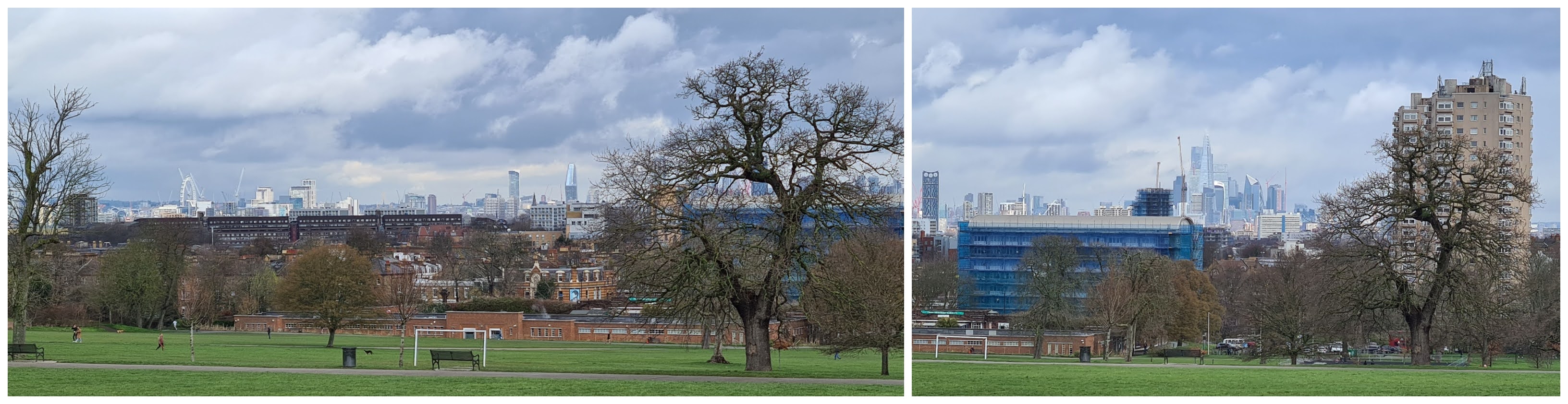
We also took in the view towards central London from the top of the park, where you can see the Shard and most of the other skyscrapers in the city of London. I mentioned that Crystal Palace Tower can be seen, but if you look carefully you can also see the chimneys of Battersea Power Station and the London Eye. We would have liked to have had a ride on the Brockwell Park Miniature Railway, however it only operates on Sundays between March and October.


While all that was happening, the parkrun results for event 537 had been processed and published online. The number of participants was slightly lower than what would usually be expected, which may have been down to the rain early that morning. In total there were 227 participants and 19 volunteers on this occasion. Should you wish to view the course in a little more detail, please feel free to take a look at the GPS data I gathered via my Garmin or take a look at the course fly-by video which was made from that data. Lastly, a big thank you goes out to all of the volunteers that made it all possible.


Related links:

My GPS data (18 March 2023 / Event 537)
The Relive course fly-by video (18 March 2023 / Event 537)


Monday, 13 March 2023

Brandon Country Park parkrun

In the north-west corner of Suffolk, right on the border with Norfolk, is the small town of Brandon. It was previously known as Brondun, and has a modern-day population of around 10,000 people. The River Little Ouse flows through the town. It sits within the area known as Breckland, which naturally features a sandy heath landscape, covered largely in gorse. 


Historically the local area is known for its flint. The flint has been mined here since around 2,600BC and the remains of some of the historic mines, Grime's Graves, are now one of the area's major tourist attractions. There are 433 shafts which cover an area of 91 acres just a few miles outside the town.

The presence of flint led to knapping becoming one of the area's skilled industries. Knapping is the process of shaping flint, this would have sometimes been as a building material, and most of the older buildings in the local area have flint used in their construction and external decoration. Another use of flint was for weapons such as flintlock guns from the 17th to 19th centuries.


The supply of flint was vitally important for the military, and during the Napoleonic Wars Brandon flint was regarded as the best and most reliable. During this period, knappers from Brandon supplied around 400,000 flints per month to the British military. Local businessman, Edward Bliss, made his fortune from mining the flint and selling it onto the army. He used his wealth to purchase 2,500 acres of land just outside the town and created the Brandon Park country estate. The centrepiece of the estate was the mansion called Brandon Park House. The estate also included stables, a walled garden, an engine room, a mausoleum and an arboretum.

In the years following the First World War, the nation's timber supplies were running low. Much of the land of the local country estates was purchased and a huge tree planting operation began, this planting created what we now know as Thetford Forest. The forest covers an area of 18,730 hectares (73 square miles) and is the seventh overall largest forest in the UK. However it can claim the number one spot for being the UK's largest man-made lowland forest. The creation of the forest has changed the landscape considerably, taking away part of the traditional Breckland.


The former country house still stands and is now a grade II listed building. It changed hands a few times over the years, but is now owned by the Catchpole family, founders of Stow Healthcare. The house is now run as a boutique private nursing home where rooms cost up to £1,495 per week. The rest of Brandon Park, which is nestled within the vast forest, is now called Brandon Country Park. Most of the original features are still there including the walled garden and the mausoleum, but it now has additions such as a playground and marked walking routes.

We visited the country park on 11 March 2023 to take part in Brandon Country Park parkrun, which coincidentally fell on the event's official tenth birthday. We had stayed overnight in the Premier Inn at Thetford which is just a few miles down the road, so the journey was nice and simple. There are two onsite car parks which as of March 2023 cost £2 for up to two hours or £3 for over two hours. The country park managers request that parkrunners use the Orchard car park, which means driving past the main car park and the country house. Payment can be made by using the RingGo app or at the pay and display machine.


For cyclists there are bicycle racks within the main car park. Should travel by public transport be required, Brandon does have its own train station. The walk from the station to the country park is just under 2 kilometres. There seem to be a few bus routes around the local area that can get you into Brandon, but they are of course rural services so may be quite infrequent. However you travel, entry to the country park is off of the B1106, I understand it may also be known as Bury Road. Once in the country park, the main hub is adjacent to the car park and here you will find the playground, walled garden and the cafe building. The toilets are located in the rear of this building - when we visited they were open before 8.30am.

Brandon Country Park parkrun takes place over an anti-clockwise one-and-three-quarter lap course. Underfoot features a mixture of forest trails, dirt paths and some sandy paths. An important thing to note is that there are several areas containing protruding tree routes, so care will need to be taken to avoid tripping. With all that in mind my preference is for trail shoes. The course is not 100% flat, my Garmin picked up 51 metres of elevation change. The ups and downs are long and gentle, however I imagine the uphill could be challenging if running at a high effort. Taking part with a buggy would be totally fine, you'd just need to pay close attention to those tree roots and maybe some slightly uneven paths.


The parkrun itself has separate start and finish areas, so upon arrival you are likely to find most of the volunteers milling around the finish area which is on the lawn behind Brandon Park House - if you are visiting and want a pre-parkrun photo with the pop-up banner, head over to this area. However the briefings take place adjacent to the playground, so most of the participants seemed to assemble at that point. Following the briefings, the crowd moved further into the forest to the start area.

The start is on a typical forest country park type of path, so not terribly wide, however the attendance figures here are quite modest so I can't imagine there is ever a problem with overcrowding. In general the first half of the lap is gently downhill, this begins in the forest. However the feel of the course and its scenery changes multiple times on the way around.


After leaving the opening forest section, the path underfoot becomes more sandy, which is of course natural for this area of the country. It's a fairly light coating of sand so it's not like running on a beach. You may also spot flint in the ground. The landscape opens up a little here and the course follows the line of the overhead electricity cables which pass through the northern end of the park.

A left-hand turn at the most westerly point of the course marks the start of the long, gentle uphill. After not too long and a right-hand turn, the course reaches the mausoleum. Edward Bliss had this built as a final resting place for him and his wife. Initially they were both interred here, but were later moved to St Peter's Churchyard in Brandon. The building has the same style of knapped flint that can be found throughout the local area, and is now apparently home to Pipistrelle Bats. After passing the building, the course makes its way towards the formal area at the back of the house, which features almost a full loop of the rectangular duck pond. As you pass through this area on the first lap, the finish can easily be spotted on the grass.


On the first lap only, there's a very cool, wiggly woodland section to negotiate. This leads around the back of the cafe, past the playground and eventually merges into the forest path from the very beginning. The second lap is exactly the same as the first, but after rounding the pond for the second time, the finish awaits. As with most parkruns, the barcode scanners are placed just after the finish line. It is worth noting that the signage and marshalling was brilliant all the way around the course.

As it was the event's 10th birthday, some stones had been painted and scattered around the course for participants to find. One very kind marshal pointed us in the direction of one of them, so we have that as a souvenir of our visit. We'll keep it next to the parkrun stone that I painted a few years ago.


I recorded the course with my Garmin, and the course data can be viewed on my Strava page. That data was also used to create a course fly-by video using the Relive app on my phone. The course was not completely identical to the one on the map on the official course page, so bear that in mind if visiting.

The results were processed a short while later and there had been 121 participants at event 456. This figure was slightly elevated due to the event's 10th birthday celebrations. On a regular week, there would usually be less than 100 finishers. Don't let those modest attendance figures fool you, this is a lovely country park. The forest sections were stunning and the mausoleum adds an extra unique element to the venue.


The post event refreshments are at the onsite cafe, The Copper Beech Cafe. Once we had finished refuelling, we explored the walled garden, which has a 23-metre-deep well as its centrepiece. The playground seemed pretty cool, but the kids were happier exploring the garden so we didn't end up spending any real time there.

At around midday, we'd reached the point where we had to head off, so headed back over to Thetford to continue our mini-break. I'd like to add a huge thanks to the whole team that put the event on and made us feel so welcome.


Related links:

My GPS data (11 March 2023 / Event 456)
The Relive course fly-by Video (11 March 2023 / Event 456)


Saturday, 4 March 2023

Raphael parkrun

In the London Borough of Havering, just outside Romford town centre lies an affluent area called Gidea Park. It consists largely of houses and cottages built to showcase town planning in the style of a 'garden suburb'. Six of these houses are now grade 2 listed. The area was formerly part of the Gidea Hall Estate of which the original 'Gidea Hall' dates back to 1250. It was improved several times over the next few centuries before falling into disrepair and finally demolished in 1720 when a new three-storey mansion was built on the site.

In 1897, the Gidea Hall Estate was purchased by Herbert Raphael who subsequently donated over 20 acres, including a lake, for use as a public park. A further 15 acres of land and an area of water named 'Spoon Pond' were purchased by the council and in 1904 Raphael Park was opened to the public by Sir Herbert and Lady Raphael. Herbert Raphael went on to develop the rest of the estate into the aforementioned Gidea Park (aka Romford Garden Suburb). The new Gidea Hall stood until 1930 when it was demolished.


Raphael Park [it is pronounced: rayfel, but you may also hear it said as rayfels] forms part of a 'green lung' which connects Romford in the south to Havering Atte Bower further north and consists of two distinct sections. The southern area is the more formal of the two and contains a variety of trees, shrubs and plants, plus a lake known as 'Black's Canal'. The northern section is more sports focused and is mostly comprised of a large, open, grassy plateau which is used for sports pitches, tennis courts and a playground. On 2 May 2015, Raphael Park became home to a free, weekly, timed, 5k event called Raphael parkrun. Like all parkruns, it is open to all abilities, including walkers and wheelchair users.

Travel by public transport looks simple enough. There's a train station at Gidea Park which is served by National Rail and the Elizabeth Line, plus the 174, 347 and 498 buses stop just outside the park's southern entrance. Anybody travelling by bicycle could secure their stead to one of the bike racks dotted around the park, but it's much easier to simply lock it to the railings within the bandstand which is located in the southern section of the park and is also used as the event's base.


We visited the venue in 2015 and again in 2023, and on both occasions parked on a road called Parkway, which is restriction-free and is on the north-east side of the park. There is also a car park opposite the southern entrance to the park. This car park serves both Raphael Park and Lodge Farm Park, which is just across the road. It is free-of-charge but there is a maximum stay of 5 hours on a Saturday or 3 hours if visiting during the week.

There are two sets of toilets in the park. Unfortunately the ones that are closest to the parkrun meeting point do not open before the run and the second set, which are open before the run, are located right at the far end of the course (500 metres away, next to the playground). So plan accordingly! When you enter the park, you'll more than likely pass through one of the grade 2 listed gates. The first-timers and tourists briefing takes place next to the bandstand, this is followed by the full briefing that takes place at the start which is on the path adjacent to the bandstand. The participants are then sent off on their 5 kilometre jaunt around the park.


The entire course is made of smooth tarmac which makes this venue a very good choice for a spot of buggy running - which is exactly what we did on our first visit. It looks like it would be fine for wheelchair athletes/users too. The course is largely, but not completely, flat so should be reasonably good for anyone looking to put in a good effort. With all that in mind, road shoes are the way to go at all times of year. The 5k course is made up of two full clockwise laps, followed by a third, shorter lap. The general rule is to keep left at all times.

The full lap starts off by heading south towards the southern tip of the park which is ever-so-gently downhill and ends with a sharp-ish right hand turn (where we collected hi-fives from the marshal on each occasion) onto the path adjacent to Black's Canal (the lake). Incidentally, the lake was created in the late 1700's by damming and redirecting a tributary stream. The path runs directly along the edge of the lake and there is no fence so it makes sense to stay sensible on this stretch, especially on the first lap when it is congested. Also bear in mind that there may be people fishing here, if so their fishing equipment / rods may take up part of the path (see photo).


This path leads the participants past the bandstand where there is good support from the finish funnel crew as they await the finishers. It then heads along to the northern end of Black's Canal and then up a short, sharp incline which weaves around until emerging in the northern half of the park. With the large open playing fields to the left, the course follows the tarmac path until it reaches the tennis courts. At this point a marshal (or arrow. or both) will be visible to direct the runners to turn to the left, passing alongside the tennis courts.

At the far end of the tennis courts is an adjoining playground which must be circumnavigated before heading back along the opposite side of the courts. You may notice that the tennis courts and playground are lower level than the paths - the reason for this is that they have been constructed within the area that was formerly a water feature called 'Spoon Pond'. This feature was never purposefully removed. Apparently, the drainage system for the new housing adjacent to the park was so efficient that it lowered the area's water table and the water feature rapidly emptied.


The course now heads back towards the southern half of the park where there's a slight incline heading back towards the start area. With the first lap complete, it is now a case of simply following the same route on the second lap. The third, and final, lap is somewhat shorter than the first two and very simply just cuts out the northern section of the park. At the top of the short, sharp incline the route just turns to the right and heads back along the final part of the original lap. Upon reaching the start area, the finish straight peels off to the right.

On our first visit, barcode scanning took place within the bandstand, but the second time around it took place adjacent to the finish. I recorded the GPS data of the course on both occasions. On our first visit, the start was a little further along the path and the finish had a slightly different set up. So if reviewing the data, the 2023 version is of course the most up-to-date. There is also a Relive course fly-by video made from the 2023 GPS data, which can be viewed on YouTube.


For post-event refreshments, the first option is Raphael's - it's more of a restaurant than a cafe and is very nice inside. The other option in the park is to head to the far end where there is a kiosk called 'Milli's Coffee House' next to the playground. There was plenty of outdoor seating, but it does not have the option of sitting indoors.

On both occasions the results were published shortly after the event. Our first visit was at event 12 where I ran with my daughter in the running buggy. Our 2023 visit was at event 331 where I was run-walking (mostly walking) with my son. In terms of numbers of attendees, expect somewhere between 250 and 300. There were 259 participants at event 331.


The formal part of the park is very nice, and we had a wander around on both visits. We also ended up in the playground both times around. The weather was nicer during our 2015 visit as it was summer, and we were still in the park in the afternoon. In 2023 it was pretty chilly so we didn't stay as long.

If you are looking for something else to do post-event, it's worth popping over the road to Lodge Farm Park, where there is a miniature railway (not open during the winter). We left the park with great memories of our visits and would not hesitate in going back again in the future. 


A final thanks goes to all of the volunteers who made us feel so welcome on both visits.


Related links:

My GPS data (Event 331 / 4 March 2023)
The Relive course fly-by video (Event 331 / 4 March 2023)

My 2015 GPS data (Event 12 / 18 July 2015)(Note: Slightly different start and finish points)


Note: The original of this write-up was published in July 2015. It was updated in March 2023.


Related Posts Plugin for WordPress, Blogger...