

In around 1790 the estate was renamed Oak Hill and in 1810 was bought by Sir Simon Haughton Clarke who was a fellow at the Royal Horticultural Society and apparently the seventh richest man in England at the time. He built a vinery and the estate became quite famous for the grapes and pineapples that it produced. The railway arrived in 1850, but unlike some other areas on the fringes of London, there was no rush to build housing, and the area remained rural right up until the 1920's. The last private owner of the Oak Hill Estate passed away in 1928 and the parkland was bought by East Barnet Council in 1930.


In 1932 the mansion and part of the grounds became home to Oak Hill College, which is an Evangelical Theological College. The following year the rest of the grounds opened as a public park called Oak Hill Park. Adjacent, and contiguous with the park, is a 10 hectare area of ancient woodland, Oak Hill Wood, which is managed by the London Wildlife Trust. It has been a local Nature Reserve since 1997 and many of its trees are descendants of those used in the building of St Albans Abbey.

The park itself is beautifully landscaped. It features a bowls green, football pitches, cricket pitch, tennis courts, outdoor gym, multi-sports court, children's play area, gardens and a cafe. However, for me, the stand-out natural feature of the park is the meandering waterway called Pymmes Brook. This is enhanced by the Weeping Willow trees that grow along its banks and make it very picturesque.
On 27 August 2011 the park became home to Oak Hill parkrun. This is a free, weekly, timed 5km event which takes place on Saturday mornings at 9am. It is open to all abilities including wheelchair users and those who wish to walk. I first visited this event on 6 July 2013 and took part in event 96. This write-up is from my second visit which was on 9 March 2024 at event number 589.

Being in London it is pretty well connected transport-wise. The 184 and 382 buses both stop on the roads alongside the park. If travelling by National Rail, Oakleigh Park is the best station to head for, and is just 1 kilometre away from the park. It is served by Great Northern Railway trains from King's Cross and Moorgate through north London and onwards towards Welwyn Garden City. If using the London Underground, taking the Piccadilly line to Southgate station or the northern line to Totteridge and Whetstone would be the options. Please note they are both around 2.5 kilometres (1.5 miles) from the park. Cyclists can secure their bikes to the cycle racks next to the cafe or to one of the fences near the parkrun meeting area.
There is a free-of-charge onsite car park located at the south-east corner of the park. It can hold about 55 vehicles and this includes the spaces for blue badge holders. It is very likely that the car park will be full shortly before the parkrun starts, so if looking for an alternative place to park, most of the nearby side streets are restriction-free and can be used. I'd just note that many of the houses have driveways, so this does reduce the amount of space available for on-street parking. The only specific request on the parkrun page is that attendees should not park on Parkside Gardens, East Walk or West Walk. There is an additional car park on Osidge Lane.
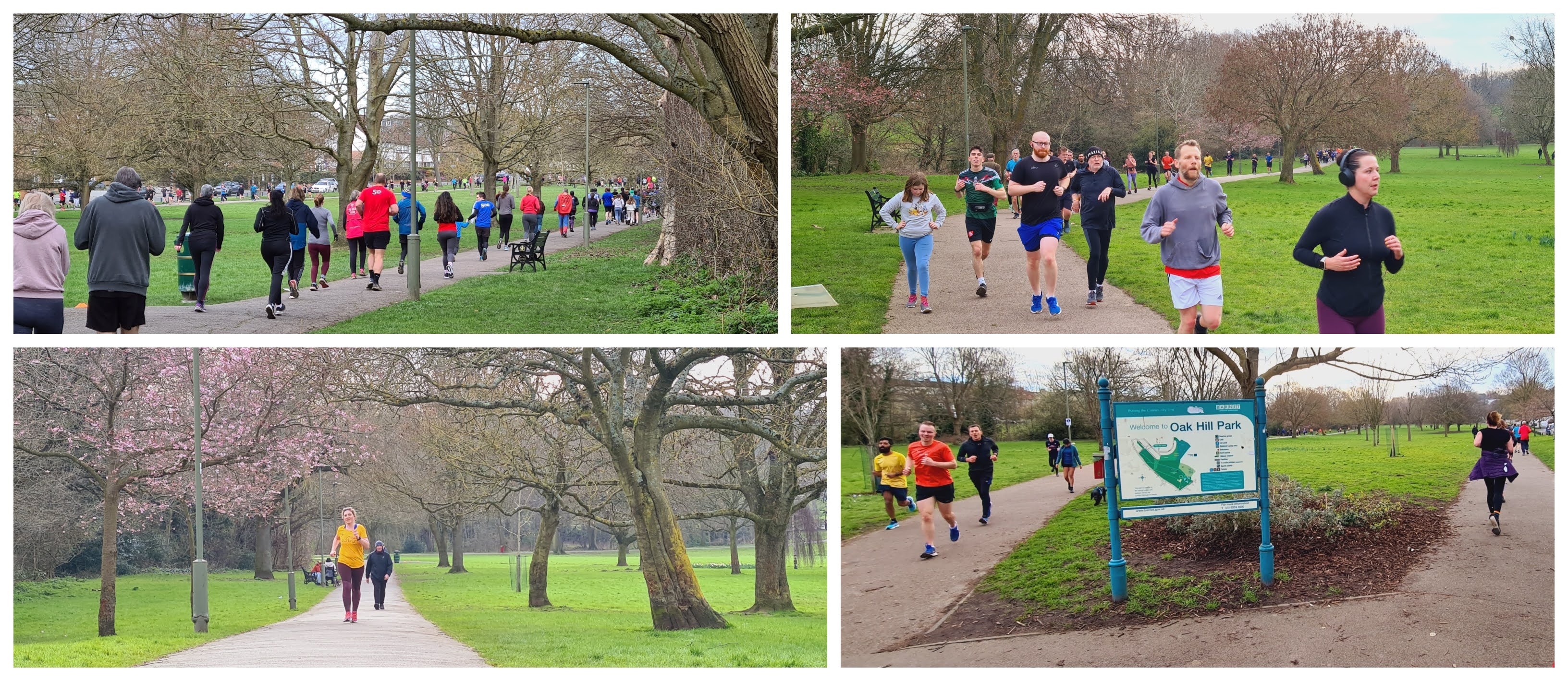
Once in the park, the parkrun meeting point can be found towards the southern end, in the small area in-between the tennis courts, bowls green, outdoor gym and the children's playground. It's also quite close to the car park. Should you feel the call of nature, there are on-site toilets located on the side of the cafe building which is just a minute or two away from the meeting point. The toilets should be open at around 8am, which is also the time the cafe opens. The first timer and main briefings are held in this area, and once completed the participants are led along the path to the start line.
The parkrun takes place over a two-and-three-quarter lap course, with the surface underfoot being 100% tarmac except for the finish line which is on grass. Those pushing buggies and wheelchair users should be fine at this event, but please note the next section... Given the name of this park, it will be of no surprise that this is not a flat course. If taking part on the standard course it's not quite as hilly as it could be where the elevation change over the 5k coming out at 31 metres on my GPS readings. If you happen to visit on a day where the B course is being used, then you will find things considerably hillier with the GPS data that I have showing the elevation change being around twice as much. My understanding is that the B course would usually be called into action if the path alongside Pymmes Brook becomes flooded/waterlogged.

The course description below is for the standard course (please note there is a totally different starting point for the B course, which is 3-and-bit-laps - also a new B course was introduced in early 2024). The parkrun starts on the tarmac path (part of the Pymmes Brook Trail) which runs alongside Pymmes Brook and is about 400 metres away from the meeting and briefing area, but as mentioned above, everyone walks down to the start together so if you are a first-timer here, just follow the crowd. The initial section involves heading along this path to the north-west. There is a quick left-then-right turn as the route crosses the brook after about 200 metres. The course then follows the path, which rises ever-so-slightly in elevation, all the way to the north west tip of the park where there is a marshal and a sharp left hand turn.
Now heading to the south alongside Church Hill Road, the route undulates gently, first with a gentle dip which is followed by another very gentle incline. Upon reaching the next marshal point, there is another chicane-style junction to negotiate, and after the quick left-then-right the course emerges onto a narrower path with quite a pronounced camber. This section of the park overlooks the football fields where the Pymmes Brook, Weeping Willows and the start area can be seen. A bit further in the distance is Oak Hill Wood, and if you are lucky you may even catch a glimpse of the former estate's white mansion nestled on the hillside. This path is where you will find the steepest of the inclines, but even that is not overly steep or long, the maximum incline reported on my GPS data was 3.7%.

This path also features the highest point of the course, and from there it is, of course, all downhill. The route passes the playground, meeting point, and the finish line and crosses another bridge where the course rejoins the Pymmes Brook Trail and follows the course of the river until reaching the start point. The full lap is 1.8 kilometres in length, and from this point it is just a case of following the same paths for the second full lap and for three-quarters of the third lap, at which point you simply enter the finish funnel which is placed just off the tarmac path on the grass.
It is worth noting that the almost-three-lap course means that there is plenty of interaction between participants as those towards the front reach and overtake those towards the back. While this is great, it does mean that you need to stay aware of what is happening around you, especially on the narrower sections of path.

Barcode scanning, as you'd expect, takes place within this grass area at the finish line. Once all of the participants have completed the 5 kilometre course, the post-parkrun refreshment gathering takes place over in Oak Hill Park Cafe. The cafe has its own soft-play area for very young kids, but there is a fee to use it. I went to the cafe on my first visit, but didn't go on my second visit as we had other plans, so I can't comment on the quality. However, it serves everything you would expect including full breakfasts. They also specialise in Polish dishes, so that may be worth investigating if visiting. There is also a 'pay and play' golf course in the park which has a kiosk that sells refreshments from about 10am.
As I have noted above, I have GPS data of the standard course which I recorded with my Garmin. There is also an accompanying Relive course fly-by video which can be viewed on YouTube. I also managed to get hold of a GPS file of the new 2024 B course, so I have uploaded that onto my Strava account and also created a fly-by video for that one too. For the record, the GPS data for the old B course is also available to view. Feel free to check them out if you are looking for some extra course information.

The results were published a short while later and there were 341 finishers at event 589. As a general guide, as of early 2024 the event tends to attract around 300 participants each week. It certainly has grown since my first visit, on that day in July 2013 a new attendance record was set when they had 75 participants.
We had a great morning in this lovely picturesque park in East Barnet. The volunteers and locals had been extremely welcoming and a huge thanks goes to everyone involved.
Related Links:
- Oak Hill parkrun GPS data (standard course - 9 March 2024)
- Oak Hill parkrun Relive course fly-by video (standard course - 9 March 2024)
- B course GPS data (NEW B course as of 2024)
- B course Relive course fly-by video (NEW B course as of 2024)
- Old B course GPS data (from October 2023 - no longer used)
- Old B course Relive course fly-by video (from October 2023 - no longer used)