Showing posts with label hertfordshire parkruns. Show all posts

Wednesday, 1 May 2024

Aldenham parkrun

Aldenham is a village and civil parish in Hertfordshire which has a population of around 10,000 people. The name derives from Eladeham, which is said to mean 'old home' or 'Ealda's home'. The ownership of the Manor of Aldenham seems to have been heavily disputed for many years with both the Abbot of St Albans and the Abbot of Westminster claiming the land as their own. The Manor was surrendered to the crown upon the dissolution of the monasteries and it was held by many families over the subsequent years. A manor house was built called Wigbournes and this was replaced by Aldenham House, which still stands and is now in use as a private school.


The manor contained several areas of common land and the largest of these was Aldenham Common, which sat at its southern end. In 1793, 68 acres of Aldenham Common were sold to the Grand Junction Canal Company. The water levels of the canal, which is actually a few miles to the west, needed to be managed, and the company required a large body of water to do this. The common had a stream running through it called Tykeswater, so a dam was constructed out of clay and gravel, and a reservoir (Aldenham Reservoir) was hand dug. At the time of its construction, the French Revolutionary Wars were taking place and some of the French prisoners of war were recruited to provide much of the manpower required for the project.

By the start of the 20th century, the reservoir had become popular for boating, fishing and swimming. Just before the start of the Second World War, the dam, which suffered from erosion, had been strengthened with the construction of a concrete wall. This coincided with an agreement made between the canal company and the local water company, to allow water to be drawn off when other local water supplies were running low. A consequence of this agreement was that some of the recreation activities had to cease in order to reduce the risk of the water becoming contaminated. The boating activities of Aldenham Sailing Club, which had been based at the reservoir since the 1920's, were allowed to continue. In the early 1970's the agreement came to an end and the reservoir was no longer required for public water supply.


The local council still owned some of the land adjacent to the lake, and in the mid-1970's they made the decision to create a recreational facility in the form of a country park. The park features a rare breeds farm, nature trail, adventure playground, a Winnie the Pooh 100 Aker Wood walk, toilets and car park which from what I understand were all originally free-of-charge. I should also mention that the park also has camping and glamping facilities. The reservoir was (and still is) privately owned, but the council took out a lease on it and it essentially became part of the park. In 2012, with the period of austerity in full flow, the council decided that it could no longer fund the country park, and put out a tender for the park's management. This tender was won by Aldenham Renaissance and they have managed it ever since. However, this resulted in charges being introduced for the farm, playground and car park.

In June 2015, the country park became home to Aldenham parkrun, which is a free, weekly, timed 5km event and is open to all abilities including those who wish to walk. We first visited Aldenham Country Park in December 2015 where I took part in the parkrun with my daughter in the running buggy. I wrote about it in my original Aldenham parkrun blog, but as we were revisiting I thought I'd take the opportunity to create a new write-up. For the record, there haven't been any significant changes since my first visit and the course is basically identical.


On both visits, we used the car to reach the event and parked in the on-site car park. The car park has a number plate recognition system in place and will calculate the charge for you. Thankfully it is pretty simple. The current arrangement as of 11 May 2024 is that there is a flat fee of £5.50 for using the car park. Please note, the previous arrangement where parkrunners could pay a reduced rate if leaving before 10:30am has now been withdrawn. The payment is made by using a contactless payment at the exit barrier upon leaving, so make sure you have your payment card or mobile payment app to hand. If you need to pay by cash, this must be done in person at the farm shop or kiosk and they will then give you an exit code. Volunteers qualify for free parking up until 11am (volunteers should liaise with the day's run director regarding this).

For anyone using public transport, the nearest national rail train station is Elstree & Borehamwood, which is approximately 3km away from the country park. The closest bus stops are on Watford Road and seem to be served by the 306 and 306A services. From what I can see the 306 runs from the train station, so it looks like a good option for anyone that doesn't fancy walking from the station. Alighting at the bus stop near the Bargeecha Indian restaurant will allow access to the country park via the Watford Road entrance and from there the footpath can be followed around to the car park and parkrun meeting area. For anybody cycling, there are some bicycle racks in the car park. The meeting area for the parkrun is towards the southern end of the car park, near the farm entrance.


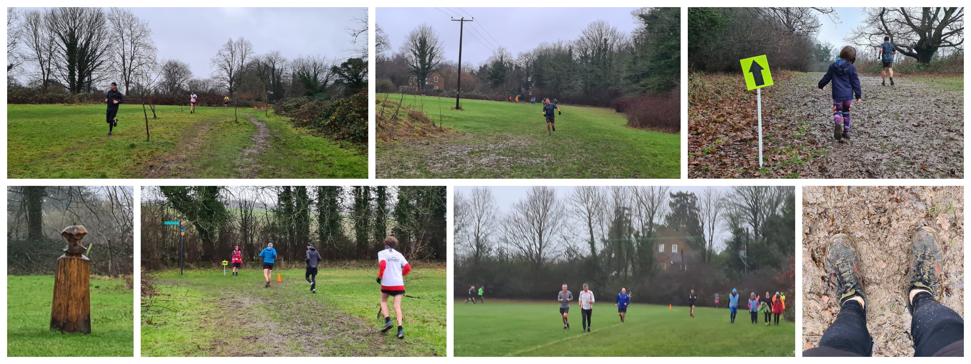
The first timers' briefing is held at the meeting area and this is followed by the full briefing once everybody has lined up at the start line. The parkrun takes place over two, flat, non-identical clockwise laps around the perimeter of the reservoir, and underfoot contains a mixture of surfaces which is predominately made up of a forest-style trail path, but also includes some tarmac and a compacted stone surface. There are some sections of the path that are very uneven due to lots of large stones and rocks protruding from the ground, and it can also be a little muddy. With this in mind I'd lean towards this course being best suited to a trail-style shoe, even in the summer months. Buggy runners should be absolutely fine here, but it may be a little bumpy for the occupant during those stony sections. I'd say committed wheelchair users will get around the course, but again I would highlight the uneven surface in the section with the stones and the potential for muddy sections during the wetter seasons.

The start line is formed in the car park itself and at 9am everyone is sent off in a northerly direction for approximately 150 metres to the far end of the car park where the course joins the start of the park's reservoir loop path. Incidentally, following changes to the parish boundaries in the 1930's the reservoir actually sits within the neighbouring parish of Elstree & Borehamwood, resulting in over 90% of the course sitting outside of the parish of Aldenham.


After crossing a small bridge, the course continues by heading along the top of the dam. This path is tarmac and there are some quite noticeable cracks in the surface. This gives some clues as to the current state of the dam, which is in need of repair. In fact, in 2020 the dam was assessed as being at high risk of complete failure. As a consequence, the water level was lowered by around a metre to help prevent further deterioration. The reduced water level had a knock-on effect for the sailing club, as it was deemed unsafe for sailing to continue. So, for the time being the boats have gone.

Once the course reaches the far end of the dam, the path turns onto the forest-style trail where it continues heading around the reservoir's perimeter. The stony section of path can be found around this section of the course, so watch out as the rocks can be quite large in places. Continuing on, the path continues along through the thin strip of woodland that separates the reservoir from the adjacent road. The width of the path changes from time-to-time, with some short sections even going down to a single file path. The reservoir is not always in sight, but the overall experience is quite pleasant. There aren't many marshals out on the course itself, but there is one when the course reaches its second small bridge.


The course then continues away from the reservoir through a slightly thicker patch of woodland where it eventually passes alongside the farm and you should get a glimpse of some of the animals. The end of this path is where the non-identical part of the lap starts. On lap one, the parkrunners are sent to their right which follows the inner curve of the reservoir. This part was especially memorable as the path had a section which flowed from left-to-right in a really nice way. It can get a little muddy towards the end of this part but before you know it, the route pops out of the trees and rejoins the opening section, again heading along the edge of the car park. The course then follows the same route until reaching the end of the path next to the farm.

At this point, the course turns left and heads through a magical, green leafy tunnel. At the end of the tunnel the course feeds into the southern end of the car park, where it continues along its edge until reaching the original start point, which is now the finish line. Barcode scanning takes place in the car park and with that done, the parkrun is complete. Post event there are two options for on-site refreshments; firstly there is the clock house kiosk which is next to the finish and offers a basic selection of drinks and snacks. The other option is on the opposite side of the car park and is called Rustic Rhubarb, this cafe has a wider selection of food including full cooked breakfasts.


We had brought a packed lunch with us, so headed over to 100 Aker Wood for a picnic, where we also had a game of Pooh Sticks and explored the trail. As mentioned above, there is also a farm and a playground here, but there are entry fees for both of these and in the end we decided against the additional expense. The country park extends to the north and at the far end there is an avenue of trees dating from 1880 which formed part of the grand entrance to Aldenham House.

It wasn't long before our parkrun results came through, which showed that there had been a turnout of 120 participants at event 391. This number of attendees is typical for this venue, although it is also quite normal for the attendances to drop down into double figures. I recorded the course with my Garmin and you can see the GPS data on my Strava account. I also used the data to create a course fly-by video with the Relive app, and this can be viewed on YouTube.


I have also read that the local council recently (2023) approved a proposal set out by the reservoir's owners to construct some commercial warehousing nearby, and the income generated from this will finance the much-needed repairs to the dam, which is obviously good news. However, if this results in the footpath closing during the works, this could potentially affect the parkrun so remember to check Aldenham parkrun's news page and social media feeds before visiting for the latest updates.

Finally, despite being a little damp and chilly, we really enjoyed our second visit to Aldenham Country Park. We were made to feel extremely welcome by the volunteers, including getting a fist-bump within seconds of getting out of the car by a fellow Steve(n)! So a huge thank you goes to everyone involved in putting the event on.


Related Links:


Sunday, 15 January 2023

Leavesden Country parkrun

Leavesden is a residential area in the north of Watford, Hertfordshire, and is home to around 6,000 people. It was a hamlet for much of its early history and remained largely agricultural right up until the 1930s when a number of housing developments were built. Just after the outbreak of the Second World War, Leavesden Aerodrome was built. Its main purpose was a base for the manufacture of the Handley Page Halifax heavy bomber and the de Havilland Mosquito fighter-bomber aircraft. Both of which contributed greatly to the war effort. Post-war, the site specialised in aircraft engine development largely by de Havilland and then Rolls-Royce, who eventually moved their operations elsewhere by the early-nineteen-nineties, and the site then closed completely.

The old airfield was not vacant for long, as Eon Productions leased the site, and the dis-used aircraft hangers were transformed into filming studios for the James Bond movie, GoldenEye. With the filming complete, the site was officially named Leavesden Studios and it quickly became popular within the film industry. Eventually the studios were taken over by Heyday Films, in order to start production on the Harry Potter series of films, and this arrangement stayed in place until Warner Bros. formally purchased the site in 2010.


Over the years many successful films have been shot or partially shot at Leavesden including Star Wars: The Phantom Menace, Batman: The Dark Knight, Inception, the Paddington movies, and Spiderman: Far From Home. Since 2012, most people that visit the area are probably visiting the Harry Potter studios, or to use its full name, The Warner Bros. Studio Tour London - The Making of Harry Potter. The attraction is home to a large number of the sets used in the Harry Potter series of movies, which were also filmed here. The visitor attraction can accommodate up to 6,000 visitors per day, and it is of course very popular with fans of the books and films.

Moving back in time to the 19th century. In 1868 the Metropolitan Poor Act was passed and this lead to the formation of the Metropolitan Asylums Board (MAB). Its job was to assist London's sick and poor, and it did this through setting up institutions, workhouses, hospitals and asylums for 'quiet and harmless imbeciles'. One of these was established in Leavesden and it was originally known as 'The Leavesden Imbeciles Asylum', or possibly 'Leavesden Asylum for Idiots and Imbeciles'. It went on to become known as Leavesden Mental Hospital in 1920, and then, from 1937 as Leavesden Hospital.

The asylum contained space for thousands of patients, along with further space for over 600 orphans. It had its own school, gas works and sewage treatment system, and also a 42-acre farm complete with livestock. One of the asylum's inmates was suspected of being the infamous Jack the Ripper, however as the Ripper's identity has never been proven, it is not known if it was indeed him. The hospital is credited for its pioneering role in understanding, recognising and treating mental health conditions. Leavesden Hospital eventually closed down in 1997. The original hospital admin block survived and has been transformed into private housing. Some new housing and retail outlets have been built. The rest of the original grounds have now been transformed into Leavesden Country Park.


The country park covers an area of 27 hectares and very much focuses on the heritage and history of Leavesden, notably the hospital, the aerodrome and the film studios. You'll find beautifully restored Edwardian features and a remembrance garden. There are sculptures on display, all of which you will see if you follow the heritage trail. I will note here that the park itself is split into several separate sections which are intersected by a number of roads. Most of the heritage is found within the central parts of the site which sits to either side of College Road. Also, almost the entire park sits within the civil parish of Abbots Langley, not Watford.

The reason we had visited was, of course, to take part in Leavesden Country parkrun which has been a weekly fixture in the park since October 2022. The parkrun takes place in the most northerly section of the country park, which contains areas for sports, the park's main playground, a YMCA Community Hub, and some woodland. The YMCA building contains toilets, but please note that they do not officially open in time for parkrun. The parkrun page says they open at 9am, while the park's official website says 9.30am. Either way, if a toilet is essential you'd be well-advised to make a pit-stop during the journey. We stopped at the Watford North branch of McDonalds which around 2 kilometres (1.2 miles) to the south of the park. For the record, the park's toilet was open before 9am on the day we visited.


The official arrangement for car parking is detailed on the event's course page and you should really take care to read and understand this before visiting. Essentially the park has free car parking facilities for all park users, however the main car park itself is not huge. There are other users of it on Saturday mornings, so the arrival of parkrun (and a load of extra vehicles) seems to have placed it under quite a bit of strain. The official parkrun page directs parkrunners to initially use the part of the car park closest to the main vehicle entrance. Once this section is full, parkrunners are then free to use the main car parking facilities within the central point of the park.

If you are local enough to be able to cycle or walk, this would definitely be the way to go. There are bicycle racks outside the YMCA building. Equally if you are travelling from further away and can make public transport work, that would seem to be a sensible idea. The course page says the number 20 bus stops near the park. If you are arriving in the area by train I would expect you'd alight at either Kings Langley (1.8 miles) or Garston (1.7 miles), but as you can see, they are both a fair distance away. However the walk from Garston to the park does go straight past the aforementioned McDonalds. 


The meeting point for the parkrun is just outside the YMCA hub and playground where the briefings are held. The starting point is outside the multi-use caged sports courts. The course itself is almost a 50/50 split between grass and hard paths. When it's nice and dry underfoot you can confidently use road shoes, but once the wetter weather sets in this is definitely a course for trail shoes. The course is not totally flat, but neither is it hilly, My Garmin GPS data picked up 25 metres of elevation change (59 when imported into Strava). I think I'd categorise it as gently undulating. Buggy running is fine here, although if you don't like pushing the buggy through squelchy mud it's probably best to go in the summer. 

The route features a start tail, then three clockwise laps, all rounded off with a slightly shorter finish tail. The lap is split into two loops with a short two-way section joining them together (like an hourglass). The first loop takes place on the hard standing paths which meander very pleasantly through the park's woodland area. If visiting in December/January look out for the annual Fairy Trail where you'll find fairy doors and other hidden items nestled within the trees. At the end of this section, there's the short two-way section. Just keep left here to avoid collisions and take care to avoid barging past other people.


The course then enters the grass section at the north-east corner of the park. The first half goes around the Heritage Orchard where if you look carefully there is a wooden sculpture of an apple (half-eaten). The grass section continues into the area which contains the park's full-size football pitch. Following the perimeter of the field takes the participants to the two-way part and back into the woodland walk section. Once three full laps are complete, the course leaves the loop and heads back over towards the playground where the finish line can be found. Barcode scanning takes place right next to the finish.

There were ample marshals out on the course and plenty of signs and cones placed in all the right places, so navigating around the course should be nice and simple.

Once all of the morning's participants have completed the 5km, the team retreat to the YMCA Woodlands Cafe YMCA for the weekly post-parkrun refreshments and social. It had been pouring with rain all morning, so we were looking forward to some warm drinks and had fully intended to join them in the cafe. However, my four-year-old son fell face-first into a large puddle about 300 metres before the finish line and he was soaked from head-to-toe. We hadn't brought a full change of clothes for him, so we had to abandon the plan and head home a little earlier than originally planned.


I did manage to have a quick look at the heritage trail before leaving, while I didn't find all of the sculptures, I did spot most of them. I also found the Covid-19 Snake, which started out simply with children placing painted stones down during the lockdown period in 2020. The Three Rivers District Council set these stones in concrete as a permanent feature. Another feature to look out for is Arbi the Tree, found in the playground. I believe this name was given by the With Me Now podcast, so it was fun to see it! If you want to hear the With Me Now podcast profile of the venue, check out episode 228 (also on Spotify, Apple and Ko-Fi).

The results for event 12 were published shortly after the finish and 95 people had taken part. This number seems to be about spot-on the expected amount now that the initial rush of tourists has eased off. The venue sits outside of London, but within the M25, so is included in the London+ set of venues. The GPS course data and the Relive course fly-by video can both be found via the links below. Lastly, the volunteers really were great when we visited, so I'd like to add a huge thank you to them all for making us feel welcome and for standing out in the miserable weather while we slid and splashed around the course!


Links:

My GPS data from event 12 (14 January 2023)


Sunday, 7 July 2019

Jersey Farm parkrun

It would be impossible for me to write a blog about Jersey Farm parkrun without first giving mention to Heartwood Forest parkrun (my blog) which was the original parkrun venue in Sandridge, Hertfordshire. I visited the village back in September 2017 and really enjoyed the run which took place through the hundreds of thousands of saplings which are currently growing in the newly created forest. Sadly the following summer it was announced that the event could not continue to take place at Heartwood Forest and the search for a new venue began.

As it worked out, the team didn't have to look too far for an alternative, as less than a kilometre away from the original venue is another area suitable for a parkrun, and this is of course Jersey Farm Woodland Park. When the announcement came that this was to be the new venue, the parkrun touring community got very excited indeed as it meant that those wishing to become 'alphabeteers' could now 'get their J' without leaving the mainland.

jersey farm woodland park

The 55 acre park which is home Jersey Farm parkrun was formerly part of the estate owned by the founders of the neighbouring village of Marshalswick. As the name suggests, the land's previous role was as a farm, but historically it was called Evans Farm, and covered 309 acres. In the 1930s a well-known tuberculosis researcher, Dr Corner took over the farm and renamed it Jersey Farm after his heard of Jersey Cattle.

The original farmland was eventually sold with much of it being developed into housing, and Jersey Farm is now a residential neighbourhood within the civil parish of Sandridge. During the redevelopment, proposals were submitted to transform the area of the country park into a school sports field with accompanying floodlights etc. This proposal was fought and won by the local 'Major Open Spaces Preservation Association' (MOSPA) and the land was subsequently turned in the country park.

start / finish area

The first tree was planted in 1991 by the Mayor of St. Albans and during the years leading up to the Millennium a total of around 10,000 native trees were planted by volunteers from the local community. The park is not entirely woodland and there are large sections of open meadows which are rich with long grasses and wildflowers, providing the perfect habitat for many species of animals and insects. The most endearing of these is probably the Skylark, which nests within the long grass.

We visited Jersey Farm parkrun on 6 July 2019 and took part in event number 34. The woodland park itself does not have any facilities at all, including parking. I found the best place to park was in the free car park at Sandridge Village Hall which comes with the added bonus of having public toilets (this the same car park I used when I visited Heartwood Forest). Finding the country park from the centre of the village is the next task...

start / opening section

There are many entry points into the park, but from the main road in the village they are not easily identifiable. We entered via the entry point at Highfield Road but due to the nature of the landscape, it's not totally obvious where the start area is. So if approaching from the village I would stay on the main road for a little longer and use the entry point at St. Helier Road instead where the main path will lead you right into the meeting area which is on open grass at the highest point of the park. If you approach from the southern side of the country park, the entrance on Sandringham Crescent leads directly into the meeting area.

If you were trying to reach the venue by public transport, the closest train station is St Albans City, but that is still about 2 miles away. The Jersey Farm parkrun Course Page advises that there are some bus services (304 / 305 / 657) that will help complete the journey, if required. If cycling there are no proper cycle racks on-site, but you may be able to find a fence or post to secure it to. Incidentally there are some cycle racks at the Village Hall car park, but they are not that convenient unless you plan to go to the post-event coffee venue afterwards, in which case it could be a decent option.

bridleway / outer-loop

There are a couple of different course options used here, both run in a clockwise direction. The summer route essentially has a mini-loop followed by two slightly different laps whereas the winter route is run on two identical laps which avoid the more sensitive inner areas. Either way you'll find the course is very well marked out with marshals in all the right places. The start was in a slightly different position to usual when we visited so as not to disturb the nesting Skylarks.

The venue's terrain is of the off-road variety, so while road shoes were fine for when we visited, you will certainly be looking at using trail shoes during the winter or following other particularly wet periods. As far as the elevation is concerned this an undulating course with the ups and downs generally being fairly gentle, but frequent with very little flat ground. My Garmin recorded a total elevation gain of 59 metres.

inner-loop

The outer-loop (used for both summer and winter courses) is run on a fairly narrow bridleway so you'll need to keep an eye out for horses. It spends most of its time meandering through the different woodland plantations and these generally take their names from their relative compass position from the centre of the park, EG West Plantation, North Plantation etc. However one of them is called Bill's Wood - This is named after Bill Morris who formed the aforementioned MOSPA without whom this beautiful park would not exist.

 As we were running on the summer course, at the end of the outer-lap we transferred to the inner-lap. This is run next to and through the open meadows which cover the central areas of the park. There was a particularly memorable section where the grasses had grown so long that there was barely any path to follow - fortunately there were some cones placed along here to help lead the way through. My daughter loved running through that section and I have a feeling my son enjoyed being pushed through even though I annoyed him by trying to keep the grass out of his face.

inner-loop

It's worth looking out for the view at the northern end of the course where you can see across to St. Leonard's Church down in the centre of the village. It is partially built from recycled Roman brick, possibly from the stockpile held by the abbots of St. Albans, and is thought to be almost a thousand years old. Also look out for the Burma Star Association memorial stone which is just alongside the course at the southern end of the park.

There is a section that is used on both laps so you may find yourself lapping or being lapped by others. It gets as narrow as a single file path at times so be mindful of your fellow runners and walkers during this part. This leads into the final part of both laps which is uphill on a gravelly/stony section of path. I was pushing a buggy and had my daughter with me so we pretty much walked it on both laps, but I imagine it would be a bit of a slog at the end of a decent hard effort.

towards the end of the lap

The finish is found back up on the open grass at the top of the park and barcode scanning all takes place right next to the finish line. The team then move down into the village for post-event coffee - the official webpage says this will be either the Heartwood Tearooms or The Potting Shed. We had other arrangements so after letting the kids have a quick play in the playground next to the car park, we headed back home.

The results soon came through and 183 people had participated in the day's event. This was almost spot on the official average number which as of 7 July 2019 stands at 180.2. This number is of course boosted due to the large number of parkrun tourists ticking of their J, but the venue is truly fantastic and deserves recognition for being much more than just another letter on somebody's list.

finish area

You can view my GPS data of the course we ran on the day via my Strava account, just bear in mind the start was slightly adjusted for the Skylarks so it may be slightly different at future events. Plus you can see the Relive course fly-by video which I have uploaded onto YouTube.

Related links:


Sunday, 22 July 2018

Letchworth parkrun

In the north of Hertfordshire right next to the border with Bedfordshire you will find the world's first Garden City. I am of course talking about Letchworth, or to give it its full name, Letchworth Garden City. The town was founded in 1903 by social reformer Ebenezer Howard and now has a population of around 33,000 people.

letchworth garden city

The garden city movement's principals were based around combining the advantages of cities and countryside while eliminating their disadvantages. The town is famous for having the UK's first roundabout, formally known as Sollershott Circus. It also has the UK's largest colony of black squirrels which are grey squirrels with melanism (the development of the pigment melanin - it is the opposite of albinism).

I visited on 21 July 2018 to take part in Letchworth parkrun which is based at The Grange recreation ground at the northern tip of the town. The recreation ground is essentially a large rectangular open space which features 6 football pitches, playground, basketball court, skate park and a pavilion (with toilet). There is also a free, onsite car park which also has a bicycle rack. If this fills up, the adjacent roads can be used.

the grange / run briefing

Letchworth has a train station and this is right in the centre of town so if using this method of travel you'll need to leave enough time to walk/run over to the venue. Incidentally the movie The World's End was mostly filmed in Letchworth and the railway station building was used as one of the pubs central to the movie's plot.

Anyway, back to the parkrun. Once within the recreation ground the parkrun team should be easy to spot right in the centre of the rec where the finish line is located. As the time approaches 9am, the participants slowly start to gather and the briefings take place over near the skate park which gives a raised platform for the run director to address the crowd.

start and opening stretch

If you're sitting there thinking that the description I've given of the rec so far sounds a little dull for a parkrun, don't fear! The majority of the run takes place through the adjacent farmland, and that is where everyone heads to straight after the briefing.

Once in place at the start, the run director gives the signal and the Saturday morning 5k run, jog or walk is underway.

just reaching the northern tip

This parkrun takes place on a just-under-two-lap clockwise course. Underfoot is a mixture of surfaces, grass, gravel, and notably, farm tracks which I was reliably informed turn into a mud bath during the winter, so trail shoes would make life a little easier. However I visited during the longest rain-free spell we've had for years and the ground was baked solid, so I went for my regular road shoes.

From the start, the participants head north on a fairly decent gravelly path and turn to the right shortly after to weave their way through to the mostly northerly point of the course while heading ever-so-gently downhill. So far the underfoot conditions were gravelly with a few uneven parts to look out for.

heading up the incline

At the northern tip of the course, the route turns to head southwards along a proper farm track, and this is where you are faced with a long, steady incline which lasts for 900 metres. It rises approximately 21 metres from bottom to top.

The solid earth was made all the more treacherous by the baked tractor tyre indentations which meant eyes were firmly fixed on the ground. However a quick glance up every now and then revealed the lovely views across the fields of golden wheat swaying gently in the light breeze.

reaching the southern tip

The course reaches its highest point at the southern tip of the course and the rest of the route essentially heads downhill, but at such a small gradient that I thought I was just running on the flat. Underfoot is back a light gravel as the path heads back towards the recreation ground.

Most of the paths are long straights, but the end of this one features a chicane followed by a bicycle width restriction at the entrance to the rec.

heading back towards the recreation ground

With grass underfoot for a short section, the route now heads for the avenue of trees at the north of the rec and this features a pleasant, slightly meandery dirt-track path which heads through a couple of enclosed bushy sections.

About half-way along you'll note the section that peels off to the finish, but for now the full length of the avenue is run, and a right hand turn at the end links back into the start area where a second lap begins.

avenue of trees

Upon reaching the avenue at the end of lap two, all you need to do is peel off at the appropriate point. The two runners in front of me peeled off too early and I naturally started to follow them until I realised what they had done.

I returned to the correct path a headed to the finish when directed. With that done and barcodes scanned, it was time to have a chat to some marshals and then make a move. I did consider stopping at Norton Common to see if I could catch a glimpse of one of those black squirrels, but I couldn't find anywhere to park so carried on back home.

around the finish

According to the official course webpage, the post-run refreshments are courtesy of a portable coffee van, but I didn't see it there on the day I visited. The official results were soon processed and I received my SMS as always. For any who is interested in the details of the course, you can take a peak at my GPS data on Strava. There's also a course fly-by video which I generated using the Relive app on my phone.

Related links:

Sunday, 22 October 2017

Castle Park parkrun

Please note: The course has changed since my visit. I understand it is run in the opposite direction and may feature a couple of new paths.

In the summer of 2017 it was announced that Hatfield Forest parkrun [venue blog], in Essex, would be closing down. Heartbreaking news to parkrunners near and far to be losing a run in such a special location, however this pristine forest area had served the parkrun community well and it was time for the event to move on. So in September 2017 Hatfield Forest parkrun held its last event. Seven days later, like the mythological phoenix, a new event rose from its ashes.

It is called Castle Park parkrun and takes place in Castle Park and Grange Paddocks which are green spaces in the historic town of Bishop's Stortford. The town is 5.7 miles (by road) or 5 miles (as the phoenix flies) to the west of Hatfield Forest. As well as moving physical location, the event also changes from being an Essex parkrun venue to being a Hertfordshire parkrun venue.

castle park, bishops stortford

Bishops Stortford currently has a population of around 38,000 people and has grown around the River Stort. Known in Saxon times as Steort-ford (the ford at the tongue of the land), the town actually gave its name to the river when 16th century cartographers assumed that Stortford must have been named after it. The Bishop's part comes from William the Norman, Bishop of London, who bought Stortford Manor in 1060.

Around the same period, a motte and bailey castle 'Waytemore Castle' was constructed - this was improved over the centuries and the Grade I listed remains of the 12th century rectangular tower can be seen atop the mound in Castle Gardens. You can't currently access the mound itself, but plans are being put in place to provide some kind of access to this historic site in the future.

shared use path / grange paddocks leisure centre / river stort

On the subject of plans, the park is currently undergoing a bit of a transformation thanks to a successful application to the Heritage Lottery Fund. There are two different areas that make up the park and these were historically managed as completely separate spaces. A joint effort between Bishops Stortford Town Council and Hertfordshire County Council has recently lead to the formation of Castle Park which brings together Castle Gardens and the adjacent Sworders Field.

Sworders Field contains many traditional park elements such as a bandstand, children's playground and skate park. It was gifted to the town by local businessman Joe Brazier in 1928, but the field itself is named after Herbert Sworder who, upon his death in 1933, bequeathed the town £450 for a children's play area in the centre of the town, which was formally opened in 1951. This area provides the start and finish for Castle Park parkrun.

grange paddocks

I visited this venue and ran at their 4th event, I travelled by car and parked in the adjacent Link Road pay and display car park. There are plenty of other parking options including the Causeway car park, but the official venue course page specifically requests that a few other specific car parks are avoided. Had I travelled by train, Bishop's Stortford station is only about five minutes walk away. I didn't see any cycle racks in the park, but there were some across the road outside the library.

There are currently no toilets in the park, so a trip across into the town centre is necessary if you require use of the facilities. The Jackson Square shopping centre is recommended as the best place to go - the toilets here are on floor 0, however they were closed when I visited. The second recommended option is Sainsburys which is in the same shopping centre. Fortunately their toilets were open when I visited. It is also worth noting that the lottery fund cash for Castle Park does include a plan for new toilet facilities to be built.

grange paddocks

The run briefing takes place at the bandstand in Sworders Field, and after this the participants form on the start line adjacent to the train line. The course here is flat and made up of a short start tail followed by two full clockwise laps. At the end of the second lap the runners head back onto Sworders Field for the finish. Underfoot is a mixture of grass and tarmac, however there is more grass than tarmac and it will be pretty muddy during the winter.

The lap itself follows the shared-use tarmac path (watch out for the waist-high posts in the centre of the path) adjacent to the River Stort all the way up to the Grange Paddocks Leisure Centre at which point the course transfers to grass and follows what is officially a grass running track which circumnavigates Grange Paddocks - from what I can see this grass area is not technically part of Castle Park. Grange Paddocks seems to have previously been part of the grounds of The Grange, a large house owned by Sir John Barker of the Barkers department store in London and is still a separate area to the park.

returning to sworders field

Grange Paddocks is laid out with about half-a-dozen football pitches, but around the edge of the open grass field is the aforementioned running track - it's essentially just a slightly mowed grass path which meanders around the field. It is marked with two parallel white lines which make it easy to follow. The parkrun course breaks away from the marked path at the far north end of the course and again follows the river for a short stretch - it was already very muddy around here. The section around Grange Paddocks does require some self-discipline as it is very easy to cut the corners.

After turning and heading back to the south, the course follows the train line back towards Sworders Field. As it leaves Grange Paddocks, underfoot returns to tarmac and there's a chicane to negotiate next to large, imposing, metal footbridge. The path then leads the participants past a playground and the skate park back to the beginning of the loop. Once a second lap has been run, the course turns back onto the open grass area where it heads back through the start and loops round in front of the bandstand until reaching the finish funnel.

finish

Post-run the team head into the town centre for breakfast in The Port Jackson wetherspoons pub. The results for event #4 were processed and published a few hours later. I recorded my run with my Garmin and you can see the GPS data from the course on Strava, I also used that data to create a course fly-by video using the #Relive app. You can view them both via the links below;

Links:
Castle Park parkrun course GPS data
Castle Park parkrun #relive fly-by video
Results page for event 4

Saturday, 16 September 2017

Westmill parkrun

In Hertfordshire you will find the town of Ware, which is said to be one of the oldest continuously occupied sites in the whole of Europe. It has a population of around 19,000 people and lies on the banks of the River Lea. The river has historically always been key to the town's prosperity and it was used to transport the town's largest export, beer to London.

westmill farm

To the north-west of the town centre is Westmill Farm. From what I can see, the farm covers an area of about 110 acres and is used for much more than just farming. There is a restaurant and function rooms which are used for weddings, a contemporary arts centre, model car track and shop, a children's indoor soft play centre and a camping and caravan site. But that's not all...

There is an outdoor activities centre, EDGE Outdoor Activities, which includes high ropes, axe/knife throwing, archery, quad biking, zip line, climbing wall, water sports, laser clay, nine hole golf course, footgolf and mountain boarding. There's also zorbing at the zorb strike centre and the bi-annual 'Carnage' 5k and 10k mud runs.

briefings etc...

We drove over to the venue in September 2017 to take part in the farm's latest addition - the free, 5k event - Westmill parkrun. When entering the venue there's a sequence of tracks to drive down in order to reach the EDGE outdoor activity centre car park - it's best to refer to the Westmill parkrun course page for the exact route to take. The centrepiece to the landscape here are the three lakes and the view across the them is stunning.

Back to the subject of travel, the venue is not easily reachable by public transport. There is a train station in Ware, however it's about 3.5km away and part of the route along the main road has no footpath. The same problem exists if taking the bus, so travelling by car seems to be the best option.

around the course (early part of the lap)

If you did happen to cycle, you'd be looking at securing your bike to a wooden post somewhere around the car park (I don't remember seeing any bike racks).

Once parked in the free car park there are toilet facilities in a wooden hut adjacent to the archery and knife throwing areas. The participants and volunteers all meet up next to the car park. During my visit there was a first-timers briefing and this was followed by a short walk back along the gravelly track that we had just driven along to reach the car park to reach the start.

around the course (view before the steep downhill / reaching the lakes)

With everyone assembled on the start line, the full briefing took place and with that done we were sent on our way around the farm. The course is just under two, undulating, anti-clockwise laps. Underfoot is mostly grass or dirt tracks, but has the occasional section across gravelly or tarmac paths. For shoe choice, I'd have to go with trail shoes every time - even in the summer.

For the record, I never would have found my way around the course without the arrows and directions from marshals. I'll do my best to give a little description. The start is on the gravelly road but soon after the start, the course leaves the road and heads gently uphill along the side of the golf course. There's a chicane at the top where the runners pass across to the other side of the road.

around the course (still around the lakes)

Running on quite smooth grass along the footgolf course, the route passes the Three Lakes Restaurant then fiddles through some trees and the runners pass through the zorb strike centre car park. The course then heads gently downhill along an alleyway of trees before passing through a gate into an open field.

The view across the countryside is fantastic here and the runners soon negotiate a steep downhill with a 90 degree right-hand-turn at the end - the extra grip given by trail shoes really comes in handy here, but be careful at the bottom!

almost at the end of the lap

Now at the lowest part of the course, it remains flat for a while as the runners run adjacent to the three lakes. Their exact history is a little hard to find, but from what I gather it seems that they were previously quarries that were subsequently left to form lakes. They are now known as the Rib Valley Fishing Lakes. There were a few anglers around but none on the parkrun route itself.

As the route passes the last of the lakes, the elevation starts to rise again and this takes the runners past the finish funnel before passing through the EDGE car park and adjacent to the road on another grass path before linking up with the loop again. At the end of the second lap, it's a simple case of heading straight into the finish funnel, collecting a position token and having it scanned.

end of lap

After the run, the options for tea/coffee breakfast are to pop into the cafe adjacent to the car park - however they only serve light refreshments, so if you are after something more substantial you can head to the Three Lakes Restaurant where they have a few more options. We had already made plans to head to Hackney Downs to visit the monthly vegan market for lunch, so we hit the road without sampling the on-site refreshment options.

I recorded my run using my Garmin and you can view the course data on Strava, here: Westmill parkrun GPS data. For the record, the official course map is not currently exactly the same as the route that was used when I visited. I also used the Relive app to create a fly-by of the course and you can view that here: Westmill parkrun course fly-by.

finish (note the finish area in the distance)

The results for event 9 were processed and I received my result later that morning. Seventy-one participants took part in the event, which is about the current average for this venue. So, it's a fab course with great views and enough undulations to make it tough enough for a good hard effort run - it won't be a personal best, but it will be enjoyable. Plus, in the winter the course is going to get pretty muddy so it'll be a great place to come to play in the mud!

Related links:


Sunday, 10 September 2017

Heartwood Forest parkrun

Please note: This venue is no longer active. The replacement venue is at Jersey Farm and the write-up from my visit can be found here: Jersey Farm parkrun blog.

- - -

On the old roman road between St. Albans and Wheathampstead you'll find the village of Sandridge. It was first recorded as Saundruage and has a population of around 5,000 people. The oldest building in the village is St Leonards Church which dates back to 1114. Sandridge was of national importance during the Second World war due to the presence of a secret station for intercepting wireless enemy transmissions which were then relayed to Bletchley for decryption.

To the north of the village is Heartwood Forest which, I'm told, takes its name from the heart-shaped leaves of the Lime trees that grow here. Unusually, with the exception of a few patches of ancient woodland, this one is brand new. In 2008 the Woodland Trust acquired 850 acres of arable farmland from Hillend Farm in order to embark on its most ambitious project to date. In 2009 the trust began planting the first of what will be a total of around 600,000 trees by the time the planting is complete sometime in 2018.

heartwood forest [photos: 7t]

The project does not only involve planting the forest trees, but also creating new wildlife habitats such as wildflower meadows, grassland and even wetlands. Thousands of local people have been involved in the project which also includes a six-hundred-fruit-tree orchard. An arboretum has also been created and this is the only one in the UK to contain all of our 57 native tree species.

On 29 July 2017 the forest became home to Heartwood Forest parkrun, and I visited to take part in event 6 which was held on 9 September 2017. Usually at a venue like this, I would park in the on-site car park. However, although there is a car park within the grounds, it is not currently available for those wishing to take part in the parkrun. Being a new event, overwhelming the car park might upset some of the regular Saturday morning users of the forest (dog walkers, of which there are many) and that wouldn't be a good way to begin.

start area [photos: 7t / richard underwood]

With that in mind, I had to find a place to park outside the forest grounds. Somewhere in the village was the obvious choice so I popped the car into the free car park at the village hall. Conveniently the toilets are also located here so I made use of them before heading over to the forest which, for the record, currently has no further facilities apart from a bicycle rack. The nearest train station is about 3 miles away in St Albans.

Once within the woodland trust grounds I found the parkrun volunteer team just next to the forbidden car park. One of the first things that I noticed was the venue feels more like a country park rather than a forest because the thousands of saplings are still only around a metre or two tall. As 9am approached I had a quick warm-up and before I knew it it was time for the first-timers briefing.

typical gravel path / bridleway [photos: 7t]

With that done and dusted the participants were lead about 400 metres along the gravelly path to the start point which is found right next to the badger bench. In fact you'll see quite a few carved wooden animals as you work your way around the course - they represent the wildlife found here and mark the 'Magical Meander', a trail that leads towards The Magical Wood. They were sponsored by the Disney Store and are the work of chainsaw carver Will Lee.

The main briefing was held at the starting point and the runners were then sent on their way. The course is made up of one full lap followed by about three-quarters of a second lap. Underfoot is a combination of a loose gravel paths and off road grass/dirt paths. As far as shoe choice was concerned, road shoes would get you around during the summer months, but I have a strong suspicion that during the winter trail shoes will be a must.

the magical wood [photos: 7t / marshal]

So, the course... It starts on the gravel path and instantly heads uphill, it's not steep but it'll put you in your place if you start off too fast. About 200 metres in, the course turns onto grass and continues to head gently uphill. As the course starts to flatten out it joins a bridleway - there is a good chance that you could encounter horse riders along this section.

Once at the northernmost point of the course there is a sharp left-hand turn off of the bridleway and the run now heads through The Magical Wood. The grass path through here is a lot of fun as it twists and turns around the newly-planted trees - it truly is magical to run through and I'm guessing will only get even better as the trees mature.

heart-shaped lime tree leaf (i think) / views [photos: 7t]

When exiting The Magical Wood the runners pass through the chainsaw carver's beautifully crafted wooden archway and run back along the bridleway - this short section has two-way runners so everyone needs to stick to their respective right-hand-side. Turning off of the bridleway into the open meadow, the south facing view towards Sandridge and beyond is beautiful.

The course now gives back what it took during the uphill at the beginning and it's all downhill across the grass and then back onto gravel all the way back to the original meeting point next to the car park. However don't forget to glance to the right on the way down where the magnificent Langley Wood can be seen in the distance - if visiting in the spring it is worth taking a walk into the woods to see the carpet of bluebells which I'm told are simply stunning.

towards the end of the lap [photos: 7t]

Once reaching the car park, it's time to turn left and head back along the path you walked along before the run started. It's a fairly gentle incline averaging between 3% and 6% but it feels like it's never going to end! I had a tiny dog incident along here where a dog walked and stood right in front of me, it broke my stride and I briefly came to a halt - no harm done to me or the dog.

The full incline on this second lap covers about a whole kilometre, and once you've retraced your steps through The Magical Wood and back down the gravelly decline, you'll reach the car park but this time you take a sharp right hand turn right into the finishing funnel - job done! After a quick recovery and having my barcode scanned I headed back out onto the course to take a few photos.

approaching the finish area / magical meander [photos: 7t]

I had recorded my run using my Garmin and the GPS course data can be viewed on Strava, here: Heartwood Forest parkrun #6. I also used the Relive app to create a fly-by video of the course: Heartwood Forest parkrun course fly-by video. The full results for event 6 were processed and published shortly after the run and 131 people took part. For the record this is a net downhill course (has more downhill than uphill).

After chatting to a few of the volunteers after the run, I found out that they are still working on securing some kind of car parking solution, for now it's a choice between the free car park at the village hall or finding a space on one of the residential side streets. However, in all fairness, if you think you'll need to use the facilities before the run and/or plan to hang out with the team at the post-run coffee venue, The Queen's Head pub, the village car park could remain the best option.

finish area [photos: 7t / richard underwood]

Lastly, the unique setting of this run means that as the years go on the forest is going to evolve. It's going to be wonderful to watch this happening and I look forward to revisiting in the future to see how things have changed.

Update: The Heartwood Forest parkrun organisers have announced that 6 October 2018 will be the last run to be held at this venue. They are looking to find an alternative venue at a nearby location. Please see the event's news page article for more information - Heartwood Forest parkrun Closure.

The replacement venue is Jersey Farm parkrun - you can read my blog about the venue, here: Jersey Farm parkrun.

Links:


Related Posts Plugin for WordPress, Blogger...