Sunday, 24 July 2022

Ferry Meadows parkrun

Peterborough is a city in Cambridgeshire with a population of around 215,000 people. The River Nene, which at 100 miles in length is the 10th longest river in the UK, flows through the town. The area has been inhabited for thousands of years with the Bronze Age site of Flag Fen, which dates back 3,500 years, being notable in this respect. The town and the surrounding area also has Roman links with notable places being Longthorpe which was the location of a 1st century Roman Fort and Water Newton which was the location of the Roman garrison town called Durobrivae. The Romans here produced a type of ceramic pottery known as Nene Valley Colour Coated Ware.


Peterborough itself was known as Medeshamstede during Anglo-Saxon times and this was also the name of the church which was founded here in around 655. This church is thought to have been destroyed during a Viking raid in 864. In 966 a Benedictine Abbey was created from what remained of the destroyed church and was dedicated to St Peter. A defensive structure called a Palisade was constructed and the fortified settlement was known as a burgh, which lead to the town being known as Peter-burgh. During the Dissolution of the Monasteries, the abbey was retained and in 1541 became Peterborough Cathedral (or the Cathedral Church of St Peter, St Paul and St Andrew).

As time moved on the town became known for the manufacture of bricks, and the arrival of the mainline railway in 1850 enabled this industry to expand to the point where Peterborough became the UK's leading producer of bricks. Another big industry in the town was sugar and a factory operated here between 1926 and 1991. British Sugar plc continue to have a presence in the town as their headquarters are located in the Woodston area. Peterborough has one of the fastest growing city economies in the UK.


Peterborough was designated a New Town in July 1967 and this kick-started a rapid expansion programme. To facilitate this, tonnes of materials such as concrete and tarmac would be required, so in the early 1970's a number of gravel pits were dug. One of these was located on land to the west of the town centre called Ferry Meadows. However there was a larger plan at work here as the area had already been earmarked as a future park with a large lake at its heart. In fact the plan was for many green spaces along the River Nene to be joined together to create one long network of interconnected parks each with their own distinct purpose and identity, but grouped together under the name Nene Park.

The main hub of the overall park is Ferry Meadows Country Park which was opened to the public on 1 July 1978 by environmentalist, botanist and TV presenter David Bellamy. Ferry Meadows was historically farm land and also the location of a ferry which transported people across the River Nene, and this is where the name comes from. The landscape is incredibly scenic and, as you'd expect, dominated by the water features, of which there are three. The largest of these is Gunwade Lake and this is home to an activity centre called Nene Outdoors. Activities on offer range from family friendly swan pedalos and row boats through to more adventurous pursuits such as paddle boarding, kayaking, dinghies and windsurfing. They also run non water-based activities like archery, climbing and bicycle hire.


Ferry Meadows Country Park covers 658 acres and contains a visitor centre, cafe, three children's playgrounds, nature walks, various carved wooden features, an eco-electric passenger boat and the Ferry Meadows Miniature Railway. The park also contains the foundation of a Roman barn which was discovered during the gravel extraction in the 1970's. The planned layout of one of the lakes was altered in order to preserve this historic find. Within the park's boundary you'll also find a camping ground and golf course. On 3 August 2013 the park became home to its very own free, weekly, timed 5km event. It was originally known as Peterborough parkrun, however from 21 December 2019 the event's name was changed to Ferry Meadows parkrun.

We visited the park in July 2022 and took part in event number 402. We had stayed overnight in the Ferry Meadows Premier Inn, so had a leisurely 1 kilometre walk to the start line. If travelling by road, the park is signposted with the brown tourist attraction signs marked 'Nene Park Ferry Meadows'. The Ferry Meadows car park opens at 6.30am all year round, it has a 2.1 metre height limit and there is a fee for all vehicles. The standard parking fees vary depending on how long you stay with the maximum fee currently being £6 for all stays over 4 hours. However parkrunners visiting on Saturday mornings can simply scan their parkrun barcode at the payment machine and pay a flat fee of £1 which covers up to 11am. It looks like Peterborough has a pretty good network of cycle lanes, and there are bicycle racks outside the visitor centre.


Travel by train would mean initially alighting at the main Peterborough Station in the centre of town and then making the onward journey either on foot, but at 3.4 miles away this may not work for everyone. The route 1 bus may be a better option for onward travel from the train station. Incidentally the Nene Valley Railway runs from the centre of Peterborough and along the southern border of Ferry Meadows, initially I thought this may be an additional travel option, but all the timetables I have viewed suggest that the trains do not run early enough to arrive in time for parkrun - definitely worth checking out for a post-parkrun activity.

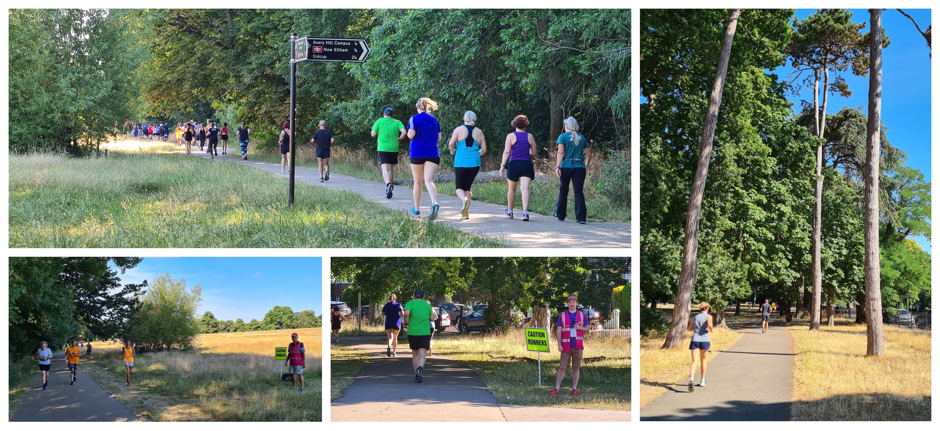
Once in the park, the point to head for is the main central hub which contains the visitor centre and cafe at the southern tip of the second largest of the lakes, Overton Lake. The toilets can be found adjacent to the cafe and car park and were already open when we arrived at 8.20am. As the clock reaches 9am there's a first-timer briefing opposite the cafe followed by the main briefing at the start line which is just a bit further along the path. The course is best described as a single lap consisting of two different out-and-back sections and it is flat. Participants are asked to keep to the left at all times. The surface underfoot is 100% tarmac so road shoes are the shoe of choice here all year around. Buggy runners will be just fine on this course, but it is a very well attended event so watch out for congestion during the first kilometre or so.


The course first heads out to the north for a small anti-clockwise loop around Lynch Lake, which is the smallest of the park's lakes. This one is mostly used for children's activities such as pond dipping. The sheer number of people here will inevitably result in people spreading out onto the adjacent grass, which we were told during the briefing is fine. Once the loop is complete the route heads back past the start line and the course continues on its longer out-and-back in the opposite direction.

Following the lakeside path along the edge of the Overton Lake the course passes the human sundial, the Badger Play playground and shortly after, a tree which features a carving of an owl. This section of course has quite a natural feel with woodland on either side. There's then a crossing of part the River Nene via Ham Bridge which leads into the North-eastern part of the park.


This part of the park feels more like being in the countryside. The areas to the right are meadows which were restored between 2017 and 2019 to wetland areas. They feature a network of cross ditches which help regulate the amount of water that is held throughout the year and this in turn provides a great habitat for various wetland birds. There are also cattle grazing in these fields, so if you keep an eye out you may spot the resident cows. Once past a small junction the course continues, but the lake to the left hand side is now Gunwade Lake.

Another loop exists at this end of the course, and this one is negotiated in a clockwise direction. During the loop the course passes the historic Milton Ferry Bridge which dates from 1716, so is just over 300 years old. It was built by the former owners of the land to replace the ferry service across the River Nene. The route the parkrun uses means that in order to get the best view of the bridge, participants would need to look backwards, so the majority may miss it. (It's worth wandering back over to check it out post-parkrun where you'll also find very scenic view from the bridge looking down the river).


With the loop complete, the course works its way back along the already trodden paths, back over the bridge and alongside the lake towards the original start point. The very last section of the course branches off to the right were the finish line is found. The finish also happens to be right next to the remains of the Roman Barn, so it's worth taking a quick peek before moving on. The barcode scanners can be found just after the finish line and once that is taken care of, the post-event refreshments venue is the Ferry Meadows Cafe where you can get a 10% discount by showing your parkrun barcode.

I recorded the parkrun course with my Garmin and the GPS data can be viewed on my Strava account. That data was also converted into a Relive course fly-by video and you can watch that on via my YouTube account. The results for event 420 were online a short while after and 427 people took part. The current attendance figures seem to be fairly consistent between the mid to high 400's, the slightly lower turnout when we visited was most likely due to it being the start of the summer holidays. The team here clearly have the whole thing down to a tee, and the event seemed to run like clockwork. The first-timers briefing was particularly good with all areas thoroughly covered along with a decent sprinkling of humour.


We had spent the previous afternoon in the park so had already explored it quite extensively, including all three playgrounds and the human sundial. We also had a ride on the miniature railway. So our parkrunday continued away from the park where we visited Flag Fen Archaeology Park, the Railworld Wildlife Haven and had a look around the centre of Peterborough. We went into the cathedral and we were able to see the burial spot of Katherine of Aragon, Henry VIII's first wife and Queen of England between 1509 and 1533 plus the original burial spot of Mary, Queen of Scots (her body was later moved to Westminster Abbey). It was quite a full-on and exhausting 24 hours in Peterborough, but very, very enjoyable!


Related links:


Sunday, 17 July 2022

Avery Hill parkrun (formerly Greenwich parkrun)

In South East London's Royal Borough of Greenwich you will find the district of Eltham which is home to around 88,000 people. It was apparently called Eald-Ham in Anglo-Saxon times when it was just a village. It's positioning on a high plateau meant that it was strategically significant and this lead to Eltham's most famous feature being built. This is a large country house called Eltham Palace. Between c.1305 and c.1630 it became a home of the monarchs and Henry VIII is known to have spent part of his childhood here. The current building dates from the 1930s but crucially the medieval Great Hall built in the 1470s was central to the design, and has been preserved. It boasts the third largest hammerbeam roof in England.

Nearby is another former significant residence, Avery Hill Mansion, which would have been the centrepiece of the Avery Hill Estate. There has been a mansion in some shape or form on this site for over two hundred years, but the current building was constructed in 1890. It was built and owned by an obscenely wealthy man called John North. Much of his wealth came from the Chilean nitrate industry of which he held a significant share. He was a prominent public figure in his day and became known as 'The Nitrate King'. The building has apparently been described by Historic England as an example of 'late Victorian vulgarity' due to it extravagance and quality of materials.


A notable part of the building is the Winter Garden. This is the second largest Victorian glasshouse in the UK. Only the Temperate House at Kew Gardens is larger. The former mansion has had several educational uses since it ceased being a residence. A teaching college was here for many years until it closed in the mid-1980s. The most-recent use had been as one of Greenwich University's campus's but this ended in 2020. The former mansion and extended area is currently being redeveloped into a brand new Harris Academy school for boys and is scheduled to open in 2023. The development also includes the refurbishment of the Winter Garden. Under normal circumstances this would be open to the public, however at time of writing (July 2022) it is closed. If you peep through the eastern conservatory window you should be able to see the 1882 marble statue 'Galatea reclining on a dolphin'. Update March 2024: the Winter Garden is now open to the public.

The grounds were purchased by the London County Council in 1902 and opened as a public park called Avery Hill Park. Its ownership/maintenance passed to the Greater London Council in 1965 and then to The London Borough of Greenwich (now the Royal Borough of Greenwich) in the mid-1980s. Avery Hill Park is set in 90 hectares of parkland which is laid out in much the same fashion as it would have been in the past. It is largely comprised of open grass fields and meadows. It is thought that many of the field boundaries date back over 400 years, with some even older than that. Many of the trees here would have been planted by the estate's various owners for landscaping purposes and are well over 100 years old (some have even passed their 200th birthdays). There are tree preservation orders in place in some of the most significant examples.


The modern-day park also features a café, playground, and an enclosed tarmac five-a-side football pitch and basket court. Until recently there was also a BMX facility called Avery Hill Trails which were the longest standing BMX trails in inner London. Sadly the development of the Harris Academy has lead to this being closed down. Since March 2010 the park has been home to a free, weekly, timed 5km event which for its first 15 years was called Greenwich parkrun. I had previously noted that this location is not what most people would class as 'Greenwich' (The Cutty Sark is 5 miles away), and I'm guessing this detail has lead to some confusion for visitors over the years. Back in 2010 the parkrun naming convention wasn't quite as refined as it is now.

On 26 February 2025 it was announced that from 8 March 2025, the event would become Avery Hill parkrun.

We first visited this venue in May 2013 where I participated with my daughter in the running buggy and then again on Christmas Day in 2016 (without the buggy). So this visit marked my third time taking part here, but it was the first time for the rest of the family. We have been back twice since this write-up was initially posted, bring my total number of visits to five.


Car parking details on a variety of websites seem to be purposefully vague for this park. However there are a couple of parking options - firstly there is an on-site car park which I believe is free-of-charge at weekends and has space for 40 vehicles (things are currently a bit strange as the main larger section is closed due to the building works). The car park is accessed from Bexley Road via the red-bricked Gatehouse. The second parking option is to use the parking bays on Avery Hill Road which runs along the park's eastern border, these spaces are free-of-charge at all times. The nearby residential streets to the east also seem to be free of restrictions but it would make sense to avoid using these if at all possible.

If travelling by train there are two lines which run close-by. The first option is Eltham Station, which is just to the north-west of the park and is a short walk away (1.4 miles) along the High Street - this is on the line that runs between London and Dartford via Bexleyheath. Alternatively, if you happen to be using the London to Dartford via Sidcup line, you can alight at New Eltham. Station This is to the south of the park and if you take the shortest route is only 1.2 miles away. I use these two lines to travel to and from work, so know them pretty well. There are many bus services that stop outside the park on Bexley Road. If cycling there are bicycle racks right outside the café in the centre of the park. The toilets can be found in the café building, but please note that there is only one shared regular toilet plus one accessible toilet, so it's likely that a queue may form.


Should an overnight stay be required, there is a cheap and cheerful hotel quite close to the park called The Eltham Hotel. It is very basic, but is well positioned for the event and seems to get good reviews. There are two Premier Inns fairly close by. The closest is the Eltham branch which is on the A20, and the second is just down the road, in Sidcup. There's also a Travelodge in Sidcup.

Once in the park the meeting point for the parkrun is adjacent to the central hub which contains the cafe (with toilet) and playground. The course consists of three anti-clockwise laps with the surface underfoot being an almost even split of tarmac and grass. Road shoes are fine in summer, but you may find trail shoes work a bit better during the winter or very wet conditions. The profile can be described as gently undulating and what you'll generally find is that when you are moving away from the mansion you'll be heading downhill and the uphill sections are the bits that head back towards the mansion. As I mentioned earlier I have used the running buggy on this course and it was absolutely fine (in fact it is better now because the lower section of the course used to be grass with tree roots, but that section now features a tarmac path).


The start line is on the grass next to the enclosed five-a-side football pitch and after the briefing the participants are sent off on their 5km run, jog or walk around the park. The first section of the lap is on grass and this goes alongside the park's marked football fields. At the point where the course takes its first left turn a quick glance to the right will reveal Henley's Meadow (or Henley's Field), this is the park's wildflower meadow and is named after John De Henley, owner of the fields during the 13th century. In fact there are records that show King Edward II bought hay from De Henley to feed to the deer at Eltham Palace. The Green Chain walking route passes through this end of the park.

At this point on the course there's a short, sharp drop followed by an ongoing, very slight downhill (which feels flat) as the route heads down towards the lower section of the park. Here the course joins the tarmac path and this meanders nicely until it bears around and follows the border with Avery Hill Road up to the top of the park until reaching the Winter Garden glasshouse which is a great sight at the top of the park. The route now rejoins the grass and heads back towards the start area where the loop repeats a second and third time. At the end of the third lap the finish line can be found on the grass inbetween the mansion and the cafe. With the morning's excercise complete, it's a simple case of presenting your barcode and finishing token to one of the barcode scanners who will be positioned nearby. Also keep your eye out for the incredible token sorting board!


The on-site Avery Hill Park Cafe provides the setting for the post-event refreshments. They serve all the usual things you'd expect from a park cafe, so it is the perfect spot to have a chilled-out natter and refreshments with your fellow parkrunners. If you really felt like it you could bring along some chess pieces and have a post-parkrun game of chess on the permanent chess table and chairs set. On this occasion we had to be elsewhere so headed straight off home where I uploaded the day's GPS data to Strava and created a Relive course fly-by video, so please take a look at those if you would like to see visual representations of the course.

The official results for event 589 were processed and published shortly after and 140 people had taken part, which is pretty much spot-on for the current expected turnout. Interestingly, before the great lockdown there were in excess of 300 people attending every week (sometimes even over 400). When parkrun returned the numbers were generally in the 200s, but this then suddenly dropped to the mid-100s. The biggest factor in the current attendance figures seems to be the nearby Sutcliffe parkrun which started in September 2021 and appears to have taken a bit of pressure off this lovely South East London park.


Avery Hill parkrun has a very well established team whose volunteers run a slick operation alongside an amazing extended local community. The volunteers on-the-day were all wonderful and I witnessed so much joy and kindness during the event. I do feel that I should give a special mention, and thanks, to the tail walker, Kit, who accompanied my wife and kids throughout the event and somehow encouraged my son to a new 5k PB by almost four-and-a-half minutes! So, if you haven't visited this venue then you really should swing by and check it out!


Related links:


Sunday, 10 July 2022

Littlehampton Prom parkrun

Littlehampton is a seaside town located on the south coast in West Sussex. It was recorded in the Domesday Book as the hamlet of Hantone, but had also been recorded elsewhere as Hanton. The town developed initially as a fishing community and then as a port. The ownership of the area has largely sat with the Duke of Norfolk, who also holds the title of Earl of Arundel. This is one of England's oldest surviving Earldoms having been created in c.1138 and the Duke of Norfolk is the most senior Peer in the Peerage of England. A tradition which was written into law in 1627 is that the holder of Arundel Castle is automatically the Earl of Arundel. In fact the port at Littlehampton was known as Arundel Port around the 18th century. It's name eventually became Littlehampton and it is thought that this was to distinguish it from the larger Southampton which is just to the west.


The town is located on the mouth of the River Arun which flows through the town. The area was susceptible to attack by the French, and in 1760 a battery was erected on the river's east bank to add some protection. In 1854, to protect against a new threat from the French, the more substantial 'Littlehampton Redoubt' (commonly known as Littlehampton Fort) was built on the river's west bank. The fort is still standing but is now best described as an overgrown ruin. The east bank was also home to Arun Mill, which was one of the largest windmills ever built in Sussex.

The 18th and 19th centuries saw Littlehampton also start to develop as a holiday resort and in 1863 the railway came to town when Littlehampton Station was opened. By the 1920's the holiday resort had become known as The Children's Paradise. In 1932 Arun Mill (windmill) was demolished to make way for an amusement park owned and run by Billy Butlin. This was subsequently bought by the a family called the Smart's in 1977 and the name changed to Smart's Amusement Park. It is now called Harbour Park, however I gather that you may still hear some locals referring to it as Smart's. The amusement park is situated right next to the mouth of the River Arun and part of it sits on the rampart of the 1760 battery. The reference to the Windmill still lives on in the name of the cinema (formerly a shelter hall and a theatre) and a pub, both next to the amusement park.


The East Bank is now the location of the town's free, weekly, timed, 5k event, Littlehampton Prom parkrun. We visited on a gloriously sunny day in July 2022 and parked in West Green Car Park (which is on the East Bank). The car park fees can vary depending on the time of year, however if you are visiting for the parkrun and then leaving straight away the charge can be reasonably cheap (see the Arun Council website for info). We had decided to turn our parkrun visit into a day out so we had to pay the full day's fee which was £11, which to me seemed eye wateringly expensive. The full day rate is considerably cheaper during the winter. If you are a little more organised and don't mind a longer walk you may be able to find some free parking further inland on the residential streets in the town.

Travel is of course possible by train to Littlehampton Station which is the terminus on the main line running from London Victoria via East Croydon, Hove and Worthing. The onward walk to the parkrun meeting point is approximately 0.8 miles (1.3km). There is also a Stagecoach bus, number 700, which stops near the train station, so the walk will be about the same. For cyclists I saw some bicycle racks over near the car park. There are toilets and these are located in the area in between the car park and the seafront. I understand these toilets open at 8am all year round.


The parkrun meeting point is on the seafront right in the corner next to the river mouth and amusement park, One of the best visual guides is to look out for is the white tower, which I understand contained (or maybe still contains) a light (it's a lighthouse) to mark the entrance to the River Arun / Littlehampton Harbour. It may be known as Littlehampton East Pier Lighthouse or Littlehampton East Pier Range and from what I can see it dates from 1948. Also look out for the former coastguard station with a tower that apparently had a gun mounted during the Second World War. It is located right at the start/finish line and is now apparently a unique holiday rental home called The Little Lookout (imagine waking up here and going to parkrun).

As you may have guessed by the name, the parkrun takes place on the prom. This is a double out-and-back course along the seafront. It is completely flat and underfoot is 100% tarmac, so road shoes are the ones to go for all year round. Buggy runners and wheelchair users would be absolutely fine on this course. As is common for seafront venues, it can suffer from harsh weather conditions at times. On the day we took part there was a headwind on the 'out' leg. Fortunately that meant that the 'back' leg had a tailwind. However it was so hot that the breeze was quite a welcome addition.


Heading out from the start, the course immediately passes the former coastguard station followed by the bank of shops which sell fish and chips, ice cream, donuts and all sorts of beach-themed items to the hoards of people that gather here in good weather. Glancing to the right you may be able to see the Rampion Offshore Wind Farm. This consists of 116 wind turbine generators which generate 1,400GQh and is enough to provide power to 350,000 homes. The wind farm and associated infrastructure was constructed between 2015 and 2017. It first started generating power to the national grid in November 2017 and by April 2018 was fully operational with all 116 turbines running.

While heading along the prom the parkrunners keep to their left, this ensures that everyone can pass safely as outgoing and returning parkrunners start to interact. Look out for The Long Bench. This bench is 324 metres long and is made from stainless steel and 9,000 wooden slats. It weaves its way along the prom, sometimes twisted and looped within the shelters that form the two ends of the bench. It is the longest bench in the UK and it can theoretically seat around 300 people at any one time.


Towards the eastern end of the course there are brightly coloured beach huts nestled in small batches on the beach. Watch out along here as there are benches which protrude onto the path. On the opposite side of the road you will find Littlehampton Miniature Railway, which dates from 1948 and runs on a 12 1/4 inch gauge line. This gauge is apparently extremely rare and there are only six in existence with Littlehampton being the oldest. The line is 800 yards long and has two stations Norfolk Road and Mewsbrook Park.

Before long the turnaround point is reached - it is marked with a cone and a marshal. The return leg takes you back along the same path, again keeping the left. On the return leg you may encounter stones on the path as these can spill over from the adjacent beach. Look out for the Littlehampton Beacon which is on the beach, it was lit as part of the Queen's Jubilee (2012) and Platinum (2022) celebrations beacon lighting events. The Littlehampton Urban District Council coat of arms hangs alongside the beacon. It features a Martlet (a mythical bird without feet that never roosts) in between the cross-crosslets from the Howard family arms (Edward Fitzalan-Howard is the current Duke of Norfolk). The ship represents the fact the the town is a port (see photo). At the bottom is the town's motto 'Progress'.


The halfway point is reached just in front of the shops mentioned earlier where there is now a turnaround point marked by a marshal and cone. The out-and-back is negotiated a second time and the finish is found back at the original start line. The open area here is nice and spacious with plenty of room for some post-event recovery before being scanned by one of the barcode scanners. I recorded the route using my Garmin and you can find the GPS data online on Strava. That data was also used to create a Relive course fly-by video and that can be viewed on YouTube. The results for event 97 were processed and online shortly after the last participants had finished. Many thanks to all the volunteers.

The official course page says that the team grab refreshments at a local cafe, but it doesn't say which one. We decided to go into the adjacent The Windmill pub, which is run by Harvester, for breakfast. They had a good selection of offerings for all diets including vegetarian and vegan, and it was very tasty. Sadly the pub suffered a major fire in August 2023, and is not currently open.


We continued our day with another walk along the prom, stopped at a playground we had spotted during the parkrun, had a ride on the miniature railway and hung out in the beautiful Mewsbrook Park with its boating lake and art-deco features. The weather was perfect for a seaside day out and we finished our day hanging out on the beach and splashing in the sea.


Related Links:


Tuesday, 5 July 2022

Riddlesdown parkrun

Riddlesdown is an area located in the London Borough of Croydon. The 'Riddle' part of the name is thought to be linked to the Middle English phrase 'Riddle Leah' or 'Riddeleah' which means 'cleared woodland' or possibly 'cleared woodland on a hill'. Over the years the area has used various versions of the name. The first recorded example is Ridelesdoune from 1331. It has subsequently been known as Redele, North Ridle, Riddleys, North Riddeley and by 1765 was known as Riddles Down.

Riddlesdown / Chalk cliff


Adjacent to the residential settlement is Riddlesdown Common. This is a 43 hectare area of open natural space located on the North Downs and is comprised of chalk grassland and ancient woodland. It also forms part of the larger 'Sanderstead to Whyteleafe Countryside Area'. Riddlesdown Common itself is managed by the City of London Corporation and was given National Nature Reserve (NNR) status in 2019. The common also features a section which has been designated as a Site of Special Scientific Interest (SSSI). Historically the area has been used as a grazing area for livestock and the old Roman road from London to Brighton passed across the area, most likely to avoid to valley beneath which was prone to flooding.

From the late 1700s until 1967 there was a chalk quarry on Riddlesdown's western face which also included a narrow gauge railway to move the materials around. You can see the chalk cliff face from the nearby A22 road, or for a better view, head to the top of New Barn Lane, Kenley. There is apparently a network of tunnels (secret passages?) underneath the downs and these were used during the Second World War as bomb shelters. There were enough beds for 1500 people to sleep inside while seeking protection from air raids. There was apparently running water, electricity a canteen and toilets contained within. On the subject of tunnels, the train line south of Riddlesdown station travels underneath the common.

with our longest-known and favourite parkrun person, Nicki (she gets a full photo rather than a collage)


The City of London Corporation bought Riddlesdown Common in 1883 to protect it from enclosure and to safeguard the grazing rights for the local people. Following this, in 1892, a man called William Gardner opened a tea garden on the lower slopes. It was called Gardner's Pleasure Resort (and possibly also Riddlesdown Tea Gardens) and apparently attracted many visitors from the centre of London. There was a monkey house, aviary, donkey rides and various fairground-style attractions such as coconut shy and hoop-la. By 1906 it could seat 500 people and also contained further entertainment facilities such as a stage and outer pavilion which could hold hold up to 2000 people. The attraction was closed down and sold for housing shortly after William Gardner died in 1930. Records show there may have also been a rifle range in the early 20th century.

In 1996 The City of London Corporation purchased the former chalk quarry and it now forms part of the SSSI. However due to safety concerns it is not generally open to the public. The modern day area is a long strip of countryside nestled within the adjacent residential areas, and there are no real facilities to speak of. On 2 July 2011 the area became home to its very own free, weekly, timed 5km event called Riddlesdown parkrun, and this is a special venue for me as it was my very first proper parkrun home. I took part in every event for the entire first year and we really became part of that early Riddlesdown parkrun community lead by the event director, parkrun's most prolific volunteer, Nicki Clark. It was also my first ever attempt at a venue description blog.


Start area


The parkrun has very close links with the adjacent Warlingham School, and it is the school that kindly lends its car park and toilet facilities to the event every Saturday morning. Access to the car park and toilets is from Tithe Pit Shaw Lane. Please note that the event also sometimes uses the Tandridge Learning Trust car park, which is further along the same road - if in doubt, look out for the car park marshals who will give advice on the day. It is then just a few minutes walk across the road and onto the downs with the initial assembly point (and pre-event natter) being right next to the entrance. Travel by public transport is possible by train - Riddlesdown, Kenley, Whyteleafe and Upper Warlingham stations are all nearby. I've never taken the train to Riddlesdown, but I would say the latter two would probably be the best options, just be prepared for the uphill walk to the downs. Local buses that pass nearby are the 403 and 407.

Despite the fairly high elevation of the downs (525ft / 160m above sea level), the course itself is relatively flat. The terrain is of the off-road nature, so you'll find grass, dirt, mud, tree roots and stones all feature as part of the route. With this in mind I would say trail shoes are the obvious choice for a visit at any time of year, but bear in mind that in the winter they are essential as Riddlesdown parkrun is infamous for being a mud bath! Participants with buggies are of course welcome, but please note the previous point about the mud! I've used the running buggy here on multiple occasions and cleaning it afterwards was not fun on after those muddy events.

Around the fields


The original course was in use from the very first event in 2011 through until the Covid lockdown. However when Riddlesdown parkrun returned in 2021, it did so with a brand new course (exciting!). The start of the parkrun is actually on one of the adjacent fields, so make sure you arrive with enough time to walk across. Bear in mind that you have to follow the marked paths at all times as the central areas are essentially fields containing long grasses which are cut to make hay every so often. The fields are also home to nesting Skylarks and the fields are protected zones.

The new course consists of two laps followed by a tail that leads towards the finish. The start is located on a corner and is extremely narrow, so you'll need to take care to seed yourself sensibly. An interesting fact is that the new course takes place entirely within the Sanderstead to Whyteleafe Countryside Area and no longer passes through the City of London owned Riddlesdown Common. Each of the fields are named and the start area is located within 'Ibetts Piece', which is on land managed by Croydon Council. The course winds its way along the outer edge of Ibetts Piece before passing through the tree line and into the next field 'Long Acres' and shortly after that into the third field '20 Acres'.

The fields


The next part of the course will be familiar to anyone who has visited Riddlesdown parkrun in the past. Upon leaving 20 Acres, the route reaches Barrie's Bend (formerly Condon Corner) (but from a different approaching path), and this marks the beginning of the trail section that runs through the trees. The first part of this is characterised by its uneven stony surface where extreme care is required to avoid tripping. Thankfully the path smooths out as it progresses.

Keep an eye out for the Trig Point about half-way along - this marks the highest point of the downs. This section also forms part of The London Loop walking route. At the end of the path the course enters the fourth field which I understand is called Dipsley Field and after a couple of hundred meters the course turns left back into Ibetts Piece and the first lap (2.15km) is complete.

The path through the trees / London Loop


The second lap is identical to the first but instead of turning into Ibetts Piece the course continues straight on. The remaining 700 metres are covered on a long tail which leads all the way to the end of the field and then along the eastern border and into the finish funnel. The finish is right next to the original assembly point near the Tithe Pit Shaw Lane entrance and barcode scanning takes place at the table under the tree. It's also worth noting that the last section of the course and the finish are within Surrey (although I understand the land is managed by Croydon Council), so this makes Riddlesdown parkrun unique in the fact that it starts inside London and finishes outside. 

I had recorded the course using my Garmin so please feel free to take a look at the data on Strava for a more detailed visual of the course. I also made a Relive course fly-by video with the data, so again that may help with visualising the course. I'd note that the course remains narrow most of the way around, so if you start out of position it may take a kilometre or so to filter into your natural place in the field.

Heading towards the finish


The results for event 524 were processed shortly afterwards and 143 people completed the 5k course, this is not far off the overall average which as of 2 July 2022 stands at 127.1. On a beautiful sunny morning in July the course is such a pleasure to run, but be aware that if visiting in the winter it is a very different beast and a change of socks and shoes (at least) is very likely to be required (I'm speaking from experience - this was my 75th official finish here). Riddlesdown parkrun is still also my most-volunteered at event and accounts for over half of my V250 club membership. Usually as report writer, photographer and half-way timer, but mostly as the communications person (I was once dubbed the invisible volunteer!). I do very much miss compiling the event quick stats every Saturday afternoon!

When the weather turns it is not unusual for the attendees to drop down into double figures which is understandable as many people may prefer to avoid the mud bath. The venue has been the location of some of my most memorable parkruns. Notably the first time I saw it covered in a snow (click to see some stunning photos) and another time when the entire downs was covered in fog. Both were incredible!

The finish


The post-parkrun refreshments venue has changed a few times over the years, but the current place to go is the Whyteleafe Park Pavilion in the adjacent Whyteleafe Park which is also part of the Sanderstead to Whyteleafe Countryside Area (it's near Whyteleafe and Upper Warlingham train stations). If you arrived by vehicle you'd need to move it down to the cafe to avoid being locked in the school. The cafe car park is small, but free-of-charge (if you visit Monday-Friday you will need to obtain a free ticket from the machine, but this is not required on Saturdays). On this visit we didn't make it to the cafe as the 11 year anniversary celebrations took place over in the school grounds.

However a few weeks later we did get to sample the new post-event facilities when we popped back over to help Nicki celebrate her 50th parkrun. It's a great little spot, especially in the summer, with the cafe overlooking the sweeping landscape that is the park, and in the far distance you can see the steep footpaths that climb up onto the higher plateau of Riddlesdown. There's also a playground for the kids. The menu at the cafe is reasonably priced but quite limited.

Whyteleafe Park and cafe


Much like the original, the updated parkrun course is a joy to run/walk. If you visit regularly you'll get to experience the changing seasons and underfoot course conditions. It's such a nice, peaceful place to spend an hour or so on a Saturday morning.


V1000

Another interesting fact concerning Riddlesdown parkrun is that on 23 March 2024 the Event Director, Nicki, became the first person in the world to reach the 1000 milestone for volunteering and the new V1000 t-shirt was revealed. We were of course there to help her celebrate the occasion! It was a fantastic morning of celebration which has to go down as one of my most memorable parkrundays.

V1000


As always, a huge thanks goes to the wonderful team of volunteers that take the time and effort to put the event on every week.


Related links:


Related Posts Plugin for WordPress, Blogger...